National Register of Historic Places listings in Stutsman County, North Dakota

This is a list of the National Register of Historic Places listings in Stutsman County, North Dakota.
This is intended to be a complete list of the properties and districts on the National Register of Historic Places in Stutsman County, North Dakota, United States. The locations of National Register properties and districts for which the latitude and longitude coordinates are included below, may be seen in a map.[1]
There are 10 properties and districts listed on the National Register in the county. Another two properties were once listed but have been removed.
Map all coordinates using OpenStreetMap
Download coordinates as:
- KML
- GPX (all coordinates)
- GPX (primary coordinates)
- GPX (secondary coordinates)
| Adams | Barnes | Benson | Billings | Bottineau | Bowman | Burke | Burleigh | Cass | Cavalier | Dickey | Divide | Dunn | Eddy | Emmons | Foster | Golden Valley | Grand Forks | Grant | Griggs | Hettinger | Kidder | LaMoure | Logan | McHenry | McIntosh | McKenzie | McLean | Mercer | Morton | Mountrail | Nelson | Oliver | Pembina | Pierce | Ramsey | Ransom | Renville | Richland | Rolette | Sargent | Sheridan | Sioux | Slope | Stark | Steele | Stutsman | Towner | Traill | Walsh | Ward | Wells | Williams |
This National Park Service list is complete through NPS recent listings posted September 5, 2024.[2]
Current listings
| [3] | Name on the Register | Image | Date listed[4] | Location | City or town | Description |
|---|---|---|---|---|---|---|
| 1 | Stephen William Brown Stone House | 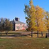 | February 4, 2004 (#03001545) | 4829 75 R Ave., SE 46°42′58″N 98°52′57″W / 46.716111°N 98.8825°W / 46.716111; -98.8825 (Stephen William Brown Stone House) | Montpelier | |
| 2 | Alfred E. Dickey Free Library | 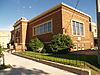 | July 3, 1980 (#80004545) | 105 3rd St., SE. 46°54′24″N 98°42′28″W / 46.906667°N 98.707778°W / 46.906667; -98.707778 (Alfred E. Dickey Free Library) | Jamestown | |
| 3 | Elizabeth Apartments |  | April 21, 1986 (#86000871) | 402 2nd Ave. NW. 46°54′43″N 98°42′35″W / 46.911843°N 98.709707°W / 46.911843; -98.709707 (Elizabeth Apartments) | Jamestown | |
| 4 | Franklin School |  | May 9, 2002 (#02000474) | 308 2nd St. SW. 46°54′28″N 98°42′42″W / 46.907778°N 98.711667°W / 46.907778; -98.711667 (Franklin School) | Jamestown | |
| 5 | Grace Episcopal Church |  | December 3, 1992 (#92001606) | Northwestern corner of the junction of 2nd Ave. NE. and 4th St. NE. 46°54′41″N 98°42′23″W / 46.911389°N 98.706389°W / 46.911389; -98.706389 (Grace Episcopal Church) | Jamestown | |
| 6 | Jamestown Historic District | Upload image | September 8, 1989 (#88000987) | Roughly bounded by 1st St., 4th Ave., SE., 5th St., and 2nd Ave. 46°54′20″N 98°42′23″W / 46.905556°N 98.706389°W / 46.905556; -98.706389 (Jamestown Historic District) | Jamestown | |
| 7 | Seiler Building |  | January 16, 1986 (#86000080) | 110 1st St., E. 46°54′30″N 98°42′25″W / 46.908333°N 98.706944°W / 46.908333; -98.706944 (Seiler Building) | Jamestown | |
| 8 | St. James Catholic Church | 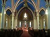 | October 22, 1982 (#82001346) | 622 1st Ave., S. 46°54′10″N 98°42′32″W / 46.902805°N 98.708869°W / 46.902805; -98.708869 (St. James Catholic Church) | Jamestown | |
| 9 | Stutsman County Courthouse and Sheriff's Residence/Jail | 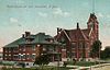 | September 8, 1976 (#76001356) | 504 3rd Ave., SE. 46°54′13″N 98°42′20″W / 46.903611°N 98.705556°W / 46.903611; -98.705556 (Stutsman County Courthouse and Sheriff's Residence/Jail) | Jamestown | |
| 10 | Voorhees Chapel |  | July 22, 1977 (#77001030) | Jamestown College campus 46°54′52″N 98°41′57″W / 46.914444°N 98.699167°W / 46.914444; -98.699167 (Voorhees Chapel) | Jamestown |
Former listing
| [3] | Name on the Register | Image | Date listed | Date removed | Location | City or town | Description |
|---|---|---|---|---|---|---|---|
| 1 | Cecil Baker Round Barn | Upload image | August 21, 1986 (#86002759) | March 28, 2011 | ND 38 47°15′13″N 98°52′47″W / 47.2536°N 98.8797°W / 47.2536; -98.8797 (Cecil Baker Round Barn) | Kensal | Demolished 2010 [5] |
| 2 | Midland Continental Overpass | Upload image | February 27, 1997 (#97000194) | July 18, 2024 | Over an abandoned railroad grade, former U.S. Route 10, approximately 7 miles east of Jamestown 46°56′09″N 98°32′55″W / 46.935833°N 98.548611°W / 46.935833; -98.548611 (Midland Continental Overpass) | Jamestown | Replaced in 2005 |
See also
Wikimedia Commons has media related to National Register of Historic Places in Stutsman County, North Dakota.
- List of National Historic Landmarks in North Dakota
- National Register of Historic Places listings in North Dakota
References
- ^ The latitude and longitude information provided in this table was derived originally from the National Register Information System, which has been found to be fairly accurate for about 99% of listings. Some locations in this table may have been corrected to current GPS standards.
- ^ National Park Service, United States Department of the Interior, "National Register of Historic Places: Weekly List Actions", retrieved September 5, 2024.
- ^ a b Numbers represent an alphabetical ordering by significant words. Various colorings, defined here, differentiate National Historic Landmarks and historic districts from other NRHP buildings, structures, sites or objects.
- ^ The eight-digit number below each date is the number assigned to each location in the National Register Information System database, which can be viewed by clicking the number.
- ^ State Historical Society of North Dakota
- v
- t
- e
- Jamestown Historic District

- Stephen William Brown Stone House
- Alfred E. Dickey Free Library
- Elizabeth Apartments
- Franklin School
- Grace Episcopal Church
- Midland Continental Overpass
- Seiler Building
- St. James Catholic Church
- Stutsman County Courthouse and Sheriff's Residence/Jail
- Voorhees Chapel
See also: National Register of Historic Places listings in Stutsman County, North Dakota and List of National Historic Landmarks in North Dakota
| ||
|---|---|---|
| Topics |  | |
| Lists by county |
| |
| Other lists | ||
| ||


Municipalities and communities of Stutsman County, North Dakota, United States | ||
|---|---|---|
County seat: Jamestown | ||
| Cities |  | |
| Townships |
| |
| Unorganized territories |
| |
| CDPs | ||
| Other communities | ||
| ||


