National Register of Historic Places listings in West Feliciana Parish, Louisiana

This is a list of the National Register of Historic Places listings in West Feliciana Parish, Louisiana.
This is intended to be a complete list of the properties and districts on the National Register of Historic Places in West Feliciana Parish, Louisiana, United States. The locations of National Register properties and districts for which the latitude and longitude coordinates are included below, may be seen in a map.[1]
There are 32 properties and districts listed on the National Register in the parish, including 1 National Historic Landmark.
This National Park Service list is complete through NPS recent listings posted August 23, 2024.[2]
Map all coordinates using OpenStreetMap
Download coordinates as:
- KML
- GPX (all coordinates)
- GPX (primary coordinates)
- GPX (secondary coordinates)
Current listings
| [3] | Name on the Register[4] | Image | Date listed[5] | Location | City or town | Description |
|---|---|---|---|---|---|---|
| 1 | 3 V Tourist Court |  | January 21, 1993 (#92001832) | 111 E. Commerce St. 30°46′44″N 91°22′32″W / 30.778889°N 91.375556°W / 30.778889; -91.375556 (3 V Tourist Court) | St. Francisville | |
| 2 | Afton Villa Gardens |  | February 24, 1983 (#83000554) | North of St. Francisville on U.S. Route 61 30°51′06″N 91°23′17″W / 30.851667°N 91.388056°W / 30.851667; -91.388056 (Afton Villa Gardens) | St. Francisville | |
| 3 | Bloodhound Site | Upload image | May 2, 1983 (#83000555) | Address Restricted | Angola | An archaeological site once occupied by the Tunica tribe. |
| 4 | Butler-Greenwood Plantation |  | April 17, 1979 (#79001103) | North of St. Francisville on U.S. Route 61 30°49′11″N 91°23′23″W / 30.819722°N 91.389722°W / 30.819722; -91.389722 (Butler-Greenwood Plantation) | St. Francisville | |
| 5 | Catalpa | Upload image | July 12, 1984 (#84001367) | U.S. Route 61 30°51′04″N 91°22′33″W / 30.851111°N 91.375833°W / 30.851111; -91.375833 (Catalpa) | St. Francisville | |
| 6 | Como Plantation | Upload image | October 10, 2017 (#100001714) | 5000 Como Rd. 30°54′23″N 91°31′18″W / 30.906279°N 91.521670°W / 30.906279; -91.521670 (Como Plantation) | Weyanoke | |
| 7 | Cottage Plantation | Upload image | March 17, 1975 (#75000857) | 6 miles north of St. Francisville on U.S. Route 61 30°51′11″N 91°21′37″W / 30.853056°N 91.360278°W / 30.853056; -91.360278 (Cottage Plantation) | St. Francisville | |
| 8 | John S. Dawson High School | Upload image | June 15, 2015 (#15000348) | 7565 Tunica Trace 30°50′36″N 91°24′06″W / 30.8432°N 91.4018°W / 30.8432; -91.4018 (John S. Dawson High School) | St. Francisville vicinity | |
| 9 | Grace Episcopal Church |  | March 28, 1979 (#79001102) | 510 Ferdinand St. 30°46′33″N 91°23′14″W / 30.775833°N 91.387222°W / 30.775833; -91.387222 (Grace Episcopal Church) | St. Francisville | |
| 10 | Hazelwood Plantation |  | July 31, 1978 (#78001438) | Southeast of Laurel Hill on Hazelwood Rd. 30°56′56″N 91°19′56″W / 30.948889°N 91.332222°W / 30.948889; -91.332222 (Hazelwood Plantation) | Laurel Hill | |
| 11 | Highland | Upload image | August 23, 1983 (#83000556) | Northwest of St. Francisville, off Highland Rd. 30°53′08″N 91°25′49″W / 30.885556°N 91.430278°W / 30.885556; -91.430278 (Highland) | St. Francisville | |
| 12 | Laurel Hill | Upload image | June 6, 1980 (#80001770) | Northeast of St. Francisville 30°57′41″N 91°19′33″W / 30.961389°N 91.325833°W / 30.961389; -91.325833 (Laurel Hill) | St. Francisville | |
| 13 | Live Oak |  | March 11, 1977 (#77000680) | 1.3 miles south of Weyanoke 30°56′00″N 91°27′17″W / 30.933333°N 91.454722°W / 30.933333; -91.454722 (Live Oak) | Weyanoke | |
| 14 | Myrtles Plantation |  | September 6, 1978 (#78001439) | U.S. Route 61 30°48′11″N 91°23′15″W / 30.803056°N 91.3875°W / 30.803056; -91.3875 (Myrtles Plantation) | St. Francisville | |
| 15 | Oak Grove Plantation Dependencies | Upload image | February 13, 1992 (#92000036) | U.S. Route 61, south of its junction with Louisiana Highway 421 30°52′34″N 91°21′58″W / 30.876111°N 91.366111°W / 30.876111; -91.366111 (Oak Grove Plantation Dependencies) | St. Francisville | |
| 16 | Oakley Plantation House | 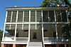 | January 25, 1973 (#73000878) | 4.5 miles east of St. Francisville at Audubon State Historic Site 30°47′48″N 91°18′26″W / 30.796667°N 91.307222°W / 30.796667; -91.307222 (Oakley Plantation House) | St. Francisville | John James Audubon worked here as Eliza Pirrie's art tutor, for four months in 1821. He painted 32 of his famous Birds of America during that time. Audubon's wife Lucy also taught at Oakley. |
| 17 | The Oaks | Upload image | August 20, 1979 (#79001101) | U.S. Route 61 30°48′34″N 91°23′12″W / 30.809444°N 91.386667°W / 30.809444; -91.386667 (The Oaks) | Hardwood | |
| 18 | Propinquity |  | March 26, 1973 (#73000879) | Royal and Johnson Sts. 30°46′27″N 91°23′11″W / 30.774167°N 91.386389°W / 30.774167; -91.386389 (Propinquity) | St. Francisville | |
| 19 | Red Hat Cell Block, Louisiana State Penitentiary |  | February 20, 2003 (#03000041) | Louisiana State Penitentiary 30°57′56″N 91°36′49″W / 30.965556°N 91.613611°W / 30.965556; -91.613611 (Red Hat Cell Block, Louisiana State Penitentiary) | Angola | |
| 20 | Rosale Plantation | Upload image | December 8, 1980 (#80001771) | North of St. Francisville off U.S. Route 61 30°51′52″N 91°21′36″W / 30.864444°N 91.36°W / 30.864444; -91.36 (Rosale Plantation) | St. Francisville | |
| 21 | Rosebank Plantation House | Upload image | April 13, 1973 (#73000880) | Southeast of Weyanoke off Louisiana Highway 66 30°55′27″N 91°26′33″W / 30.924167°N 91.4425°W / 30.924167; -91.4425 (Rosebank Plantation House) | Weyanoke | |
| 22 | Rosedown Plantation |  | August 7, 2001 (#01000765) | U.S. Route 61 and Louisiana Highway 10 30°47′58″N 91°22′23″W / 30.799444°N 91.373056°W / 30.799444; -91.373056 (Rosedown Plantation) | St. Francisville | |
| 23 | St. Francisville Historic District | Upload image | April 2, 1980 (#80001772) | Royal and Prosperity Sts.; also Ferdinand and Sewell Sts. 30°46′28″N 91°23′09″W / 30.774444°N 91.385833°W / 30.774444; -91.385833 (St. Francisville Historic District) | St. Francisville | Second set of addresses represents a boundary increase of October 1, 1982 |
| 24 | St. John's Episcopal Church |  | October 4, 1984 (#84000016) | Old Laurel Hill Rd. 30°57′24″N 91°20′29″W / 30.956667°N 91.341389°W / 30.956667; -91.341389 (St. John's Episcopal Church) | Laurel Hill | |
| 25 | St. Mary's Episcopal Church |  | September 29, 1980 (#80001774) | Northwest of Weyanoke on Louisiana Highway 66 30°57′56″N 91°28′11″W / 30.965556°N 91.469722°W / 30.965556; -91.469722 (St. Mary's Episcopal Church) | Weyanoke | |
| 26 | Solitude Plantation House | Upload image | January 27, 1983 (#83000558) | Northwest of St. Francisville on Tunica Rd. 30°49′17″N 91°25′26″W / 30.821389°N 91.423889°W / 30.821389; -91.423889 (Solitude Plantation House) | St. Francisville | |
| 27 | Star Hill Plantation Dependency | Upload image | July 24, 2003 (#03000680) | 5018 U.S. Route 61 30°45′56″N 91°19′00″W / 30.765556°N 91.316667°W / 30.765556; -91.316667 (Star Hill Plantation Dependency) | Star Hill | |
| 28 | Star Hill Post Office and Store | Upload image | February 4, 2000 (#00000038) | 4630 U.S. Route 61 30°45′43″N 91°18′24″W / 30.761944°N 91.306667°W / 30.761944; -91.306667 (Star Hill Post Office and Store) | St. Francisville | |
| 29 | Trudeau House | Upload image | July 28, 1995 (#95000919) | Junction of Louisiana Highway 66 and Old Tunica Rd. 30°56′06″N 91°32′15″W / 30.935°N 91.5375°W / 30.935; -91.5375 (Trudeau House) | Tunica | |
| 30 | Trudeau Landing | Upload image | June 17, 1977 (#77000679) | Address Restricted | Tunica | An archaeological site once occupied by the Tunica tribe. |
| 31 | Wakefield | Upload image | June 6, 1980 (#80001773) | U.S. Route 61 30°53′18″N 91°21′14″W / 30.888333°N 91.353889°W / 30.888333; -91.353889 (Wakefield) | Wakefield | |
| 32 | Weyanoke | Upload image | November 15, 1990 (#90001750) | Sligo Rd., 5 miles north of its junction with Louisiana Highway 66 30°56′14″N 91°25′03″W / 30.937222°N 91.4175°W / 30.937222; -91.4175 (Weyanoke) | Weyanoke |
See also
Wikimedia Commons has media related to National Register of Historic Places in West Feliciana Parish, Louisiana.
 National Register of Historic Places portal

- List of Louisiana state historic sites
- List of National Historic Landmarks in Louisiana
- National Register of Historic Places listings in East Feliciana Parish, Louisiana
External links
- West Feliciana Historical Society Museum
- West Feliciana Tourist Commission
References
- ^ The latitude and longitude information provided in this table was derived originally from the National Register Information System, which has been found to be fairly accurate for about 99% of listings. Some locations in this table may have been corrected to current GPS standards.
- ^ National Park Service, United States Department of the Interior, "National Register of Historic Places: Weekly List Actions", retrieved August 23, 2024.
- ^ Numbers represent an alphabetical ordering by significant words. Various colorings, defined here, differentiate National Historic Landmarks and historic districts from other NRHP buildings, structures, sites or objects.
- ^ "National Register Information System". National Register of Historic Places. National Park Service. March 13, 2009.
- ^ The eight-digit number below each date is the number assigned to each location in the National Register Information System database, which can be viewed by clicking the number.
- v
- t
- e
- List of U.S. National Historic Landmarks by state:
- Alabama
- Alaska
- Arizona
- Arkansas
- California
- Colorado
- Connecticut
- Delaware
- Florida
- Georgia
- Hawaii
- Idaho
- Illinois
- Indiana
- Iowa
- Kansas
- Kentucky
- Louisiana
- Maine
- Maryland
- Massachusetts
- Michigan
- Minnesota
- Mississippi
- Missouri
- Montana
- Nebraska
- Nevada
- New Hampshire
- New Jersey
- New Mexico
- New York
- North Carolina
- North Dakota
- Ohio
- Oklahoma
- Oregon
- Pennsylvania
- Rhode Island
- South Carolina
- South Dakota
- Tennessee
- Texas
- Utah
- Vermont
- Virginia
- Washington
- West Virginia
- Wisconsin
- Wyoming
- National Register of Historic Places portal
 Category


