Nehusha (Hebrew: נְחוּשָׁה, lit. 'Steadfast') is a moshav in central Israel. Located five kilometres north-east of Beit Guvrin, it falls under the jurisdiction of Mateh Yehuda Regional Council. In 2022 it had a population of 1,460.[1]
History
The moshav was established in 1955 on the land of the depopulated Palestinian village of Umm Burj.[2] but collapsed in 1968. It was re-established in 1981. Its name is derived from the name of the Biblical town of Ir-Nachash (1 Chronicles 4:12)[3] nearby and from Psalms 18:35 (where it is translated as brass, although its meaning is steadfast or firm);
Who traineth my hands for war, so that mine arms do bend a bow of brass.
Archaeology
Underground stables
In 2004 an archaeological excavation was conducted at Nehusha by Rona Avissar on behalf of Bar Ilan University's Department of Land of Israel Studies and Archaeology.[4]
The excavation revealed about 30 entrances to rock-cut caves, 10 bell shaped caves with plastered walls, rock-cut tombs with kokhim, columbarium, agricultural facilities later to become an underground hiding complex and a stable. Pottery fragments at the site dates back to the Hasmonean dynasty, Roman and Byzantine periods and very few from the medieval period. [5]
Gallery
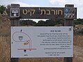
Cross shaped columbarium Signpost showing description of ancient ruin, Hurvat Qayit
The ancient ruin of Qayit, near Nehusha
Ruin of Qayit near Moshav Nehusha
Ruin of Qayit near Nehusha
References
^ ab"Regional Statistics". Israel Central Bureau of Statistics. Retrieved 21 March 2024.
^Carta's Official Guide to Israel and Complete Gazetteer to all Sites in the Holy Land. (3rd edition 1993) Jerusalem, Carta, p. 361, ISBN 965-220-186-3 (English)


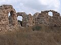 The ancient ruin of Qayit, near Nehusha
 Ruin of Qayit near Moshav Nehusha
 Ruin of Qayit near Nehusha


