Nepaug State Forest
State forest in Connecticut, US
41°50′16″N 72°57′27″W / 41.83778°N 72.95750°W / 41.83778; -72.95750[1]Nepaug State Forest is a Connecticut state forest located primarily in the town of New Hartford.[4]
Recreation opportunities
The forest offers hiking, biking, cross-country skiing, fishing, camping, letterboxing, and hunting. Trails that cross the forest include the blue-blazed Tunxis Trail.
Image gallery
-
 Nepaug State Forest's "Tunxis Trail" dirt road main entrance off CT-202 and parking lot.
 -
 Nepaug State Forest's backpacking camping area—rock campfire ring and very rustic log bench.
 -
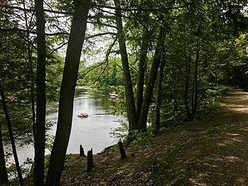 Farmington River Bank And River Road In Nepaug State Forest.
 -
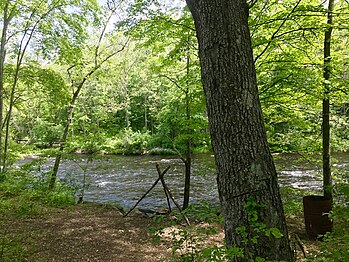 Farmington River Bank fishing spot in Nepaug State Forest.


References
- ^ a b "Nepaug State Forest". Geographic Names Information System. United States Geological Survey, United States Department of the Interior.
- ^ Legislative Program Review and Investigations Committee (January 23, 2014). "State Parks and Forests: Funding" (PDF). Staff Findings and Recommendations. Connecticut General Assembly. p. A-3. Retrieved March 20, 2014.
- ^ "Connecticut State Forests Seedling Letterbox Series - Clues for Nepaug State Forest". State Parks and Forests. Connecticut Department of Energy and Environmental Protection. Retrieved July 21, 2014.
- ^ "Nepaug State Forest". State Parks and Forests. Connecticut Department of Energy and Environmental Protection. Retrieved July 21, 2014.
External links
Wikimedia Commons has media related to Nepaug State Forest.
- Nepaug State Forest Connecticut Department of Energy and Environmental Protection
- Nepaug State Forest Camping Map Connecticut Department of Energy and Environmental Protection
- v
- t
- e
Protected areas of Connecticut
- Appalachian Trail
- New England National Scenic Trail
- Washington–Rochambeau Revolutionary Route
- Above All
- Air Line
- Beaver Brook
- Becket Hill State Park Reserve
- Beckley Furnace Industrial Monument
- Bennett's Pond
- Bigelow Hollow
- Black Rock
- Bluff Point
- Bolton Notch
- Brainard Homestead
- Burr Pond
- Camp Columbia
- Campbell Falls
- Chatfield Hollow
- Collis P. Huntington
- Connecticut Valley Railroad
- Dart Island State Park
- Day Pond
- Dennis Hill
- Devil's Hopyard
- Dinosaur
- Eagle Landing
- Farm River
- Farmington Canal
- Fort Griswold Battlefield
- Fort Trumbull
- Gardner Lake
- Gay City
- George Dudley Seymour
- George Waldo
- Gillette Castle
- Haddam Island
- Haddam Meadows
- Haley Farm
- Hammonasset Beach
- Harkness Memorial
- Haystack Mountain
- Higganum Reservoir
- Hop River State Park Trail
- Hopemead
- Hopeville Pond
- Horse Guard
- Housatonic Meadows
- Humaston Brook
- Hurd
- Indian Well
- John A. Minetto
- Kent Falls
- Kettletown
- Killingly Pond
- Lake Waramaug
- Lamentation Mountain
- Larkin State Park Trail
- Lovers Leap
- Macedonia Brook
- Machimoodus
- Mansfield Hollow
- Mashamoquet Brook
- Mianus River
- Millers Pond
- Minnie Island
- Mohawk Mountain
- Mono Pond
- Moosup Valley State Park Trail
- Mooween
- Mount Bushnell
- Mount Riga
- Mount Tom
- Old Furnace
- Osbornedale
- Penwood
- Platt Hill
- Pomeroy
- Putnam Memorial
- Quaddick
- Quinebaug Lake
- Quinnipiac River
- River Highlands
- Rocky Glen
- Rocky Neck
- Ross Pond
- Salt Rock State Campground
- Satan's Kingdom State Recreation Area
- Scantic River
- Selden Neck
- Seth Low Pierrepont
- Sherwood Island
- Silver Sands
- Sleeping Giant
- Southford Falls
- Squantz Pond
- Stillwater Pond
- Stoddard Hill
- Stratton Brook
- Sunnybrook
- Sunrise
- Talcott Mountain
- Tri-Mountain
- Trout Brook Valley
- Wadsworth Falls
- West Rock Ridge
- Wharton Brook
- Whittemore Glen
- Windsor Locks Canal State Park Trail
- Windsor Meadows
- Wooster Mountain
- Algonquin
- American Legion
- Centennial Watershed
- Cockaponset
- Enders
- James L. Goodwin
- Housatonic
- Massacoe
- Mattatuck
- Meshomasic
- Mohawk
- Mohegan
- Nassahegon
- Natchaug
- Nathan Hale
- Naugatuck
- Nehantic
- Nepaug
- Nipmuck
- Nye-Holman
- Pachaug
- Paugnut
- Paugussett
- People's
- Pootatuck
- Quaddick
- Salmon River
- Shenipsit
- Topsmead
- Tunxis
- Wyantenock
- Aldo Leopold WMA
- Assekonk WMA
- Babcock Pond WMA
- Barber Pond WMA
- Barn Island WMA
- Bartlett Brook WMA
- Bear Hill WMA
- Belding WMA
- Bishops Swamp WMA
- Black Pond WMA
- Candlewood Hill WMA
- Cedar Swamp WMA
- Charles E. Wheeler WMA
- Cromwell Meadows WMA
- Durham Meadows WMA
- East River Marsh WMA
- East Swamp WMA
- Eightmile River WMA
- Franklin Swamp WMA
- Goshen WMA
- Great Harbor WMA
- Higganum Meadows WMA
- Housatonic River WMA
- King's Island Coop WMA
- Kollar WMA
- Larson Lot WMA
- Little River Fish and Wildlife Area
- Lord's Cove WMA
- Maromas Coop WMA
- Meadow Brook WMA
- Menunketesuck WMA
- Messerschmidt WMA
- Newgate WMA
- Nod Brook WMA
- Nott Island WMA
- Pease Brook WMA
- Plum Bank WMA
- Quinebaug River WMA
- Quinnipiac River Marsh WMA
- Ragged Rock WMA
- Raymond Brook Marsh WMA
- Robbins Swamp WMA
- Roger Tory Peterson Wildlife Area
- Roraback WMA
- Rose Hill WMA
- Ross Marsh WMA
- Salmon River Cove and Haddam Neck WMA
- Sessions Woods WMA
- Simsbury WMA
- Skiff Mountain Coop WMA
- James V. Spignesi WMA
- Stanley Works WMA
- Suffield WMA
- Talbot WMA
- Tankerhoosen WMA
- Wangunk Meadows WMA
- Wopowog WMA
- Zemko Pond WMA
- Aspetuck Reservoir
- Barkhamsted Reservoir
- Beaver Dam Lake
- Candlewood Lake
- Easton Reservoir
- Far Mill Reservoir
- Hemlock Reservoir
- Hop Brook Lake
- Lake Lillinonah
- Mansfield Hollow Lake
- Means Brook
- Saugatuck Reservoir
- Trap Falls Reservoir
- West Hartford Reservoir
- West Pequonnock Reservoir
- Lake Zoar
- Aspetuck Land Trust
- Aton Forest
- Audubon Center at Bent of the River
- Bartlett Arboretum and Gardens
- Bear Mountain
- Beckley Bog
- Branford Land Trust
- Case Mountain
- Cathedral Pines
- Connecticut Audubon Society Center at Fairfield
- Connecticut College Arboretum
- Devil's Den Preserve
- Earthplace
- Great Mountain Forest
- Higby Mountain
- Highstead Arboretum
- Joshua's Tract Conservation and Historic Trust
- McLean Game Refuge
- New Canaan Nature Center
- Peter's Rock
- Pine Mountain Reserve
- Saltonstall Mountain
- Stamford Museum & Nature Center
- Steep Rock Association
- Weantinoge Heritage Land Trust
- White Memorial Foundation
- Woodcock Nature Center
- Yale-Myers Forest
- American Legion State Forest Trails
- Aspetuck Valley Trail
- Blue-Blazed Trails
- Chatfield Trail
- Hancock Brook Trail
- Housatonic Range Trail
- Lillinonah Trail
- Mattabesett Trail
- Menunkatuck Trail
- Metacomet Trail
- Narragansett Trail
- Natchaug Trail
- Naugatuck Trail
- Nehantic Trail
- Nipmuck Trail
- Paugussett Trail
- Pequot Trail
- Quinnipiac Trail
- Regicides Trail
- Salmon River Trail
- Shenipsit Trail
- Tunxis Trail
- Westwoods Trails
- Whitestone Cliffs Trail
- Zoar Trail
Forest/Parks
- Bear Mountain Reservation
- Beardsley Park
- Burr Farm Protected Open Space
- East Rock Park
- Gurski Farm Protected Open Space
- Happy Landings Protected Open Space
- Lighthouse Point Park
- Lillinonah Woods
- Mill River Park
- Old Bridge Sanctuary
- Pleasure Beach
- Roosevelt Forest
- Salt Meadow Park
- Seaside Park
- Webb Mountain Discovery Zone
- Webb Mountain Park


