Neptune Road
Road in Boston, Massachusetts
42°22′43″N 71°0′24″W / 42.37861°N 71.00667°W / 42.37861; -71.00667 Neptune Road is located in the East Boston neighborhood of Boston, Massachusetts.[1] The road is fragmented, bisected by the Massachusetts Bay Transportation Authority's Blue Line which surfaces from the subway southwest of the road. Much of the portion southeast of the train tracks is encompassed within Logan International Airport.
History

Neptune Road once was a residential street that also served as the entrance to Frederick Law Olmsted's Wood Island Park, a 47-acre waterfront park designed by Olmsted in the 19th century. An elegant tree-lined road with center islands, The Boston Globe referred to the street as a “miniature Commonwealth Avenue”.[2]
The expansion of Logan Airport in the late 1960s and early 1970s displaced families along Neptune Road, which is now used for warehouses and rental car property. As the airport expanded, planes flew in low over the residential blocks and conflicts with airport officials escalated. Wood Island Park was leveled early one morning in 1967.[3] On April 23, 1969, 35 workmen with 35 chain saws toppled 35 elms along the road. The Massachusetts Port Authority, under the reign of then-director and later Governor of Massachusetts Edward J. King, seized by eminent domain some 720 feet (220 m) of the street, and evicted families with the help of US Marshals.[2]
The airport has since implemented four "airport edge buffers," which include parks and greenery.[4] Some of Boston's last surviving elm trees are still located on Neptune Road, resisting the Dutch elm disease that have felled most of the Boston-area elms in the 20th century.
See also
- East Boston
- Logan International Airport
- Massachusetts Port Authority
References
- ^ "City of Boston Street Book", City of Boston
- ^ a b "Final chapter in the taking of Neptune Road" The Boston Globe, City Weekly section page 1, April 27, 1997.
- ^ Dorothy Nelkin (1974). Jetport: The Boston Airport Controversy. Transaction Publishers. ISBN 9781412826846.
{{cite book}}:|work=ignored (help) - ^ "Airport Edge Buffer Project Planned for Neptune Road". MassPort. March 11, 2009. Archived from the original on 2013-07-28.
Image gallery
-
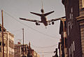 An American Airlines DC-10 comes in for landing at Logan International Airport over Neptune Road in East Boston in May, 1973.
 -
 An outbound Blue Line train (erroneously signed as "Boston") passes Neptune Road in 1967.
 -
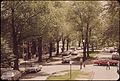
 Neptune Road and Frankfort Street. (May 1973)
 -
 Anthony Bruno affixes a protest sticker to the front door of his Neptune Road House while Joseph Porzio looks on. (May 1973)
 -
 MBTA tracks cut across Neptune Road. (May 1973)
 -
 Once Neptune Road led to Wood Island Park and the sea. Now it is bounded by a fence and the Logan Airport runway area. (May 1973)
 -
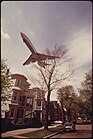 Jet zooms over southwestern side of Neptune Road. (May 1973)


External links
Wikimedia Commons has media related to Neptune Road.
- 40-Year-Old Images Show East Boston Grappling With an Expanding Logan Airport
- Ghosts of East Boston past and present
- East Boston Neighborhood Close to Destruction After 40 Year Fight
- The disappearance of Neptune Road | Looking Backward
- The final days of 18 Neptune Rd
- v
- t
- e
Streets and squares in Boston
- Beacon Street
- Boylston Street
- Commonwealth Avenue
- Congress Street
- Court Street
- Day Boulevard
- Dedham Parkway
- Fenway
- Gallivan Boulevard
- Huntington Avenue
- Melnea Cass Boulevard
- Milk Street
- Neptune Road
- New Chardon Street
- Newbury Street
- Park Street
- Soldiers Field Road
- State Street
- Storrow Drive
- Summer Street
- Tremont Street
- Winter Street

- Arborway
- Atlantic Avenue
- Blue Hills Parkway
- Bowdoin Street
- Brattle Street
- Brookline Avenue
- Charles Street
- Columbus Avenue
- Dorchester Avenue
- Enneking Parkway
- Federal Street
- Franklin Street
- Hanover Street
- Jamaicaway
- Jersey Street (Yawkey Way)
- Massachusetts Avenue
- Morrissey Boulevard
- Morton Street
- North Street
- Park Drive
- Riverway
- School Street
- Truman Parkway
- Turtle Pond Parkway
- Union Street
- Veterans of Foreign Wars Parkway
- Washington Street
- West Boundary Road
- West Roxbury Parkway
- Adams Square
- Andrew Square
- Blackstone Square
- Brigham Circle
- Central Square
- Chester Square
- City Square
- Cleveland Circle
- Codman Square
- Copley Square
- Day Square
- Dewey Square
- Dock Square
- Downtown Crossing
- Egleston Square
- Fields Corner
- Franklin Square
- Haymarket Square
- Hyde Square
- Jackson Square
- Kenmore Square
- Louisburg Square
- Mass and Cass
- Maverick Square
- Nubian Square (Dudley Square)
- Packard's Corner
- Park Square
- Peabody Square
- Post Office Square
- Roxbury Crossing
- Scollay Square
- Sullivan Square
- Thompson Square
- Union Square
- Uphams Corner
- Winthrop Square
- Italics denote streets and squares that no longer exist.


