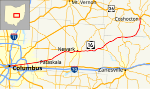
Ohio State Route 16
East-west state highway in Ohio, US
State Route 16 | ||||
|---|---|---|---|---|
 | ||||
| Route information | ||||
| Maintained by ODOT | ||||
| Length | 70.46 mi[1] (113.39 km) | |||
| Existed | 1926–present | |||
| Major junctions | ||||
| West end |  US 40 in Columbus US 40 in Columbus | |||
| Major intersections | ||||
| East end |  US 36 near Coshocton US 36 near Coshocton | |||
| Location | ||||
| Country | United States | |||
| State | Ohio | |||
| Counties | Franklin, Licking, Muskingum, Coshocton | |||
| Highway system | ||||
| ||||
| ||||
| ||||


State Route 16 (SR 16) is an east–west highway running from Columbus to Coshocton. Its western terminus is at Civic Center Drive (formerly U.S. Route 33) in Downtown Columbus, and its eastern terminus is at US 36. For much of its run through Licking County, and its entire run through Franklin County, State Route 16 follows the path of Columbus' Broad Street. West of Drexel Avenue in Bexley, the route is cosigned with U.S. Route 40 until its endpoint just east of the Scioto River.

History
The State Route 16 designation was originally applied to the routing carrying U.S. Route 422; when that route was created, SR 16 moved to the routing that had carried State Route 20. SR 16 was rerouted at its east end after the creation of US 36, then later truncated to Coshocton, with the eastern end becoming State Route 416.
Major intersections
| County | Location | mi[1] | km | Exit | Destinations | Notes |
|---|---|---|---|---|---|---|
| Franklin | Columbus | 0.00 | 0.00 |  US 40 west (Broad Street) / Civic Center Drive US 40 west (Broad Street) / Civic Center Drive | Western end of US 40 concurrency | |
| 0.32 | 0.51 |       US 23 south / US 33 east / US 62 west / SR 3 south (3rd Street) US 23 south / US 33 east / US 62 west / SR 3 south (3rd Street) | Western end of US 62 westbound concurrency | |||
| 0.41 | 0.66 |  US 23 north / US 33 west / US 62 / SR 3 north (4th Street) US 23 north / US 33 west / US 62 / SR 3 north (4th Street) | Western end of US 62 eastbound concurrency | |||
| 1.08– 1.14 | 1.74– 1.83 |     I-71 to I-670 west – Cincinnati, Cleveland I-71 to I-670 west – Cincinnati, Cleveland | Exit 108B (I-71) | |||
| 2.85 | 4.59 | US 62 east (Nelson Road) | Eastern end of US 62 concurrency | |||
| Bexley | 3.57 | 5.75 | US 40 east (Drexel Avenue) | Eastern end of US 40 concurrency | ||
| Whitehall | 6.97 | 11.22 |  SR 317 (Hamilton Road) SR 317 (Hamilton Road) | |||
| Columbus | 7.80– 8.31 | 12.55– 13.37 |  I-270 – Wheeling, W.Va., Cleveland I-270 – Wheeling, W.Va., Cleveland | Exit 39 (I-270) | ||
| Licking | Pataskala | 17.73 | 28.53 |   SR 310 south (South Main Street) to I-70 – Kirkersville SR 310 south (South Main Street) to I-70 – Kirkersville | Western end of SR 310 concurrency | |
| 17.84 | 28.71 | SR 310 north (Hazelton-Etna Road) / Township Road – Johnstown | Eastern end of SR 310 concurrency | |||
| Granville Township | 26.56– 26.65 | 42.74– 42.89 |    SR 37 west to SR 161 – Johnstown, New Albany, Granville SR 37 west to SR 161 – Johnstown, New Albany, Granville | Interchange, western end of SR 37 concurrency | ||
| 26.65 | 42.89 | Western end of freeway | ||||
| 26.87– 27.23 | 43.24– 43.82 | 27 |  SR 37 east / SR 661 – Granville, Lancaster SR 37 east / SR 661 – Granville, Lancaster | Interchange; eastern end of SR 37 concurrency; southern terminus of SR 661 | ||
| 27.60 | 44.42 | River Road (TR 131) | no access across SR 16 (right-in/right-out) | |||
| Granville–Newark line | 29.24– 29.94 | 47.06– 48.18 | 29[2] | Thornwood Crossing | ||
| Newark | 30.25 | 48.68 | 30 | Granville Road | Westbound exit only | |
| 30.49– 31.17 | 49.07– 50.16 | — | Country Club Drive / Church Street | Westbound entrance via West Church Street | ||
| 31.96– 32.27 | 51.43– 51.93 | — | North 21st Street | |||
| 32.50– 33.02 | 52.30– 53.14 | — |  SR 79 south – Heath SR 79 south – Heath | Western end of SR 79 concurrency | ||
| 32.93 | 53.00 | — | North 11th Street | Westbound exit; eastbound entrance | ||
| 33.27– 33.63 | 53.54– 54.12 | — |  SR 13 (South 4th Street / North Hudson Avenue) SR 13 (South 4th Street / North Hudson Avenue) | |||
| 34.07 | 54.83 | — | North Buena Vista Street | Former eastbound exit and westbound entrance; closed in 2012 | ||
| 34.39– 34.64 | 55.35– 55.75 | — | SR 79 north (North Cedar Street) – Nellie | Eastern end of SR 79 concurrency | ||
| 35.24– 35.55 | 56.71– 57.21 | — | O'Bannon Avenue | |||
| | 36.15– 39.45 | 58.18– 63.49 | At-grade intersections for 3.3 miles (5.3 km)[3] | |||
| Hanover Township | 43.12– 43.42 | 69.39– 69.88 |  SR 146 east / CR 273 (Toboso Road) – Hanover, Zanesville SR 146 east / CR 273 (Toboso Road) – Hanover, Zanesville | Western terminus of SR 146 | ||
| Muskingum | Jackson Township | 46.40– 46.94 | 74.67– 75.54 | 47 |  SR 586 – Mount Vernon, Frazeysburg, Zanesville SR 586 – Mount Vernon, Frazeysburg, Zanesville | |
| 51.15– 52.09 | 82.32– 83.83 | 52 | Old Riley Road – Frazeysburg | |||
| Cass Township | 55.46– 56.20 | 89.25– 90.45 | 56 |  SR 60 – Dresden, Zanesville, Warsaw SR 60 – Dresden, Zanesville, Warsaw | ||
| 57.08 | 91.86 | Eastern end of freeway | ||||
| Coshocton | Jackson Township | 67.16 | 108.08 |  SR 83 south – New Concord SR 83 south – New Concord | Western end of SR 83 concurrency | |
| Coshocton | 69.81– 70.06 | 112.35– 112.75 | 70 |  SR 541 (West Chestnut Street) – Roscoe Village, Coshocton SR 541 (West Chestnut Street) – Roscoe Village, Coshocton | ||
| Tuscarawas Township | 70.46 | 113.39 |  US 36 / SR 83 north to I-77 – Warsaw, Mount Vernon, Canal Lewisville US 36 / SR 83 north to I-77 – Warsaw, Mount Vernon, Canal Lewisville | Eastern end of SR 83 concurrency | ||
1.000 mi = 1.609 km; 1.000 km = 0.621 mi
| ||||||
References
KML file (edit • help)
Template:Attached KML/Ohio State Route 16
KML is from Wikidata
- ^ a b "DESTAPE". Ohio Department of Transportation. July 3, 2014. Retrieved October 4, 2014.
- Franklin County
- Licking County
- Muskingum County
- Coshocton County
- ^ ODOT District 5 on Facebook
- ^ Google (October 4, 2014). "Ohio State Route 16" (Map). Google Maps. Google. Retrieved October 4, 2014.
- v
- t
- e
 City of Columbus, Ohio
 Ohio portal
- Clintonville
- Downtown
- Arena District
- Capitol Square
- Civic Center
- Discovery District
- East Columbus
- Berwick
- Near East Side
- Driving Park
- Franklin Park
- King-Lincoln Bronzeville
- Mount Vernon
- Old Oaks
- Olde Towne East
- Woodland Park
- Northeast Columbus
- Argyle Park
- Linden
- Milo-Grogan
- Northland
- Forest Park
- Northwest Columbus
- Fifth by Northwest
- Flytown
- Harrison West
- Olentangy West
- South Columbus
- The Short North
- University District
- Glen Echo
- Northwood Park
- Old North Columbus
- Weinland Park
- West Side
- Briggsdale
- Cherry Creek
- Franklinton
- Georgian Heights
- Hilltop
- Holly Hill
- Murray Hill
- Riverbend
- Westgate
| Significant events |
|---|
| Historic sites |
|---|
| Organizations |
|---|
- Budd Dairy Food Hall
- Columbus Zoo and Aquarium
- KEMBA Live!
- Franklin Park Conservatory
- Greater Columbus Convention Center
- Hollywood Casino Columbus
- Lincoln Theatre
- Newport Music Hall
- North Market
- Ohio State Fair
- Ohio Theatre
- Palace Theatre
- Southern Theatre
- Topiary Park
| City buildings |
|---|
| County, state, and federal buildings |
|---|
| Schools |
|---|
| Libraries |
|
|---|
| Colleges and universities |
|---|
- Central Ohio Transit Authority
- CoGo Bike Share
- Historical: Union Station
- Toledo and Ohio station
- Columbus Bus Station
- Proposed: Columbus Streetcar
| Streets |
|---|
| Airports |
|---|
| Current teams |
|---|
| Former teams |
|
|---|
| Venues |
|
|---|
- Billy Ireland Cartoon Library & Museum
- Central Ohio Fire Museum
- Columbus Museum of Art
- COSI
- Jack Nicklaus Museum
- Kelton House Museum and Garden
- National Veterans Memorial and Museum
- Ohio History Center
- Ohio Statehouse
- Ohio Village
- Orton Geological Museum
- Pizzuti Collection
- Thurber House
- Wexner Center for the Arts
- Delaware, Fairfield, and Franklin Counties • Columbus metropolitan area • Ohio • United States
 | This Ohio road or road transport-related article is a stub. You can help Wikipedia by expanding it. |
- v
- t
- e


