Oosterzee
Village in Friesland, Netherlands
Oosterzee Eastersee | |
|---|---|
Village | |
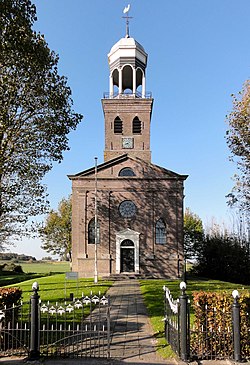 Oosterzee church | |
 Flag  Coat of arms | |
 Location in the former Lemsterlân municipality | |
52°52′28″N 5°46′23″E / 52.87444°N 5.77306°E / 52.87444; 5.77306 | |
| Country |  Netherlands Netherlands |
| Province |  Friesland Friesland |
| Municipality |  De Fryske Marren De Fryske Marren |
| Area [1] | |
| • Total | 15.62 km2 (6.03 sq mi) |
| Elevation [2] | −0.4 m (−1.3 ft) |
| Population (2021)[1] | |
| • Total | 930 |
| • Density | 60/km2 (150/sq mi) |
| Postal code | 8536[1] |
| Dialing code | 0514 |
Oosterzee (West Frisian: Eastersee) is a village in De Fryske Marren municipality in the province of Friesland, the Netherlands. It had a population of around 915 including surrounding area in 2017.[3]
History
The village was first mentioned in 1179 as Oesterze, and means eastern lake and is a reference to Tjeukemeer [nl].[4] Oosterzee was a road village which started in the Middle Ages as two settlements: Oosterzee-Buren and Oosterzee-Gietersebrug. From the 18th century onwards, peat excavation and poldering transformed the area into cultivated land.[5]
The Dutch Reformed Church was built in 1860 in the neoclassical style as a replacement of a medieval church which is located outside the village center.[5] In 1840, it was home to 880 people. In 1892, a dairy factory opened in Oosterzee, and closed in 1993. The factory was demolished in 2006 and replaced by a marina and a villa ward, however the chimney remains, because telecommunication companies used the chimney.[6]
Before 2014, Oosterzee was part of the Lemsterland municipality.[6] This municipality has since merged into De Fryske Marren municipality.
Gallery
-
 Village view
 -
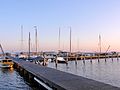 Marina of Oosterzee
 -
 Chimney of the former dairy factory
 -
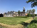
 Farms in Oosterzee


References
- ^ a b c "Kerncijfers wijken en buurten 2021". Central Bureau of Statistics. Retrieved 29 March 2022.
- ^ "Postcodetool for 8536TA". Actueel Hoogtebestand Nederland (in Dutch). Het Waterschapshuis. Retrieved 29 March 2022.
- ^ Kerncijfers wijken en buurten 2017 - CBS
- ^ "Oosterzee - (geografische naam)". Etymologiebank (in Dutch). Retrieved 29 March 2022.
- ^ a b Ronald Stenvert & Sabine Broekhoven (2000). "Oosterzee" (in Dutch). Zwolle: Waanders. ISBN 90 400 9476 4. Retrieved 29 March 2022.
- ^ a b "Oosterzee". Plaatsengids (in Dutch). Retrieved 29 March 2022.
External links
![]() Media related to Oosterzee at Wikimedia Commons
Media related to Oosterzee at Wikimedia Commons
- v
- t
- e
Populated places in the municipality of De Fryske Marren
- Joure
- Lemmer
- Sloten
- Former municipalities: Gaasterlân-Sleat
- Lemsterland
- Skarsterlân
- Akmarijp
- Bakhuizen
- Balk
- Bantega
- Boornzwaag
- Broek
- Delfstrahuizen
- Dijken
- Doniaga
- Echten
- Echtenerbrug
- Eesterga
- Elahuizen
- Follega
- Goingarijp
- Harich
- Haskerhorne
- Idskenhuizen
- Kolderwolde
- Langweer
- Legemeer
- Mirns
- Nijehaske
- Nijemirdum
- Oldeouwer
- Oosterzee
- Oudega
- Oudehaske
- Oudemirdum
- Ouwster-Nijega
- Ouwsterhaule
- Rijs
- Rohel
- Rotstergaast
- Rotsterhaule
- Rottum
- Ruigahuizen
- Scharsterbrug
- Sint Nicolaasga
- Sintjohannesga
- Snikzwaag
- Sondel
- Terherne
- Terkaple
- Teroele
- Tjerkgaast
- Vegelinsoord
- Wijckel
 | This Friesland location article is a stub. You can help Wikipedia by expanding it. |
- v
- t
- e


