Ord of Caithness
Headland in Scotland
58°8′22″N 3°36′15″W / 58.13944°N 3.60417°W / 58.13944; -3.60417
The Ord of Caithness is a granite mass on the east coast of the Highland council area of Scotland, on the boundary of the historic counties of Sutherland and Caithness. It is 2 miles (3.2 km) north-east of Helmsdale. It forms a headland 198 metres (650 ft) high, known as Ord Point. The A9 road passes above the Ord; there are sharp bends as it follows the contours.[1]
History
Historically, "the grim barrier of the Ord guaranteed its (i.e. Caithness's) isolation, and travellers who passed that way were greatly impressed by the experience."[2] It was described in the 1880s: "The old road over it, formerly the only land ingress to Caithness, traversed the crest of its stupendous seaward precipices at a height and in a manner most appalling to both man and beast... even the present road, formed in 1811... has very stiff gradients."[3]
Gallery
-
 Smiles 1878, Ord of Caithness
 -
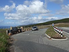 Ord of Caithness layby


References
External links
- Map sources for Ord of Caithness
Wikimedia Commons has media related to Ord of Caithness.
Portals:
 Scotland
 Geography

Purge


