Owenga
Rural settlement on Chatham Island, New Zealand
Place in Chatham Islands, New Zealand
Owenga | |
|---|---|
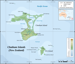 Chatham Island, with Owenga in the southeast | |
| Country |  New Zealand New Zealand |
| Territorial authority | Chatham Islands |
| Island | Chatham Island |
| Population | |
| • Total | 51 |
| Time zone | Chatham Standard Time Zone |
Owenga is a small settlement on Chatham Island, in New Zealand's Chatham Islands group.[1] It is the second easternmost settlement in New Zealand, after Flower Pot Bay on Pitt Island. It is located in the southeast of the island, close to Cape Fournier.
The Wharf at Owenga was built in 2010 and is the home of many fishing boats. It is also one of the main places to catch a fishing boat that may take you to Pitt Island. Owenga is one of the few settlements on the Chathams and has a fish factory, but no other shops.
References
- ^ administratorium. "Owenga Village – The Chatham Islands". Retrieved 22 July 2024.
- v
- t
- e
Chatham Islands
- Castle
- Chatham
- Forty-Fours
- Little Mangere
- Mangere
- North-East Reef
- Pitt
- Pyramid
- Rabbit
- Round Rock
- Sail Rock
- Sisters
- South East
- Star Keys
- Sugar Loaf

- Motuhope
- Motuhara/Motchuhar
- Rangatira
- Rangiauria
- Rangitatahi
- Rangituka
- Rangiwheau
- Rekohu/Wharekauri
- Tapuaenuku
- Tarakoikoia
- Terangi-Taumaewa
- Flowerpot Bay
- Owenga
- Port Hutt
- Te Roto
- Te One
- Waitangi
44°01′37″S 176°21′40″W / 44.027°S 176.361°W / -44.027; -176.361
 | This article about the geography of New Zealand's outlying islands is a stub. You can help Wikipedia by expanding it. |
- v
- t
- e


