Pandasan River
River in Sabah, Malaysia
| Pandasan River Pandassan River | |
|---|---|
 View of the river. | |
| Native name | Sungai Pandasan (Malay) |
| Location | |
| Country |  Malaysia Malaysia |
| State |  Sabah Sabah |
| Division | West Coast Division |
| Precise location | Northwestern Borneo |
| Physical characteristics | |
| Source | |
| • location | Stream |
| Mouth | |
• location | At Kota Belud District into South China Sea |
• coordinates | 6°28′7.28″N 116°32′4.41″E / 6.4686889°N 116.5345583°E / 6.4686889; 116.5345583 |
• elevation | Sea level |
The Pandasan River (Malay: Sungai Pandasan) is a stream located in Kota Belud, West Coast Division, northwestern Sabah of Malaysia.
History
This stream was where the boats of H.M.S. Iris was attacked by Illanoon pirates in 1846, during the British expedition to North Borneo to suppress piracy.[1]
While the stream is short, it once served as the northwest most extremities of Sulu sultanate influence in Borneo in the 19th century, and therefore appeared in the 1878 agreement,[2] that became point of contention in the North Borneo dispute.
-
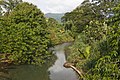 Pandasan river as viewed from the village of Pandasan

References
- ^ "1. Attack on the boats of H.M.S. Iris by the Illanoon Pirates in Pandassan River". Watercolour World. 20 February 2020.
- ^ British Government (1878). "British North Borneo Treaties. (British North Borneo, 1878)" (PDF). Sabah State Government (State Attorney-General's Chambers). Archived from the original (PDF) on 13 September 2015. Retrieved 24 February 2013.
- v
- t
- e
Physical geography of Sabah
| Bays | |
|---|---|
| Capes | |
| Islands |
|
| Peninsulas | |
| Straits |
| Caves | |||||
|---|---|---|---|---|---|
| Hills |
| ||||
| Mountains | |||||
| Mountain ranges | |||||
| Rivers |
| ||||
| Valleys | |||||
| Volcanic fields | |||||
| Waterfalls |
 | This article related to a river in Malaysia is a stub. You can help Wikipedia by expanding it. |
- v
- t
- e
 | This Sabah location article is a stub. You can help Wikipedia by expanding it. |
- v
- t
- e


