Plavnikovye Islands

The Plavnikovye Islands (Russian: острова Плавниковые; Ostrova Plavnikovyye) is a group of islands, in the Kara Sea eastern region, off the coast of Siberia. These islands are covered with tundra vegetation and there are many lakes and swamps. They are under snow and ice during most of the year.
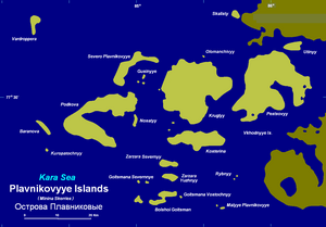
The largest islands of the Plavnikovye Archipelago are Pestsovy Island and Krugly Island. Most of these islands are located and less than 10 km west of the deeply indented shores of the Taymyr Peninsula. But others, like Vardroppera Island, are far offshore. The eastern group of islands, including Kosterina and Pestsovy, are also known as Vkhodnye Islands.
The Plavnikovye Islands, lie south of the small Kolosovykh peninsula. Geologically they are part of the Minina Skerries, a complex formation that includes the Kolosovykh Islands further north. This island group is located between 73° 15' and 74° 40' N and between 84° and 86° 30' E.
The sea surrounding the Plavnikovye Islands is covered with fast ice in the winter and the climate is severe, with bitter and long winters. The surrounding sea is obstructed by pack ice even in the summer.
This island group belongs to the Krasnoyarsk Krai administrative division of the Russian Federation. It is also part of the Great Arctic State Nature Reserve, the largest nature reserve of Russia.
The Plavnikovye Islands should not be confused with Plavnikovy Island (Ostrov Plavnikovy), off the western shores of Severnaya Zemlya, also in the Kara Sea.
References
- Nature Reserve: [1]
- Albert Hastings Markham. Arctic Exploration, 1895
- Armstrong, T., The Russians in the Arctic, London, 1958.
- Early Soviet Exploration: [2]
- History of Russian Arctic Exploration: [3]
See also
- Kara Sea
- Taymyr Peninsula
- v
- t
- e
 Islands of the Kara Sea (Russian Arctic)
- Arkticheskiy Institut Islands
- Belukha and Prodolgovaty
- Bely Island
- Bera Island
- Bolshoi Korsakovsky Islands
- Bonevi
- Dzhekman Islands
- Dikson Island
- Eastern Islands
- Firnley Islands
- Gavrilova
- Graham Bell Island
- Heiberg Islands
- Helland-Hansen Island
- Izvestiy TSIK Islands
- Kamennye Islands
- Kirov Islands
- Kolchak Island
- Kolomeytsev Islands
- Kolosovykh
- Komsomolets
- Krasnoflotskiye
- Krestovsky Island
- Krusenstern Islands
- Labyrintovye
- Ledyanyye Islands
- Levinson-Lessing Island
- Lishny
- Litke Islands
- Markgama
- Minina Skerries
- Mona Islands
- Moristy
- Myachina Islands
- Nablyudeniy
- Nansen Island
- Neupokoyeva
- Nordenskiöld Archipelago
- Nosok
- Novaya Zemlya
- October Revolution
- Oleniy
- Pakhtusov Islands
- Pilota Makhotkina
- Pioneer Island
- Plavnikovye
- Proklyatye
- Rastorguyev Island
- Russky Island
- Schmidt Island
- Scott Hansen Islands
- Sedov Archipelago
- Severnaya Zemlya
- Severny Island
- Shokalsky
- Shren Islands
- Sibiryakov Island
- Sorevnovaniya
- Storozhevye
- Sverdrup Island
- Taymyra
- Tillo Islands
- Tsivolko Islands
- Ushakov Island
- Uyedineniya
- Vaygach Island
- Vilkitsky Island
- Vilkitsky Islands
- Vize Island
- Voronina
- Yarzhinsky Islands
- Yermolov Island
- Yuzhny Island
- Zveroboy
74°10′N 85°15′E / 74.167°N 85.250°E / 74.167; 85.250
 | This Krasnoyarsk Krai location article is a stub. You can help Wikipedia by expanding it. |
- v
- t
- e


