Potonico
District in Chalatenango Department, El Salvador
District in Chalatenango Department, El Salvador

Flag

Seal

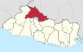
Location of Potonico within El Salvador
 El Salvador
Potonico is a district[3] in the Chalatenango department of El Salvador. Potonico is limited to the north by San Miguel de Mercedes, to the northwest by San Antonio Los Ranchos, to the east by San José Cancasque, to the southeast by Jutiapa, to the south and southwest by Cinquera, to the west and northwest by San Luis del Carmen. It's 44 km away from the national capital of San Salvador[4]. The district covers an area of 37.73 km² and the centre has an altitude of 260 m above sea level.
The toponym Potonico comes from the potón language and means "The Stone of Language". However, others assert its meaning is "Stinky Place" comes from the roots Potoni=stink, Co=place.[5]
References
- ^ https://www.listasal.info/municipios/chalatenango-sur.shtml
- ^ https://www.tse.gob.sv/
- ^ https://www.asamblea.gob.sv/node/12806
- ^ "Potonico, Chalatenango, El Salvador - Ciudades y pueblos del mundo". es.db-city.com (in Spanish). Retrieved 2024-09-11.
- ^ https://www.isdem.gob.sv/directorio-de-negocios/1015/potonico
- v
- t
- e
 Chalatenango Department Chalatenango Department | ||
|---|---|---|
Capital: Chalatenango | ||
| Municipalities |
|  |
| Geography | ||
| Landmarks |
| |


