Pujilí Canton
Canton in Cotopaxi Province, Ecuador
0°57′0″S 78°41′24″W / 0.95000°S 78.69000°W / -0.95000; -78.69000 Ecuador
 (2022 census)[1]
Pujilí Canton is one of seven cantons of the Cotopaxi Province in Ecuador. Its population at the 2001 census was 60,728.[2] Its capital is the town of Pujilí.
Subdivision
The canton is divided into seven parishes, one urban parish, Pujilí, and six rural ones:
- Angamarca
- Guangaje
- La Victoria
- Pílalo
- Tingo
- Zumbahua
-
 Pujilí
 -
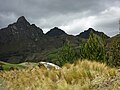 Mountains of Zumbahua
 -
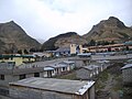 Zumbahua


Demographics
Ethnic groups as of the Ecuadorian census of 2010:[3]
- Indigenous 51.8%
- Mestizo 46.1%
- White 1.0%
- Afro-Ecuadorian 0.6%
- Montubio 0.5%
- Other 0.1%
Climate
| Climate data for Pílalo, elevation 2,500 m (8,200 ft), (1961–1990) | |||||||||||||
|---|---|---|---|---|---|---|---|---|---|---|---|---|---|
| Month | Jan | Feb | Mar | Apr | May | Jun | Jul | Aug | Sep | Oct | Nov | Dec | Year |
| Mean daily maximum °C (°F) | 15.8 (60.4) | 16.0 (60.8) | 16.0 (60.8) | 16.2 (61.2) | 16.6 (61.9) | 16.5 (61.7) | 16.7 (62.1) | 16.6 (61.9) | 16.7 (62.1) | 16.7 (62.1) | 16.5 (61.7) | 16.2 (61.2) | 16.4 (61.5) |
| Daily mean °C (°F) | 12.3 (54.1) | 12.5 (54.5) | 12.6 (54.7) | 12.8 (55.0) | 12.8 (55.0) | 12.5 (54.5) | 12.3 (54.1) | 12.3 (54.1) | 12.3 (54.1) | 12.5 (54.5) | 12.5 (54.5) | 12.3 (54.1) | 12.5 (54.4) |
| Mean daily minimum °C (°F) | 10.8 (51.4) | 9.1 (48.4) | 9.3 (48.7) | 9.1 (48.4) | 9.1 (48.4) | 8.6 (47.5) | 7.5 (45.5) | 8.0 (46.4) | 8.3 (46.9) | 8.6 (47.5) | 7.9 (46.2) | 8.8 (47.8) | 8.8 (47.8) |
| Average precipitation mm (inches) | 223.0 (8.78) | 257.0 (10.12) | 281.0 (11.06) | 186.0 (7.32) | 93.0 (3.66) | 44.0 (1.73) | 19.0 (0.75) | 16.0 (0.63) | 57.0 (2.24) | 119.0 (4.69) | 76.0 (2.99) | 112.0 (4.41) | 1,483 (58.38) |
| Source: FAO[4] | |||||||||||||
References
External links
- www.codeso.com / Map of Cotopaxi Province
- v
- t
- e
Cantons of Ecuador, by provincede los Tsáchilas
- Santo Domingo
- La Concordia
 Ecuador portal
 | This Ecuador location article is a stub. You can help Wikipedia by expanding it. |
- v
- t
- e


