Rackith
Stadtteil of Kemberg in Saxony-Anhalt, Germany
Location of Rackith

51°48′N 12°41′E / 51.800°N 12.683°E / 51.800; 12.683
(2006-12-31)
06901
Rackith is a village and a former municipality in Wittenberg district in Saxony-Anhalt, Germany. Since 1 January 2010, it is part of the town Kemberg.
Geography
Rackith lies about 12 km southeast of Lutherstadt Wittenberg.
Subdivisions
Rackith has two of these: Lammsdorf and Bietegast.
History
Rackith had its first documentary mention in 1004.
Economy and transportation
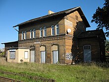
Federal Highway (Bundesstraße) B 182 between Wittenberg and Torgau runs right through the community. Rackith railway station lies on the single-track line between Wittenberg and Bad Schmiedeberg.
References
External links
- Verwaltungsgemeinschaft's website
Authority control databases | |
|---|---|
| International |
|
| National |
|
- v
- t
- e


