River Sid
River in Devon, England
50°42′00″N 3°12′00″W / 50.7000°N 3.2000°W / 50.7000; -3.2000
• location
• coordinates
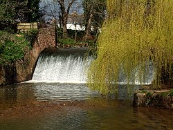
The River Sid, situated in East Devon, is often claimed to be the shortest complete river in England.[1] It flows for 6.5 miles (10.5 km) southwards from a source in Crowpits Covert (OSGB36 Grid reference SY138963) at a height of 206 metres above sea level.[2] The source is at the head of a goyle or small ravine.
The underlying geology is impermeable silty mudstones and sandstones of the Triassic Keuper marl, overlain with permeable Greensand and clay-with-flints. The junction between the Greensand and Keuper Marl forms a spring line.
The river flows through Sidbury and Sidford to Sidmouth and is fed by springs flowing from East Hill and water from the Roncombe Stream, the Snod Brook and the Woolbrook. In Sidmouth the river outflows at the Ham through a shingle bar.[3]
The Sid Vale Association, the first Civic Society in Britain (founded in 1846), is based in the Sid Vale.
References
- v
- t
- e
Ceremonial county of Devon
Devon Portal
- Plymouth
- Torbay
(cities in italics)
- Ashburton
- Axminster
- Bampton
- Barnstaple
- Bideford
- Bovey Tracey
- Brixham
- Buckfastleigh
- Budleigh Salterton
- Chagford
- Chudleigh
- Chulmleigh
- Colyton
- Crediton
- Cullompton
- Dartmouth
- Dawlish
- Exeter
- Exmouth
- Great Torrington
- Hatherleigh
- Holsworthy
- Honiton
- Ilfracombe
- Ivybridge
- Kingsbridge
- Kingsteignton
- Lynton
- Moretonhampstead
- Newton Abbot
- North Tawton
- Northam
- Okehampton
- Ottery St Mary
- Paignton
- Plymouth
- Plympton
- Plymstock
- Salcombe
- Seaton
- Sidmouth
- South Molton
- Tavistock
- Teignmouth
- Tiverton
- Topsham
- Torquay
- Totnes
See also: List of civil parishes in Devon
- Ashburn
- Avon
- Axe
- Barle
- Bovey
- Bray
- Burn
- Clyst
- Creedy
- Culm
- Dart
- East Dart
- West Dart
- Erme
- Exe
- Heddon
- Lemon
- Lew
- Lumburn
- Lyd
- East Lyn
- West Lyn
- Meavy
- Mole
- Okement
- East Okement
- West Okement
- Otter
- Plym
- Sid
- Swincombe
- Tamar
- Tavy
- Taw
- Teign
- Thrushel
- Torridge
- Walkham
- Wallabrooke
- East Webburn
- West Webburn
- Wolf
- Yealm
- Flag
- Devon County Council
- Parliamentary constituencies
- Economy
- Places
- Towns by population
- SSSIs
- Country houses
- Grade I listed buildings
- Grade II* listed buildings
- Scheduled monuments
- Bridges
- History
- Schools
- Museums
- Lord Lieutenants
- High Sheriffs
- Notable people
- Dartmoor
- Exmoor
- South Devon AONB
- Tamar Valley AONB
- Jurassic Coast
- South West Coast Path
- Two Moors Way
- North Devon's Biosphere Reserve
50°41′N 3°14′W / 50.683°N 3.233°W / 50.683; -3.233
 | This Devon location article is a stub. You can help Wikipedia by expanding it. |
- v
- t
- e
This article related to a river in England is a stub. You can help Wikipedia by expanding it. |
- v
- t
- e


