Shomera
Place in Northern, Israel
33°4′58″N 35°17′3″E / 33.08278°N 35.28417°E / 33.08278; 35.28417 (2022)[1]
Shomera (Hebrew: שׁוֹמֵרָה, lit. Guard) is a moshav in northern Israel. Located near the Lebanese border, it falls under the jurisdiction of Ma'ale Yosef Regional Council. In 2022 it had a population of 373.[1]
History

The moshav was established in 1949 by Jewish settlers from Hungary and Romania on the site of the Shia Palestinian village of Tarbikha. Its land had belonged to the Palestinian villages of Iqrit, Suruh and Tarbikha, all of which were ethnically cleansed by the Oded Brigade in the 1948 Arab–Israeli War during Operation Hiram.[2][3] The name reflects the moshav's proximity to the Lebanese border.[4]
The original residents abandoned the village shortly after its foundation, but the following year it was re-established by Jewish settlers from Morocco.[4]
An Israel Defense Forces armory is located in the moshav.
Gallery
-
 Tegart fort in Shomera.
 -
 A street in Shomera.
 -
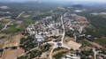 Shomera from a bird's eye view


References
- ^ a b "Regional Statistics". Israel Central Bureau of Statistics. Retrieved 21 March 2024.
- ^ Khalidi, W. (1992). All That Remains: The Palestinian Villages Occupied and Depopulated by Israel in 1948. Washington D.C.: Institute for Palestine Studies. pp. 17, 32, 34. ISBN 0-88728-224-5.
- ^ "Welcome To Iqrit - إقرت (איקרית)". Palestine Rememebred.
- ^ a b מושב שומרה RomGalil
Authority control databases | |
|---|---|
| International |
|
| National |
|


