Snydertown, New Jersey
Populated place in Hunterdon County, New Jersey, US
Unincorporated community in New Jersey, United States
40°23′55″N 74°50′02″W / 40.39861°N 74.83389°W / 40.39861; -74.83389 United States
 New Jersey
[1]
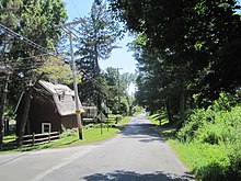
Snydertown is an unincorporated community located within East Amwell Township in Hunterdon County, in the U.S. state of New Jersey.[2] The settlement is located on the southern face of Sourland Mountain at the intersection of Linvale Road and Snydertown Road.[3] In the past, a mill operated in Snydertown.[4][5]
Historic district
The New Market–Linvale–Snydertown Historic District encompassing the community was added to the National Register of Historic Places in 1998 for its significance in architecture, commerce, settlement, and community development.[6][7]
References
- ^ a b "Snydertown". Geographic Names Information System. United States Geological Survey, United States Department of the Interior.
- ^ Locality Search, State of New Jersey. Accessed January 31, 2015.
- ^ Google (June 21, 2016). "Aerial view of Snydertown" (Map). Google Maps. Google. Retrieved June 21, 2016.
- ^ Snell, James P. (1881). History of Hunterdon and Somerset Counties, New Jersey. Philadelphia: Everts & Peck. p. 366. Retrieved June 21, 2016.
snydertown.
- ^ "Historic Photos". East Amwell Historical Society. Retrieved June 21, 2016.
- ^ "National Register Information System – (#98000097)". National Register of Historic Places. National Park Service. November 2, 2013.
- ^ Bertland, Dennis N. (June 1997). "National Register of Historic Places Inventory/Nomination: New Market–Linvale–Snydertown Historic District". National Park Service. With accompanying 26 photos
External links
 Media related to Snydertown, New Jersey at Wikimedia Commons
- v
- t
- e
Municipalities and communities of Hunterdon County, New Jersey, United States
County seat: Flemington

communities
- Allerton
- Amsterdam
- Anthony
- Baptistown
- Barbertown
- Barley Sheaf
- Bowne
- Bunnvale
- Byram
- Centerville
- Charlestown
- Cherryville
- Cloverhill
- Cokesbury
- Copper Hill
- Darts Mills
- Dreahook
- Everittstown
- Fairmount
- Grandin
- Hamden
- Headquarters
- Hoffmans
- Hughesville
- Jutland
- Lansdowne
- Larisons Corners
- Linvale
- Little York
- Lower Valley
- Mechanicsville
- Mount Airy
- Mount Pleasant
- Mountainville
- New Hampton
- Norton
- Pattenburg
- Penwell
- Perryville
- Pittstown
- Pleasant Run
- Potterstown
- Prallsville
- Quakertown
- Raven Rock
- Readingsburg
- Readington Village
- Reaville
- Rockefellows Mills
- Rosemont
- Rowland's Mills
- Sand Brook
- Sandy Ridge
- Sergeantsville
- Snydertown
- Spruce Run
- Stanton
- Tumble Falls
- Vanlieu Corners
- Van Syckel
- Wertsville
- West Portal
- Whitehouse
‡This populated place also has portions in an adjacent county or counties
- New Jersey portal
- United States portal
 | This Hunterdon County, New Jersey state location article is a stub. You can help Wikipedia by expanding it. |
- v
- t
- e


