Sokołowiec
Village in Lower Silesian Voivodeship, Poland
51°2′N 15°49′E / 51.033°N 15.817°E / 51.033; 15.817 Poland
Sokołowiec ([sɔkɔˈwɔvjɛt͡s]) (German: Falkenhain) is a village in the administrative district of Gmina Świerzawa, within Złotoryja County, Lower Silesian Voivodeship, in south-western Poland.[1]
It lies approximately 7 kilometres (4 mi) west of Świerzawa, 14 kilometres (9 mi) south-west of Złotoryja, and 87 kilometres (54 mi) west of the regional capital Wrocław.
Gallery
-
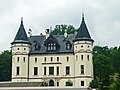 Palace in upper Sokołowiec
 -
 Ruin of a palace in central Sokołowiec
 -
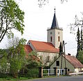 Saint Hedwig church
 -
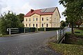 House by the road


References
- ^ "Central Statistical Office (GUS) – TERYT (National Register of Territorial Land Apportionment Journal)" (in Polish). 2008-06-01.
Wikimedia Commons has media related to Sokołowiec, Lower Silesian Voivodeship.
- v
- t
- e
Gmina Świerzawa
- Świerzawa

- Biegoszów
- Bronków
- Dobków
- Dynowice
- Gozdno
- Janochów
- Jurczyce
- Krzeniów
- Lubiechowa
- Nowy Kościół
- Podgórki
- Posępsko
- Różana
- Rząśnik
- Rzeszówek
- Sądrecko
- Sędziszowa
- Sokołowiec
- Stara Kraśnica
- Szczechów
 | This Złotoryja County location article is a stub. You can help Wikipedia by expanding it. |
- v
- t
- e


