Soroti–Amuria–Abim–Kotido Road
Road in Uganda
| Soroti–Amuria–Abim–Kotido Road | |
|---|---|
| Route information | |
| Length | 119 mi (192 km) |
| History | Designation TBD Expected completion TBD |
| Major junctions | |
| South end | Soroti |
| Major intersections | Amuria Abim |
| North end | Kotido |
| Location | |
| Country | Uganda |
| Highway system | |
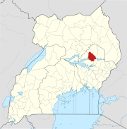
Soroti–Amuria–Abim–Kotido Road is a road in the Eastern and Northern Regions of Uganda. The road connects the towns of Soroti in Soroti District, to Amuria in Amuria District, Abim in Abim District, and Kotido, in Kotido District. Soroti and Amuria lie in the Teso sub-region, while Abim and Kotido are in the Karamoja sub-region.[1]
Location
The road starts at Soroti and continues north through Amuria and Abim, to end at Kotido, a distance of approximately 192 kilometres (119 mi).[2] The coordinates of the road near Abim are 2°43'38.0"N, 34°39'51.0"E (Latitude:2.727237; Longitude:33.664159).[3]
Overview
The road is gravel surface and in poor physical state. It is prone to flooding, and, when it does, it adversely disrupts travel between Soroti and Kotido.[4][5][6]
Upgrading to bitumen
During a campaign speech on 2 December 2015, President Yoweri Museveni stated that this road is among the next batch of roads to be considered for upgrading to grade II bitumen surface. No specific timetable has been set.[7]
See also
References
- ^ Vision Reporter (22 September 2011). "Motorists angry over Kotido road". New Vision. Kampala. Retrieved 9 February 2016.
- ^ GFC (9 February 2016). "Distance between Soroti, Eastern Region, Uganda and Kotido, Northern Region, Uganda". Globefeed.com (GFC). Retrieved 9 February 2016.
- ^ "Location of Soroti–Amuria–Abim–Kotido Road Near Abim" (Map). Google Maps. Google. 9 February 2016. Retrieved 9 February 2016.
- ^ Ariong, Steven (15 August 2011). "Movement affected as rains cut off Karamoja roads". Daily Monitor Mobile. Kampala. Retrieved 9 February 2016.
- ^ Edyegu, Daniel (6 November 2011). "Floods hit Eastern Uganda". New Vision. Kampala. Retrieved 9 February 2016.
- ^ Ebele, Stanley (9 December 2015). "El-Nino Rains Cut off Access to Karamoja". Kampala: Uganda Radio Network. Retrieved 9 February 2016.
- ^ YKMPC 2016 (2 December 2015). "President campaigns in Orungo, stresses roads and power". Kampala: Yoweri Museveni 2016 Presidential Campaign (YKMPC 2016). Retrieved 9 February 2016.
{{cite web}}: CS1 maint: numeric names: authors list (link)
External links
- Uganda National Road Authority Homepage
- Ugandan Government Increases Road Network Funding
- v
- t
- e

Capital: Soroti
villages
- Absa Bank Uganda
- Centenary Bank
- DFCU Bank
- PostBank Uganda
- Stanbic Bank
- Finance Trust Bank
- Opportunity Bank Uganda
- Pride Microfinance Limited
- National Social Security Fund
- Pela Commodities
- Soroti Fruit Processing Factory
- Soroti Airport
- Soroti Railway Station
- Soroti–Dokolo–Lira Road
- Tororo–Mbale–Soroti Road
- Soroti–Amuria–Abim–Kotido Road
- Soroti–Katakwi–Moroto–Lokitanyala Road
- Soroti Regional Referral Hospital
- Lwala Soroti Hospital
- Princess Diana Memorial Hospital
- 88.4 FM Voice of Teso Radio
landmarks
- Soroti Central Market
- Soroti Rock
- Roman Catholic Diocese of Soroti
- Landmark Hotel
- Soroti Hotel
- Akello Hotel
| ||
|---|---|---|
Capital: Amuria | ||
| Counties and sub-counties |
|  |
| Towns and villages | ||
| Transport |
| |
| Notable landmarks |
| |
| Notable people | ||
| ||
|---|---|---|
Capital: Abim | ||
| Towns and villages | 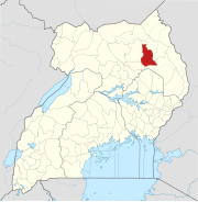 | |
| Economy |
| |
| Health | ||
| Transport |
| |
| ||
|---|---|---|
Capital: Kotido | ||
| Towns and villages |  | |
| Economy |
| |
| Notable landmarks | ||
| Health |
| |
| Transport |
| |
| Education |
| |
02°43′38″N 33°39′51″E / 2.72722°N 33.66417°E / 2.72722; 33.66417


