Strmec, Idrija
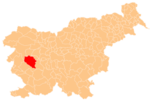
Place in Inner Carniola, Slovenia
45°54′30.83″N 14°1′25.46″E / 45.9085639°N 14.0237389°E / 45.9085639; 14.0237389 Slovenia
 (2002)
Strmec (pronounced [ˈstəɾməts], in older sources also Strmica,[2] German: Stermza[2]) is a small dispersed settlement in the hills south of Črni Vrh in the Municipality of Idrija[3] in the traditional Inner Carniola region of Slovenia.[2]
Strmec belongs to the cadastral municipality of Kanji Dol. Strmec has 12 numbered houses with traditional oeconyms: pri Šemrl (or Vodnar; no. 1), Tič (no. 2), Cenck (no. 3), Medved (no. 4), Podobnik (no. 5), Peter (no. 6), Skokec (no. 7), Štorc (no. 8), Skalar (no. 9), Renk (no. 10), Zajc (no. 11), and Strmec (no. 12). The Skalar house is now in ruins and it is no longer officially numbered. It was assigned number 8 c. 1823, but was reassigned the number 9 in 1959.
Gallery
-
 Podobnik hayrack, Strmec 5, 1959
 -
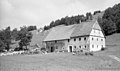
 Peter farm, Strmec 6
 -
 Skokec farm, Strmec 7
 -
 Štorc farm, Strmec 8
 -
 Skalar house, Strmec 9, 1959
 -
 Zajec house, Strmec 11, 1959


References
External links
- Strmec on Geopedia
- v
- t
- e
Municipality of Idrija
Administrative seat: Idrija
| Current |
|
|---|---|
| Former |
- Črni Vrh Observatory
- Holy Trinity Church
- Gewerkenegg Castle
- Idrija Lace School
- Idrija Mine
- Idrija Museum
- Idrijca River
- Kenda Manor
- Mary on the Rock Parish Church
- St. Joseph's Parish Church
- Vojko's Plaque
- Wild Lake


