Tarica District
District in Ancash, Peru
Tarica | |
|---|---|
District | |
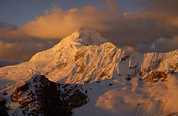 Tuqllarahu on the eastern border of the district | |
| Country |  Peru Peru |
| Region | Ancash |
| Province | Huaraz |
| Founded | February 2, 1956 |
| Capital | Tarica |
| Government | |
| • Mayor | Fredy Hildo Chinchay Salazar |
| Area | |
| • Total | 110.28 km2 (42.58 sq mi) |
| Elevation | 2,802 m (9,193 ft) |
| Population (2005 census) | |
| • Total | 5,500 |
| • Density | 50/km2 (130/sq mi) |
| Time zone | UTC-5 (PET) |
| UBIGEO | 020112 |
Tarica District is one of twelve districts of the province Huaraz in Peru.[1]
Geography
The Cordillera Blanca traverses the district. Some of the highest peaks of the district are Ranrapallqa, and Tuqllarahu. Other mountains are listed below:[2]
- Hatun Kunka
- Uqshapallqa
- Yanarahu
Ethnic groups
The people in the district are mainly indigenous citizens of Quechua descent. Quechua is the language which the majority of the population (68.31%) learnt to speak in childhood, 31.53% of the residents started speaking using the Spanish language (2007 Peru Census).[3]
References
- ^ (in Spanish) Instituto Nacional de Estadística e Informática. Banco de Información Distrital Archived 2008-04-23 at the Wayback Machine. Retrieved April 11, 2008.
- ^ escale.minedu.gob.pe - UGEL map of the Huaraz Province (Ancash Region)
- ^ inei.gob.pe Archived 2013-01-27 at the Wayback Machine INEI, Peru, Censos Nacionales 2007, Frequencias: Preguntas de Población: Idioma o lengua con el que aprendió hablar (in Spanish)
- v
- t
- e

8°36′00″S 77°46′01″W / 8.60000°S 77.76694°W / -8.60000; -77.76694
 | This Ancash Region geography article is a stub. You can help Wikipedia by expanding it. |
- v
- t
- e


