Tornado outbreak of March 13–15, 2024
Early-season tornado outbreak in Southern United States
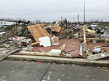
 EF3-rated tornado damage in Winchester, Indiana | |
| Tornado outbreak | |
|---|---|
| Tornadoes | 33 |
| Maximum rating | EF3 tornado[1] |
| Duration | March 13–15, 2024 |
| Highest winds | 165 mph (Winchester, Indiana on March 14) |
| Overall effects | |
| Fatalities | 4 |
| Injuries | 69 |
| Damage | $5.9 billion (2024 USD)[2] |
| Areas affected | Midwestern, Southern, Northeastern United States |
Part of the Tornadoes of 2024 | |
A significant early spring tornado outbreak occurred throughout the Midwestern and Northeastern United States, with the most significant impacts occurring in Indiana and Ohio. More than two dozen tornadoes occurred, eight of them strong to intense. National Weather Service offices issued multiple 'Particularly Dangerous Situation' tornado warnings. Strong tornadoes produced major damage in the communities of Selma and Winchester in Indiana, and Fryburg and Lakeview in Ohio. One person died in Winchester, and three people were killed in Lakeview. Other significant tornadoes caused damage in Kansas, Arkansas, and Kentucky, with scattered weak tornadoes confirmed in several other states.
In addition to tornadoes, severe weather occurred across the West and East South Central U.S. Damaging winds and large hail was reported in Oklahoma, Missouri, and parts of the Deep South. Heavy rainfall and flash flooding was reported in Tennessee and Kentucky.
Meteorological synopsis

The weather system responsible for the outbreak was evident multiple days prior, but the area that received the worst tornadoes was not expected to be the main threat. On March 9, the Storm Prediction Center (SPC) highlighted a 15% probability area of severe weather on March 14 for areas in northeast Texas and far southeast Oklahoma, indicating numerical weather models agreed that severe weather would occur.[3] Over the following days, model runs began to highlight favorable parameters for severe weather, mainly towards very large hail, damaging winds, and a potential for tornadoes across a corridor that expanded northeast.
On March 11, a Day 3 marginal risk was highlighted from central Oklahoma into eastern Kansas, as well as the Lower Missouri Valley. Forecasters identified deep troughing, as well as possible zonal flow, especially around southeast Kansas for March 13.
On March 12, a Day 3 slight risk was issued for the March 14 event, extending into Arkansas, central Missouri, southeastern Iowa, and western Illinois.[4] Given moderate moisture, strong atmospheric buoyancy, and an unstable airmass ahead of convective initiation preceded by a warm front, supercells were possible, with a risk for all severe hazards. A slight risk was also issued for Day 2 around northeastern Kansas.[5]
By 3:54 p.m. CDT on the 13th, storms began to initiate along a warm front in eastern Kansas as forecast. A shortwave trough was also noted nearby on water vapor imagery, highlighting large-scale ascent favorable for all severe hazards. At around 6:00 p.m. CDT, storms began to mature, and an EF2 tornado produced near Alta Vista, Kansas. Following the tornado in Alta Vista, another EF2 produced in Rossville, before storms began to downtrend through the night.[5]
On March 14, a particularly favorable corridor for severe weather was placed along eastern Oklahoma, northwestern Arkansas, and southern Missouri, with intense supercells capable of tornadoes, damaging winds, and very large hail. The aforementioned area was given a level 3/enhanced risk for severe weather, with a 10% risk for EF2+ tornadoes situated mainly in the area within Oklahoma and Arkansas.[6] In this area, convective available potential energy (CAPE) values reached 2,500–3,000 J/kg, favorable wind shear was present, and elongated, curved hodograph values were expected, allowing any mature supercell to rotate.
During the early morning hours of March 14, the system produced severe weather across areas of Kansas to Ohio. After the initial storms passed, the atmosphere was predicted to stabilize, as the temperature gradient throughout experienced vertical mixing. Because of this, an elongated, wide corridor that extended into Indiana and western Ohio was given a 5% risk for tornadoes, however, the Storm Prediction Center noted that if supercells were able to develop in this region, they could be long-tracked. Supercells were able to develop by the late afternoon near west Indiana and began tracking east and southeast through Ohio, prompting a tornado watch for the states.
Confirmed tornadoes
| EFU | EF0 | EF1 | EF2 | EF3 | EF4 | EF5 | Total |
|---|---|---|---|---|---|---|---|
| 2 | 11 | 11 | 7 | 2 | 0 | 0 | 33 |
March 13 event
| EF# | Location | County / Parish | State | Start Coord. | Time (UTC) | Path length | Max width |
|---|---|---|---|---|---|---|---|
| EF2 | E of Alta Vista to NE of Volland | Wabaunsee | KS | 38°52′N 96°27′W / 38.87°N 96.45°W / 38.87; -96.45 (Alta Vista (Mar. 14, EF2)) | 00:45–01:15 | 8.14 mi (13.10 km) | 300 yd (270 m) |
| The tornado remained mostly over rural areas, causing low-end EF2 damage to hardwood trees and outbuildings.[7] | |||||||
| EF2 | WNW of Rossville | Shawnee | KS | 39°08′N 95°59′W / 39.13°N 95.98°W / 39.13; -95.98 (Rossville (Mar. 14, EF2)) | 01:27–01:46 | 4.94 mi (7.95 km) | 100 yd (91 m) |
| Homes and outbuildings were damaged.[8] | |||||||
March 14 event
| EF# | Location | County / Parish | State | Start Coord. | Time (UTC) | Path length | Max width |
|---|---|---|---|---|---|---|---|
| EF1 | NW of Avon | Warren, Fulton | IL | 40°41′10″N 90°27′47″W / 40.686°N 90.463°W / 40.686; -90.463 (Avon (Mar. 14, EF1)) | 09:36–09:37 | 1.06 mi (1.71 km) | 150 yd (140 m) |
| A brief but high-end EF1 tornado damaged farmsteads. Outbuildings and machine sheds were destroyed, grain bins were damaged, trees were uprooted and power poles were snapped.[9] | |||||||
| EF0 | E of Fieldon to WNW of Delhi | Jersey | IL | 39°05′46″N 90°26′56″W / 39.096°N 90.449°W / 39.096; -90.449 (Fieldon (Mar. 14, EF0)) | 12:28–12:38 | 8.65 mi (13.92 km) | 100 yd (91 m) |
| Minor damage to trees, siding, and roofs occurred.[10] | |||||||
| EF0 | S of Fidelity | Jersey, Macoupin | IL | 39°08′13″N 90°11′13″W / 39.137°N 90.187°W / 39.137; -90.187 (Fidelity (Mar. 14, EF0)) | 12:44–12:48 | 3.9 mi (6.3 km) | 75 yd (69 m) |
| Minor damage to trees and farm buildings occurred.[11] | |||||||
| EF0 | Charlack | St. Louis | MO | 38°42′05″N 90°20′24″W / 38.7015°N 90.3399°W / 38.7015; -90.3399 (Charlack (Mar. 14, EF0)) | 12:46–12:47 | 0.1 mi (0.16 km) | 50 yd (46 m) |
| Minor damage to trees and houses occurred.[12] | |||||||
| EF0 | N of Birghton to SSE of Piasa | Jersey, Macoupin | IL | 39°04′16″N 90°09′07″W / 39.071°N 90.152°W / 39.071; -90.152 (Brighton (Mar. 14, EF0)) | 12:46–12:48 | 2.75 mi (4.43 km) | 200 yd (180 m) |
| Trees, outbuildings, and transmission lines were damage.[13] | |||||||
| EF0 | SW of Carlinville | Macoupin | IL | 39°13′52″N 89°56′28″W / 39.231°N 89.941°W / 39.231; -89.941 (Carlinville (Mar. 14, EF0)) | 12:58–13:00 | 2.13 mi (3.43 km) | 100 yd (91 m) |
| A farm building, tree limbs, and a residence were damaged.[14] | |||||||
| EF2 | N of Hanover, IN to Milton, KY to E of Carrollton, KY | Jefferson (IN), Trimble (KY), Carroll (KY), Switzerland (IN) | IN, KY | 38°44′09″N 85°28′28″W / 38.7359°N 85.4744°W / 38.7359; -85.4744 (Hanover (Mar. 14, EF2)) | 17:58–18:24 | 17.97 mi (28.92 km) | 500 yd (460 m) |
| This strong tornado formed near SR 256 on the north side of Hanover, causing minor EF1 damage to homes and trees. In Jefferson Manor subdivision several homes sustained roof damage; a newer house had its roof completely ripped off. Garages were heavily damaged, and an outbuilding was destroyed. The tornado then crossed SR 56, snapping trees before crossing the Ohio River into Kentucky, initially uprooting trees and damaging trees at high-end EF0 strength. The tornado reached EF1 intensity as it moved into the River Park Campground, where multiple trailers were flipped. The tornado then struck Milton, where damage to several homes, businesses, mobile homes, and trees was observed. It also moved over the Milton–Madison Bridge (US 421), although no damage to the bridge was reported. The tornado reached low-end EF2 intensity as it crossed KY 36 into Paradise Point, where campers and a motorhome were demolished. One tri-axle camper weighing well over 10,000 pounds (4.5 t) was rolled and thrown over 100 yd (91 m). After causing additional EF1 tree damage, the tornado briefly weakened, causing EF0 damage to trees as it crossed KY 1492 and KY 36. After moving over the Ohio River back into Ohio, the tornado quickly regained low-end EF2 intensity, knocking over and lifting several RV trailers along SR 56. Numerous boat ports had anchor supports pulled out of the ground and outbuildings and small barns were destroyed. In Switzerland County, more barns sustained significant EF1 roof damage. Extensive damage occurred to trees and power lines occurred in this area as well. The weakening tornado then crossed the Ohio River again back into Kentucky, causing minor EF0 tree damage before lifting along US 42. Two people were injured.[15] | |||||||
| EF0 | S of Hoffman | McIntosh | OK | 35°25′49″N 95°51′49″W / 35.4302°N 95.8635°W / 35.4302; -95.8635 (Hoffman (Mar. 14, EF0)) | 18:44–18:47 | 2.7 mi (4.3 km) | 350 yd (320 m) |
| The tornado developed just south of I–40, snapping large tree limbs and damaging an outbuilding.[16] | |||||||
| EF0 | NE of Ozark | Christian | MO | 37°01′44″N 93°10′26″W / 37.029°N 93.174°W / 37.029; -93.174 (Ozark (Mar. 14, EF0)) | 20:40–20:41 | 0.96 mi (1.54 km) | 50 yd (46 m) |
| Multiple trees were uprooted or snapped. A barn and outbuilding were also damaged.[17] | |||||||
| EF1 | ENE of New Corydon. IN to W of Celina, OH | Adams (IN), Mercer (OH) | IN, OH | 40°34′24″N 84°48′09″W / 40.5732°N 84.8025°W / 40.5732; -84.8025 (New Corydon (Mar. 14, EF1) | 22:40–22:55 | 9.34 mi (15.03 km) | 450 yd (410 m) |
| This tornado formed just west of the Indiana/Ohio state line, damaging trees, shingles, and an outbuilding within Indiana. In Ohio, damage to houses, trees and outbuildings occurred, with several outbuildings being completely destroyed. This was the first tornado produced by the Lakeview supercell.[18] | |||||||
| EF1 | Celina to NE of Moulton | Mercer, Auglaize | OH | 40°33′N 84°34′W / 40.55°N 84.57°W / 40.55; -84.57 (Celina (Mar. 14, EF1)) | 23:00–23:24 | 15.95 mi (25.67 km) | 1,050 yd (960 m) |
| This large, damaging high-end EF1 tornado began within the city of Celina and moved east, doing minor damage to trees and house roofs. The tornado crossed SR 29 and the circulation grew in size and strength, doing EF1-intensity damage to houses, trees, and outbuildings from west of St Marys to SR 116 east of US 33 north of the town. After this swath, the tornado steadily weakened while moving east, continuing for seven miles (11 km) before dissipating east of Wapakoneta.[19] | |||||||
| EFU | SW of Alvada | Hancock, Seneca | OH | 41°01′39″N 83°25′18″W / 41.0276°N 83.4217°W / 41.0276; -83.4217 (Alvada (Mar. 14, EFU)) | 23:09–23:12 | 1.29 mi (2.08 km) | 50 yd (46 m) |
| A brief tornado remained over open farmland, not impacting any structures.[20] | |||||||
| EF3 | W of Fryburg to Lakeview to SSW of West Mansfield | Auglaize, Logan | OH | 40°31′09″N 84°09′59″W / 40.5193°N 84.1664°W / 40.5193; -84.1664 (Fryburg (Mar. 14, EF3)) | 23:29–00:16 | 31.33 mi (50.42 km) | 1,000 yd (910 m) |
| 3 deaths – See section on this tornado – Twenty-seven people were injured. This was the third tornado produced by the Lakeview supercell.[21] | |||||||
| EF1 | S of Mt. Cory to SW of Jenera | Hancock | OH | 40°52′35″N 83°48′31″W / 40.8763°N 83.8087°W / 40.8763; -83.8087 (Mt. Cory (Mar. 14, EF1)) | 23:30–23:34 | 3.34 mi (5.38 km) | 100 yd (91 m) |
| Several homes and outbuildings were damaged.[22] | |||||||
| EF2 | ENE of Muncie to Selma to SSW of Parker City | Delaware | IN | 40°12′11″N 85°19′02″W / 40.203°N 85.3173°W / 40.203; -85.3173 (Selma (Mar. 14, EF2)) | 23:34–23:40 | 4.47 mi (7.19 km) | 175 yd (160 m) |
| A strong tornado passed through Selma. Manufactured homes and outbuildings were heavily damaged or destroyed, several homes suffered extensive damage, including some that had roofs torn off, and trees and utility poles were snapped. This storm would produce the Winchester EF3 tornado 10 minutes later.[23] | |||||||
| EF3 | S of Farmland, IN to Southern Winchester, IN to N of Covington, OH | Randolph (IN), Darke (OH), Miami (OH) | IN, OH | 40°10′43″N 85°07′30″W / 40.1785°N 85.1251°W / 40.1785; -85.1251 (Farmland (Mar. 14, EF3)) | 23:50–01:00 | 41.34 mi (66.53 km) | 700 yd (640 m) |
| 1 death – See section on this tornado – Thirty-nine people were injured.[1] | |||||||
| EF2 | ENE of New Washington to W of Shiloh | Crawford, Richland | OH | 40°58′37″N 82°50′09″W / 40.977°N 82.8358°W / 40.977; -82.8358 (New Washington (Mar. 14, EF2)) | 23:54–00:13 | 10.29 mi (16.56 km) | 250 yd (230 m) |
| Trees, power poles and homes were damaged in Auburn Township. The tornado then intensified, damaging multiple residences and outbuildings southwest of Plymouth. A single-wide manufactured home and an outbuilding were destroyed. The tornado then steadily weakened as it passed south of Plymouth, damaging homes and outbuildings, including one outbuilding that collapsed, and snapping trees and power poles before dissipating near Shiloh.[24] | |||||||
| EF0 | Northern Frisco | Collin | TX | 33°11′N 96°49′W / 33.19°N 96.81°W / 33.19; -96.81 (Frisco (Mar. 14, EF0)) | 23:59–00:00 | 0.2 mi (0.32 km) | 15 yd (14 m) |
| A brief tornado formed on the University of North Texas Frisco campus, damaging a few signs and shifting a car. The tornado exited campus and uprooted some young trees before dissipating.[25] | |||||||
| EF2 | NW of Raymond to Broadway to NE of Ostrander | Union, Delaware | OH | 40°22′18″N 83°31′30″W / 40.3718°N 83.5251°W / 40.3718; -83.5251 (West Mansfield (Mar. 14, EF2)) | 00:24–00:52 | 19.48 mi (31.35 km) | 600 yd (550 m) |
| This strong tornado touched down soon after the Lakeview EF3 tornado dissipated, becoming the fourth tornado produced by this supercell. It quickly strengthened and damaged several homes. A modular home was completely destroyed, with parts of it thrown downstream nearly half a mile. Another home lost a majority of its roof and had its exterior wall collapsed. More roof damage to homes and barns was observed, as well as considerable tree damage. The tornado then entered Delaware County, producing EF1 damage before dissipating.[26] | |||||||
| EF1 | N of Mount Vernon | Jefferson | IL | 38°20′40″N 88°55′03″W / 38.3445°N 88.9175°W / 38.3445; -88.9175 (Mt. Vernon (Mar. 14, EF1)) | 00:32–00:33 | 0.5 mi (0.80 km) | 150 yd (140 m) |
| Two metal buildings had most of their roofs removed and all their garage bay doors blown out. The buildings' exterior walls were partially removed. Several buses inside sustained significant damage from debris. Building material was pulverized and embedded in the ground and walls of buildings downwind. A nearby metal building also sustained roof damage. A few large hardwood trees were also uprooted.[27] | |||||||
| EF2 | Hot Springs Village | Garland, Saline | AR | 34°38′23″N 93°03′31″W / 34.6397°N 93.0587°W / 34.6397; -93.0587 (Hot Springs Village (Mar. 14, EF2)) | 00:57–01:19 | 8.53 mi (13.73 km) | 1,000 yd (910 m) |
| This large tornado formed just north of the Mountain Valley community along AR 7 where wooden utility poles were snapped, indicating EF2 strength with winds around 115 mph (185 km/h). It continued into Hot Springs Village, causing extensive tree damage consistent with EF2 winds, including snapped trunks and uprooted trees. In this area, homes were primarily damaged by falling trees rather than direct tornado winds. Beyond this point, the roof of a building along the bluff was blown off and thrown approximately 80 yd (73 m) to the northeast. The tornado began to weaken after this point, showing mainly EF1-level tree damage before lifting.[28] | |||||||
| EF1 | S of Delaware to S of Sunbury to S of St. Louisville | Delaware, Licking | OH | 40°15′36″N 83°04′04″W / 40.2599°N 83.0678°W / 40.2599; -83.0678 (Delaware (Mar. 14, EF1)) | 01:01–01:50 | 35.38 mi (56.94 km) | 600 yd (550 m) |
| A long-tracked EF1 tornado, the fifth and last tornado produced by the Lakeview supercell, developed on the west side of US 23, initially causing minor and sporadic tree damage. After crossing US 23 the tornado widened and began causing more structural damage, as houses were damaged, and barns were destroyed. The Olentangy Berlin High School sustained damage to parts of the school campus and athletic fields. Several transmission towers were felled nearby. The tornado then moved into neighborhoods southwest of Sunbury and west of Galena, causing widespread and significant tree damage and blowing out windows. Roofs were also partially removed, and power poles were snapped in the area. Galena itself sustained straight-line wind with embedded tornadic damage. More homes were damaged, and barns were destroyed before the tornado dissipated near SR 13.[29] | |||||||
| EF1 | NE of Fairfield to NNW of Golden Gate | Wayne | IL | 38°24′29″N 88°16′55″W / 38.408°N 88.282°W / 38.408; -88.282 (Fairfield (Mar. 14, EF1)) | 01:11–01:15 | 2.8 mi (4.5 km) | 75 yd (69 m) |
| A tornado inflicted roof damage to a home as soon as it formed. Moving east, an anchored mobile home was lifted and tipped over, sustaining major damage. Another home northeast of the mobile home had significant soffit and porch damage. An old TV tower was toppled on the property. Numerous pine trees were snapped along the tornado's path.[30] | |||||||
| EF0 | SE of Raymond | Breckinridge | KY | 37°55′40″N 86°21′18″W / 37.9278°N 86.3549°W / 37.9278; -86.3549 (Raymond (Mar. 14, EF0)) | 03:32–03:33 | 0.46 mi (0.74 km) | 20 yd (18 m) |
| A brief tornado overturned a small wood shed and a pile of aluminum housing trim was scattered. Several dead trees were uprooted as well.[31] | |||||||
| EF1 | N of Broken Bow | McCurtain | OK | 34°06′35″N 94°44′33″W / 34.1096°N 94.7424°W / 34.1096; -94.7424 (Broken Bow (Mar. 14, EF1)) | 04:00–04:01 | 0.47 mi (0.76 km) | 200 yd (180 m) |
| Trees and buildings were damaged by this QLCS tornado. Two homes suffered varying degrees of damage and some outbuildings were severely damaged. There was also roof damage observed to a single-family home and a hotel.[32] | |||||||
March 15 event
| EF# | Location | County / Parish | State | Start Coord. | Time (UTC) | Path length | Max width |
|---|---|---|---|---|---|---|---|
| EF1 | New Albany | Union | MS | 34°29′43″N 89°01′01″W / 34.4954°N 89.017°W / 34.4954; -89.017 (New Albany (Mar. 15, EF1)) | 08:13–08:15 | 0.85 mi (1.37 km) | 150 yd (140 m) |
| A tornado developed in New Albany causing intermittent tree damage. The tornado crossed the Little Tallahatchie River and moved into downtown where the police station was damaged. Deeper into town, numerous trees and structures were damaged, with the most significant damage being observed at the county clerk's office. The tornado caused additional roof damage before dissipating.[33] | |||||||
| EF1 | NE of Caledonia | Lowndes | MS | 33°42′37″N 88°17′35″W / 33.7102°N 88.293°W / 33.7102; -88.293 (Caledonia (Mar. 15, EF1)) | 10:04–10:09 | 2.05 mi (3.30 km) | 200 yd (180 m) |
| Trees were damaged and downed. Several outbuildings and the roof of a single family home sustained damage and a mobile home lost much of its roof.[34] | |||||||
| EF0 | NNW of Steens | Lowndes | MS | 33°36′25″N 88°19′53″W / 33.607°N 88.3313°W / 33.607; -88.3313 (Steens (Mar. 15, EF0)) | 10:07–10:08 | 0.64 mi (1.03 km) | 75 yd (69 m) |
| A brief tornado damaged the roof of a home, a carport and a few trees.[35] | |||||||
| EF0 | NW of Lakeview | DeKalb | AL | 34°25′07″N 85°58′35″W / 34.4187°N 85.9763°W / 34.4187; -85.9763 (Lakeview (Mar. 15, EF0)) | 11:53–11:54 | 0.19 mi (0.31 km) | 77 yd (70 m) |
| Roof panels were peeled off of a chicken house. A pole barn was pushed over and another barn sustained roof damage.[36] | |||||||
| EF1 | SW of Rochelle | McCulloch | TX | 31°10′24″N 99°13′57″W / 31.1734°N 99.2324°W / 31.1734; -99.2324 (Rochelle (Mar. 15, EF1)) | 14:07–14:09 | 0.02 mi (0.032 km) | 10 yd (9.1 m) |
| A metal barn was thrown onto a neighboring barn.[37] | |||||||
| EFU | SE of Pearlington | Hancock | MS | 30°12′N 89°32′W / 30.2°N 89.54°W / 30.2; -89.54 (Pearligton (Mar. 15, EFU)) | 18:35–18:37 | 0.6 mi (0.97 km) | 75 yd (69 m) |
| A brief tornado crossed the Pearl River on the Louisiana state line. A CSX bridge tender reported a snapped pine tree and railroad signs knocked over, but no damage could be found, and no rating could be applied.[38] | |||||||
Fryburg–Lakeview–Russells Point, Ohio
 Low-end EF3 damage north of Fryburg, Ohio | |
| Meteorological history | |
|---|---|
| Formed | March 14, 2024, 7:29 p.m. EDT (UTC−04:00) |
| Dissipated | March 14, 2024, 8:16 p.m. EDT (UTC−04:00) |
| Duration | 47 minutes |
| EF3 tornado | |
| on the Enhanced Fujita scale | |
| Highest winds | 155 mph (250 km/h) |
| Overall effects | |
| Fatalities | 3 |
| Injuries | 27 |
| Damage | $6 million (2024 USD) |
During the evening hours of March 14, a long-tracked, deadly, and destructive EF3 tornado directly impacted portions of northwest Ohio. The tornado initially formed just east of I-75 to the west of Fryburg and south of Wapakoneta in Auglaize County, at 7:29 p.m. EDT.[39] It tracked eastward, causing weak EF0 damage to a home and outbuilding on a farm and uprooted trees before beginning a rapid strengthening trend. It uprooted trees at EF1 intensity and then snapped trees at EF2 intensity before reaching low-end EF3 strength and impacting the Glacier Hill Lakes RV Resort. The main office of the resort, multiple homes, and dozens of RVs were completely destroyed, flipped, and tossed.[40] At least three people were injured in this area.[41] The tornado exited the resort to the east, strewing debris across a field and leaving cycloidal marks in the dirt while causing additional EF2 damage.[42] The tornado further weakened to EF1 intensity as it crossed Town Line Road and began to deviate to the east-southeast as it passed the community of Geyer and crossed SR 65. Damage along this segment of the path consisted of homes suffering roof damage, outbuildings being damaged or destroyed, power poles being snapped, and trees being uprooted or snapped. As it approached Logan County, it regained EF2 intensity and passed very near Sante Fe as it moved into the county, paralleling SR 720. It caused significant damage to multiple homes, damaged or destroyed more outbuildings, and trees, and power poles.[41][43][44][45] After destroying an outbuilding along Township Highway 84, the tornado reached EF3 strength again northwest of Lakeview, where large swaths of trees were uprooted and debarked. It also caused some damage to another outbuilding.[41]

Maintaining EF3 intensity, the tornado entered the western outskirts of Lakeview. Along Poplar Court, multiple homes sustained intense damage, including one home that was completely destroyed, with its subflooring ripped off. The tornado continued into the main portions of Lakeview. Hundreds of homes were completely destroyed, with a majority of the area consisting of manufactured homes. A storage facility was partially destroyed, the local library lost its roof, and multiple businesses along Main St were severely impacted.[46][47] Past the US 33/SR 235/SR 366 intersections, the tornado weakened some but remained strong at EF2 intensity as it began to parallel US 33 and SR 366 and struck a campground. It tracked directly through densely packed RVs at this location, flipping and obliterating almost every single one there.[48] Past there, the tornado tracked through multiple neighborhoods and mobile home parks in the eastern part of Lakeview, ripping roofs off of homes, damaging businesses, and heavily damaging or destroying many mobile homes and outbuildings. Much of the peak damage along this segment was rated EF2, although one destroyed business received a low-end EF3 rating. The National Weather Service indicated that over 45% of Lakeview was damaged or destroyed by the tornado. Additionally, flooding disrupted cleanup and rescue efforts after the storm.[49]
Past Lakeview, the tornado turned eastward and moved into the northwestern part of Russells Point at low-end EF2 intensity, unroofing homes and uprooting trees in a neighborhood along SR 366.[50] The tornado reached high-end EF2 intensity again as it crossed over a portion of Indian Lake and directly impacted the neighborhood of Orchard Island in north Russells Point. Devastation paralleled that of Lakeview, with dozens of RVs, mobile homes, and outbuildings being heavily damaged or destroyed, homes being severely damaged, and trees being snapped or uprooted, including at the Fox Island State Park. The tornado began to weaken as it crossed over another portion of Indian Lake before impacting homes in far east Russells Point. Homes near Dunns Pond were particularly devastated with damage to those homes rated EF2; the rest of the damage was rated EF1. The tornado then crossed SR 368 exited Russells Point to the east.[41][50]
The tornado then continued southeastward along SR 366 at EF1 intensity damaging homes and outbuildings. It then crossed SR 117 north of Huntsville, before flipping a truck along County Road 34 and damaging additional trees. The damage became much more sporadic as the tornado slowly weakened over rural areas east of Huntsville, damaging trees and outbuildings as it approached and crossed over both SR 274 and US 68.[44] After further weakening to EF0 strength southwest of Walnut Grove and crossing SR 47, the tornado dissipated just after crossing SR 292 west of West Mansfield at 8:16 p.m. EDT.[41][49][21]
In all, three people were killed and 27 were injured. Logan County Emergency Management Authorities issued a mass-casualty event.[51]
Winchester, Indiana/Bradford, Ohio
 High-end EF3 damage to Taco Bell restaurant in Winchester, Indiana. | |
| Meteorological history | |
|---|---|
| Formed | March 14, 2024, 7:50 p.m. EDT (UTC−04:00) |
| Dissipated | March 14, 2024, 9:00 p.m. EDT (UTC−04:00) |
| Duration | 70 minutes |
| EF3 tornado | |
| on the Enhanced Fujita scale | |
| Highest winds | 165 mph (266 km/h) |
| Overall effects | |
| Fatalities | 1 |
| Injuries | 39 |
| Damage | $26.25 million (2024 USD) |
This long-tracked and destructive high-end EF3 tornado first touched down south of Farmland, Indiana in Randolph County at 7:50 p.m. EDT, causing minor EF0 damage to a few homes and collapsing a barn. The tornado then moved into a cemetery where a few trees were uprooted, and a home was damaged at EF1 intensity. It then crossed SR 32 downing numerous power lines, and then started to cause ground scouring in the field across SR 32. The tornado continued east-southeast in the field causing more cycloidal ground-scouring and damaging a wind turbine blade at EF0 intensity. The tornado's eastward movement then became erratic as it made multiple sudden northward and southward turns, crossing SR 32 multiple times. A farmstead was completely destroyed with one home being pushed off its crawlspace and collapsed, although no rating was applied to this damage. An outbuilding at this farmstead was also destroyed. Approximately 40 power-poles were downed as the tornado moved along SR 32 and a roughly 3 miles (4.8 km) swath of intense ground-scouring occurred as the tornado approached the southwestern part of Winchester.[41]

Continuing on its erratic eastward trajectory, the tornado entered Winchester at high-end EF2 intensity. It tore through a subdivision with the worst damage localized along Englewood Drive. Dozens of poorly anchored homes sustained damage, with a few homes having their roofs torn off and exterior walls collapsed. The tornado continued east-southeast through southern Winchester, tearing the roofs off of many additional poorly-anchored homes at mid-range EF2 intensity. One home along Browne Street was reduced to its cinder-block foundation with a high-end EF2 rating being applied. The Randolph Nursing & Rehabilitation Center took a near direct hit at low-end EF2 intensity, sustaining partial roof loss with its debris being wind-rowed into a nearby field. Two vehicles at the center were thrown into this field as well. Other vehicles along this portion of the path were also moved or damaged and trees and power poles were damaged or snapped.[41]

The tornado then quickly intensified to low-end EF3 intensity as it crossed US 27 and struck a strip mall, which sustained exterior wall collapse with cars in adjacent parking lots also being damaged and moved. Right next to the strip mall, a small, but well-built Taco Bell structure was completely destroyed, with most of the debris being swept off the foundation. A few employees here took shelter in the freezer and survived. A high-end EF3 rating with wind speeds up to 165 mph (266 km/h) was applied to this structure. The tornado then weakened slightly, but remained at high-end EF3 intensity as it crossed East Greenville Pike and struck the Freedom Life Church, which was almost entirely flattened with only a small area of interior walls remaining. Wind speeds up to 155 mph (249 km/h) were estimated here. A small park was also hit, with the playground being completely destroyed, and a tree being heavily stubbed and debarked.[41]
The tornado then exited Winchester at a weaker, but still strong EF2 intensity and struck a farmstead, inflicting intense tree damage and unroofing a home. The tornado was still causing intense ground-scouring at this point, and this would continue to the Ohio state line. Many farmsteads were hit by the tornado, mainly at EF1-EF2 intensity with outbuildings being destroyed. Continuing its erratic eastward movement, the tornado passed south of the Randolph County Airport as it moved along Base Road. Three farmsteads east of the airport were completely destroyed at EF3 intensity, with their homes sustaining roof loss and exterior wall collapse. Continuing east, a few more farmsteads were struck, with one farmstead having its grain silos significantly damaged.[41]

The tornado then turned east-southeast and crossed into Darke County, Ohio before once again continuing its erratic eastward movement. In Darke County, several homes sustained roof damage at EF1 intensity, with two people being injured in Greenville Township. The tornado then crossed into Miami County passing just north of Bradford before briefly reaching EF2 intensity again. Two homes had their roofs torn off and exterior walls removed, with outbuildings sustaining significant damage. The tornado then quickly weakened and dissipated along SR 48, north of Covington at 9:00 p.m. EDT.[41]
A quick response team used to determine EF ratings possibly greater than EF3 was deployed to Winchester, but no EF4 damage was found by the team. In result, the tornado was rated as a high-end EF3 with winds estimated at 165 mph (266 km/h). It reached a peak width of 700 yards (640 m) in Indiana, and 250 yards (230 m) in Ohio. The tornado tracked for a total of 41.4 miles (66.6 km) across the two states, remaining on the ground for 70 minutes. There were 40 injuries; one person died from their injuries a month later.[1][41]
Non-tornadic effects
The system and the severe storms responsible for the tornado outbreak also produced widespread wind and hail damage over the Central Plains, Mississippi and Ohio valleys, and the Southeastern United States. Hailstones greater than 4.00 in (10.2 cm) in diameter fell in Ada, Oklahoma on March 14, including one hailstone with a diameter of 5.25 in (13.3 cm). Widespread wind and hail damage was reported throughout the Kansas City metropolitan area on March 13, while widespread hail damage was reported throughout the St. Louis metropolitan area on March 14 as well.[5] [52] Scattered wind and hail damage occurred south of Houston, Texas on March 15.[53]
The system also produced very heavy rainfall fell across parts of Tennessee, especially in the central part of the state, between March 14–15. Rainfall totals maxed out at 4.15 in (105 mm) in Leoma and 3.96 in (101 mm) in Hohenwald. The Nashville International Airport recorded 1.20 in (30 mm) of rain while nearby Joint Base Berry Field recorded 1.09 in (28 mm).[54] Two people needed to be rescued from a flooded creek in Lawrence County.[55]
Further west, snow from the storm system on March 13 led to roads on the eastern half of Rocky Mountain National Park closed.[56]
See also
Wikimedia Commons has media related to Tornado outbreak of March 13–15, 2024.
- List of North American tornadoes and tornado outbreaks
- Weather of 2024
- List of United States tornadoes from January to March 2024
Notes
- ^ a b c All dates are based on the local time zone where the tornado touched down; however, all times are in Coordinated Universal Time for consistency.
References
- ^ a b c The National Oceanic and Atmospheric Administration's finalized report by county:
- National Centers for Environmental Information; National Weather Service (June 20, 2024). "Indiana Event Report: EF3 Tornado (Randolph County)". Storm Events Database (Finalized report). Indianapolis. Indiana: National Oceanic and Atmospheric Administration. Archived from the original on June 21, 2024. Retrieved June 21, 2024.
- National Centers for Environmental Information; National Weather Service (June 20, 2024). "Ohio Event Report: EF1 Tornado (Darke County)" (Finalized report). Storm Events Database. Wilmington, Ohio: National Oceanic and Atmospheric Administration. Archived from the original on June 21, 2024. Retrieved June 21, 2024.
- National Centers for Environmental Information; National Weather Service (June 20, 2024). "Ohio Event Report: EF2 Tornado (Miami County)" (Finalized report). Storm Events Database. Wilmington, Ohio: National Oceanic and Atmospheric Administration. Archived from the original on June 21, 2024. Retrieved June 21, 2024.
- ^ National Centers for Environmental Information (April 2024). "U.S. Billion-Dollar Weather and Climate Disasters" (Press release). Events. Asheville, North Carolina, United States: National Oceanic and Atmospheric Administration. Archived from the original on April 15, 2024. Retrieved April 15, 2024.
- ^ "Day 4-8 Severe Weather Outlook Issued on Mar 9, 2023". Storm Prediction Center. Retrieved March 15, 2024.
- ^ "Mar 12, 2024 0730 UTC Day 3 Severe Thunderstorm Outlook". Storm Prediction Center. Retrieved March 15, 2024.
- ^ a b c "SPC Severe Weather Event Review for Wednesday March 13, 2024". www.spc.noaa.gov. Retrieved March 19, 2024.
- ^ "Mar 14, 2024 1300 UTC Day 1 Convective Outlook". Storm Prediction Center. Retrieved March 15, 2024.
- ^ National Weather Service in Topeka, Kansas (2024). Kansas Event Report: EF2 Tornado (Report). National Centers for Environmental Information. Retrieved June 23, 2024.
- ^ National Weather Service in Topeka, Kansas (2024). Kansas Event Report: EF2 Tornado (Report). National Centers for Environmental Information. Retrieved June 23, 2024.
- ^ National Weather Service in Davenport, Iowa (2024). Illinois Event Report: EF1 Tornado (Report). National Centers for Environmental Information. Retrieved June 23, 2024.National Weather Service in Lincoln, Illinois (2024). Illinois Event Report: EF1 Tornado (Report). National Centers for Environmental Information. Retrieved June 23, 2024.
- ^ National Weather Service in St. Louis, Missouri (2024). Illinois Event Report: EF0 Tornado (Report). National Centers for Environmental Information. Retrieved June 23, 2024.
- ^ National Weather Service in St. Louis, Missouri (2024). Illinois Event Report: EF0 Tornado (Report). National Centers for Environmental Information. Retrieved June 23, 2024.National Weather Service in St. Louis, Missouri (2024). Illinois Event Report: EF0 Tornado (Report). National Centers for Environmental Information. Retrieved June 23, 2024.
- ^ National Weather Service in St. Louis, Missouri (2024). Missouri Event Report: EF0 Tornado (Report). National Centers for Environmental Information. Retrieved June 23, 2024.
- ^ National Weather Service in St. Louis, Missouri (2024). Illinois Event Report: EF0 Tornado (Report). National Centers for Environmental Information. Retrieved June 23, 2024.National Weather Service in St. Louis, Missouri (2024). Illinois Event Report: EF0 Tornado (Report). National Centers for Environmental Information. Retrieved June 23, 2024.
- ^ National Weather Service in St. Louis, Missouri (2024). Illinois Event Report: EF0 Tornado (Report). National Centers for Environmental Information. Retrieved July 6, 2024.
- ^ National Weather Service in Louisville, Kentucky (2024). Indiana Event Report: EF1 Tornado (Report). National Centers for Environmental Information. Retrieved June 23, 2024.National Weather Service in Louisville, Kentucky (2024). Kentucky Event Report: EF2 Tornado (Report). National Centers for Environmental Information. Retrieved June 23, 2024.National Weather Service in Louisville, Kentucky (2024). Kentucky Event Report: EF2 Tornado (Report). National Centers for Environmental Information. Retrieved June 23, 2024.National Weather Service in Louisville, Kentucky (2024). Indiana Event Report: EF2 Tornado (Report). National Centers for Environmental Information. Retrieved June 23, 2024.National Weather Service in Wilmington, Ohio (2024). Indiana Event Report: EF1 Tornado (Report). National Centers for Environmental Information. Retrieved June 23, 2024.National Weather Service in Wilmington, Ohio (2024). Kentucky Event Report: EF0 Tornado (Report). National Centers for Environmental Information. Retrieved June 23, 2024.
- ^ National Weather Service in Tulsa, Oklahoma (2024). Oklahoma Event Report: EF0 Tornado (Report). National Centers for Environmental Information. Retrieved June 23, 2024.
- ^ National Weather Service in Springfield, Missouri (2024). Missouri Event Report: EF0 Tornado (Report). National Centers for Environmental Information. Retrieved June 23, 2024.
- ^ National Weather Service in Syracuse, Indiana (2024). Indiana Event Report: EF1 Tornado (Report). National Centers for Environmental Information. Retrieved June 23, 2024.National Weather Service in Wilmington, Ohio (2024). Ohio Event Report: EF1 Tornado (Report). National Centers for Environmental Information. Retrieved June 23, 2024.
- ^ National Weather Service in Wilmington, Ohio (2024). Ohio Event Report: EF1 Tornado (Report). National Centers for Environmental Information. Retrieved June 23, 2024.National Weather Service in Wilmington, Ohio (2024). Ohio Event Report: EF1 Tornado (Report). National Centers for Environmental Information. Retrieved June 23, 2024.
- ^ National Weather Service in Cleveland, Ohio (2024). Ohio Event Report: EFU Tornado (Report). National Centers for Environmental Information. Retrieved June 23, 2024.National Weather Service in Cleveland, Ohio (2024). Ohio Event Report: EFU Tornado (Report). National Centers for Environmental Information. Retrieved June 23, 2024.
- ^ a b National Weather Service in Wilmington, Ohio (2024). Ohio Event Report: EF3 Tornado (Report). National Centers for Environmental Information. Retrieved June 23, 2024.National Weather Service in Wilmington, Ohio (2024). Ohio Event Report: EF3 Tornado (Report). National Centers for Environmental Information. Retrieved June 23, 2024.
- ^ National Weather Service in Cleveland, Ohio (2024). Ohio Event Report: EFU Tornado (Report). National Centers for Environmental Information. Retrieved June 23, 2024.
- ^ National Weather Service in Indianapolis, Indiana (2024). Indiana Event Report: EF2 Tornado (Report). National Centers for Environmental Information. Retrieved June 23, 2024.
- ^ National Weather Service in Cleveland, Ohio (2024). Ohio Event Report: EF2 Tornado (Report). National Centers for Environmental Information. Retrieved June 23, 2024.National Weather Service in Cleveland, Ohio (2024). Ohio Event Report: EF2 Tornado (Report). National Centers for Environmental Information. Retrieved June 23, 2024.
- ^ National Weather Service in Fort Worth, Texas (2024). Texas Event Report: EF0 Tornado (Report). National Centers for Environmental Information. Retrieved June 23, 2024.
- ^ National Weather Service in Wilmington, Ohio (2024). Ohio Event Report: EF2 Tornado (Report). National Centers for Environmental Information. Retrieved June 23, 2024.National Weather Service in Wilmington, Ohio (2024). Ohio Event Report: EF1 Tornado (Report). National Centers for Environmental Information. Retrieved June 23, 2024.
- ^ National Weather Service in Paducah, Kentucky (2024). Illinois Event Report: EF1 Tornado (Report). National Centers for Environmental Information. Retrieved June 23, 2024.
- ^ National Weather Service in Little Rock, Arkansas (2024). Arkansas Event Report: EF2 Tornado (Report). National Centers for Environmental Information. Retrieved June 23, 2024.National Weather Service in Little Rock, Arkansas (2024). Arkansas Event Report: EF2 Tornado (Report). National Centers for Environmental Information. Retrieved June 23, 2024.
- ^ National Weather Service in Wilmington, Ohio (2024). Ohio Event Report: EF1 Tornado (Report). National Centers for Environmental Information. Retrieved June 23, 2024.National Weather Service in Wilmington, Ohio (2024). Ohio Event Report: EF1 Tornado (Report). National Centers for Environmental Information. Retrieved June 23, 2024.
- ^ National Weather Service in Paducah, Kentucky (2024). Illinois Event Report: EF1 Tornado (Report). National Centers for Environmental Information. Retrieved June 23, 2024.
- ^ National Weather Service Louisville, Kentucky. "NWS Damage Survey for 03/14/24 Tornado Event". Retrieved April 24, 2024.
- ^ National Weather Service in Shreveport, Louisiana (2024). Oklahoma Event Report: EF1 Tornado (Report). National Centers for Environmental Information. Retrieved June 23, 2024.
- ^ National Weather Service in Memphis, Tennessee (2024). Mississippi Event Report: EF1 Tornado (Report). National Centers for Environmental Information. Retrieved June 23, 2024.
- ^ National Weather Service in Jackson, Mississippi (2024). Mississippi Event Report: EF1 Tornado (Report). National Centers for Environmental Information. Retrieved June 23, 2024.
- ^ National Weather Service in Jackson, Mississippi (2024). Mississippi Event Report: EF0 Tornado (Report). National Centers for Environmental Information. Retrieved June 23, 2024.
- ^ National Weather Service Huntsville, Alabama. "NWS Damage Survey for 3/15/2024 Tornado Event". Retrieved March 17, 2024.
- ^ National Weather Service in San Angelo, Texas (2024). Texas Event Report: EF1 Tornado (Report). National Centers for Environmental Information. Retrieved June 23, 2024.
- ^ National Weather Service in New Orleans, Louisiana (2024). Mississippi Event Report: EFU Tornado (Report). National Centers for Environmental Information. Retrieved June 23, 2024.
- ^ Donovan, Katie (March 16, 2024). "First day of storm surveys competed by the NWS office in Wilmington, Ohio". WLWT. Retrieved March 17, 2024.
- ^ "Auglaize County officials continue to survey storm-damaged RV park and surrounding homes". Your Hometown Stations. March 15, 2024. Retrieved March 17, 2024.
- ^ a b c d e f g h i j k Various offices of the National Weather Service. "Damage Assessment Toolkit" (Interactive map). National Oceanic and Atmospheric Administration. Retrieved March 15, 2024.
- ^ Niekamp, Drew; Egbert, Pam (March 16, 2024). "Destructive Tornado Tears Through Glacier Hills; Cleanup Efforts Progressing". Wapakoneta Daily News. Archived from the original on March 18, 2024. Retrieved March 18, 2024.
- ^ "Tornado Blows Through Auglaize County". Wapakoneta Daily News. March 15, 2024. Retrieved March 17, 2024.
- ^ a b "Eric Elwell - NEW INFO (9:45pm) NWS NOW CONFIRMS 8 TORNADOES TOUCHED DOWN IN OHIO THURSDAY-- (map courtesy NWS Wilmington - It shows estimated storm tracks based on current damage analysis. Some variation in the track could occur as NWS continues to investigate) (this map does not include the tornadoes in Hancock Co (Findlay) or Crawford/Richland Co (near Plymouth) 1) EF1 in Hancock County 2) EF2 in Crawford tracked into Richland County 3) EF1 in western Mercer County OH, west of Celina. 4) EF1 in eastern Mercer County OH and tracked into western Auglaize County OH, west of Wapakoneta. 5) EF3 beginning in southern Auglaize County OH near Fryburg, continuing through the Lakeview area in northern Logan County OH. 6) EF2 in central Union County OH near Broadway. 7) EF1 beginning in central Delaware County OH, continuing tracking through north-central Licking County OH. 8 ) EF2 in Darke County OH and tracked into Miami County OH. This tornado began in Indiana and additional information will follow after coordination with NWS Indianapolis IN. *Note- The storm that contained the EF3 tornado and caused fatalities in Logan County at Lakeview - is the same storm that moved through Union, Delaware and eventually Licking County. As horrible as this storm was, it could have been significantly worse as the storm came into highly populated Delaware County. The NWS is working to determine if the tornado was on the ground the entire time from Auglaize County through Logan, Union, Delaware and Licking County. If they can make that determination - then the actual tornado count may drop. | Facebook". www.facebook.com. Retrieved March 17, 2024.
- ^ "At least 3 dead, 25 injured from EF3 tornado in Logan County". 10tv.com. March 15, 2024. Retrieved March 17, 2024.
- ^ "Ohio tornadoes: Photos of the damage to Logan County from storms". The Columbus Dispatch. Retrieved March 17, 2024.
- ^ "Tornado Devastates Indian Lake; EMA Update". Peak of Ohio. March 15, 2024. Retrieved March 17, 2024.
- ^ "Tornado victim: "I'm lucky to be alive"". spectrumnews1.com. Retrieved March 17, 2024.
- ^ a b "Severe Storms & Tornadoes - March 14, 2024". www.weather.gov. National Weather Service Wilmington OH. Retrieved July 6, 2024.
- ^ a b Wulfeck, Andrew (March 14, 2024). "Severe weather outbreak leaves 3 dead as tornadoes tear across multiple states". FOX Weather. Retrieved March 18, 2024.
- ^ "National Weather Service confirms EF1 tornado hit north of Johnstown in Licking County". 10tv.com. March 15, 2024. Retrieved March 15, 2024.
- ^ "SPC Severe Weather Event Review for Thursday March 14, 2024". www.spc.noaa.gov. Retrieved March 16, 2024.
- ^ "SPC Severe Weather Event Review for Friday March 15, 2024". www.spc.noaa.gov. Retrieved March 16, 2024.
- ^ "...RAIN TOTALS FROM MARCH 14-15, 2024..." Iowa Environmental Mesonet. National Weather Service Nashville TN. Retrieved March 16, 2024.
- ^ Two people pulled from flooded creek in Lawrence County, WSMV, March 15, 2024
- ^ Roads Close on East Side of RMNP Due to Inclement Weather, Rocky Mountain National Park, March 13, 2024
External links
- INSIDE THE TORNADO intercepted by rental Dominator near Alta Vista, Kansas
- Southern Indiana tornado crosses Ohio River, tosses debris high in the air
- Tornado video from Milton, Kentucky
- Destructive tornado caught on video in Ohio
- Powerful tornado touches down in Fryburg, Ohio
- Tornado goes through Winchester, Indiana I Caught on Camera
- Large Tornado, Winchester, IN - 3/14/2024
- Deadly tornado outbreak slams the Midwest
- [https://www.weather.gov/ind/March142024Severe Summary of March 14th 2024 Severe Storms (Updated 3/27: 2 Tornadoes) (NWS Indianapolis IN)
- March 14th Severe Weather (NWS Northern Indiana)
- Severe Storms & Tornadoes - March 14, 2024 (NWS Wilmington OH)
- Severe Storms of March 14-15, 2024 (NWS Louisville KY)
- (NWS Lincoln IL)
- v
- t
- e
- January 8–9 (U.S.)
- March 13–15 (U.S.)
- April 1–3 (U.S.)
- April 26–28 (U.S.) (List)
- April 30 – May 4 (U.S.)
- May 6–10 (U.S.) (List)
- May 13 (U.S.)
- May 16 (U.S.)
- May 19–27 (U.S.) (List)
- June 5–6 (U.S.)


