Tsing Yi Peak
Hill on Tsing Yi Island, Hong Kong


Tsing Yi Peak
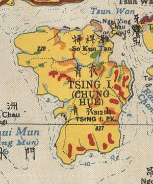
Location of Tsing Yi Peak in Hong Kong
| Tsing Yi Peak | |||||||||||||
|---|---|---|---|---|---|---|---|---|---|---|---|---|---|
| Chinese | 青衣山 | ||||||||||||
| |||||||||||||
| Sam Chi Heung | |||||||||||||
| Chinese | 三支香 | ||||||||||||
| Literal meaning | three joss sticks | ||||||||||||
| |||||||||||||
Tsing Yi Peak (Chinese: 青衣山; formerly spelled Tsing I Peak), also known as Sam Chi Heung (三支香; lit. 'three joss sticks'), is a hill with three peaks occupying the southern half of the Tsing Yi Island, Hong Kong. The hill is situated on the western half of Victoria Harbour. Its peaks are good locations to observe the harbour and the channels among harbour islands. While situated in the south, a short hill Liu To Shan occupies the northwest of the island.
The three peaks align along north and south, and their heights increase from north to south. The highest south peak is of 334 metres. There is a paved trail linking the three peaks.
Two tunnels run beneath the hill. Cheung Tsing Tunnel goes through the north peak while Nam Wan Tunnel through the three peaks in diagonal. There is no vehicle access to the peaks.
Most of the petroleum oil depots in Hong Kong are located on the south and west industrial area of the Tsing Yi Island. Tsing Yi Peak is a natural barrier protecting 200 thousand residents in the island north and east.
North peak
The foot of the north peak consists of the main burial ground for indigenous inhabitants of Tsing Yi Island. The burial ground occupies the north-east quadrant of the peak. A covered service reservoir with two football pitches are also situated near the residential area, Cheung Ching Estate and Cheung Hong Estate. The paved trail starting near the Cheung Ching Bus Terminus made a way to the peak via football pitch and burial ground. Alternative paved trail to peak starts from Mayfair Gardens near a bus stop at Ching Hong Road.
On the north peak erects a pavilion and a trigonometrical station. Most of the new town of Tsing Yi, Tsuen Wan and Kwai Chung, and the Rambler Channel is under its north and east while Ma Wan Channel, Tsing Ma Bridge, Liu To Shan and northeast Lantau Island under its west.
The paved trail continues south to meet the middle peak.
Middle peak
The middle peak is more cone-shaped than the other two. Great stones of various shapes gather at the highest points. An obstacle light was built by Civil Aviation Department near the stones. The middle peak is assigned as Hill No. 6 on the signboard of the light.
The middle peak is reachable by the paved trail or a less obvious path from Hong Kong Institute of Vocational Education (Tsing Yi). This path with paved ladders goes uphill along the valley between the north and middle peak. Agricultural fields are found in mid-level by a stream. The path become less obvious afterward. The burial ground of Chan's family helps to identify the way up to the above-mentioned paved trail.
South peak
The south peak is the highest among three peaks. The top of the peak is relatively flat. A trigonometrical station is highest point on the Tsing Yi Island. Like the middle peak, an obstacle light was established to help aeroplanes avoiding the peaks at night. The peak is assigned as Hill No. 5 on its signboard.
The southeast slope near the top was found the Hong Kong Croton and is now Site of Special Scientific Interest to protect the species.[1]
The south peak is a good situation to observe the south end of the Tsing Yi Island, Rambler Channel and Victoria Harbour. In a clear day, its south is surrounded by waters hugged by Kowloon Peninsula, Stonecutters Island, Hong Kong Island, Green Island, Kau Yi Chau, Peng Chau, Lantau Island, Tang Lung Chau and Ma Wan. Nearly a hundred ships are staying on the water. The Container Terminal 9 of Kwai Tsing Container Terminals is on its near shore and all others on another shore of Rambler Channel.
Apart from the paved trail leading from the middle peak, the south peak is also reachable from the direction of Ng Tsang Lau.
Footnotes
- ^ "Draft Tsing Yi OZP approved". Hong Kong Government. 2006-10-27. Retrieved 2007-03-28.
References
- Geographic Section, General Staff (1936), Hong Kong and The New Territories, War Office
See also
- v
- t
- e

- Sunset Peak
- The Hunch Backs
- Yin Ngam Teng
- Wo Tong Kong
- Grassy Hill
- Wong Leng
- Buffalo Hill
- West Buffalo Hill
- Kowloon Peak
- Shun Yeung Fung
- Tiu Shau Ngam
- Chau Ma Kong
- Middle Hill
- Lo Tin Teng
- Kai Kung Leng (Lam Tsuen)
- Castle Peak
- Lin Fa Shan (Tsuen Wan)
- Tate's Cairn
- Tai To Yan
- Wong Chuk Shan
- Victoria Peak
- Kwun Yam Shan (Yuen Long)
- Lai Pek Shan
- Tung Shan
- Chung Li Fung
- Shek Nga Shan
- Kau Nga Ling
- Pyramid Hill
- Tung Yeung Shan
- Needle Hill
- Mount Parker
- Kao Lao Fung
- Kuai Li Fung
- Pok To Yan
- Fu Yung Pit
- Hsien Ku Fung
- Sheung Tsz Fung
- Tsao Kau Fung
- Pak Tai To Yan
- Kau Keng Shan
- Mount Kellett
(excerpt)
- Lion Rock
- High West
- Sze Tsz Tau Shan
- Robin's Nest
- Ling Wui Shan
- Choi Wo Fung
- Hung Fa Chai
- Temple Hill
- Kwai Tau Leng
- Por Kai Shan
- Shek Uk Shan
- Muk Yue Shan
- Mount Gough
- Shek Lung Kung
- Sharp Peak
- Tai Hom Sham
- Wo Sheung Tung
- Lo Fu Tau
- Tin Fu Tsai Shan
- Keung Shan
- Beacon Hill
- Ngam Tau Shan
- Cheung Shan (Lantau Island)
- Cheung Yan Shan
- Cloudy Hill
- Mount Cameron
- Unicorn Ridge
- Mount Butler
- Kwun Yam Shan (Lantau)
- Violet Hill
- Jardine's Lookout
- Razor Hill
- Mount Nicholson
- Sham Hang Lek
- Middle Kau Nga Ling
- Siu Ma Shan
- Ngau Yee Shek Shan
- Tiu Tang Lung
- Luk Chau Shan
- Tai Cham Koi
- Luk Shan
(excerpt)
- Tai Sheung Tok
- Kai Kung Shan (Sai Kung)
- Kau To Shan
- Turret Hill
- Hebe Hill
- Wa Mei Shan
- The Twins South
- Lui Ta Shek
- Lau Fa Tung
- Yuen Tau Shan
- Nga Ying Shan
- Sugar Loaf Peak
- Kai Kung Shan (Lam Tsuen)
- Mount Hallowes
- Tai Mun Shan
- Golden Hill
- Fan Kei Tok
- Tin Mei Shan
- The Twins North
- Bird's Hill
- Cham Tin Shan
- Mount Stenhouse
- Mount Collinson
- Lower Hebe Hill
- High Junk Peak
- Cheung Lin Shan
- Shek Sze Shan
- Tsim Fung Shan
- Smuggler's Ridge
- Tsing Yi Peak
- Miu Tsai Tun
- D'Aguilar Peak
- Wo Liu Tun
- Sze Shan
- Tai Tun
- Sai Wan Shan (Sai Kung)
- Pottinger Peak
- Kwai Au Shan
- Eagle's Nest
- Black Hill
- Kwun Yam Tung
- Lo Yan Shan
- Tai Che Tung
- Tap Chai Shan
(excerpt)
- Tung Wan Shan
- Kung Um Shan
- Ma Tau Fung
- Tit Sze Kou
- Tai Leng Tung
- Tai Shan
- Brick Hill
- Shek O Peak
- Tai She Teng
- Tai Ngau Wu Teng
- Tin Ha Shan
- Fa Ping Teng
- Mount Davis
- Wan Cham Shan
- Ngau Wu Tun
- Kei Lak Chai
- Lung Fu Shan
- Ngo Sei Kai
- Sheung Yeung Shan
- Kwai Shan
- Ling Kok Shan
- Chiu Keng Wan Shan
- Tin Wan Shan
- Mau Wu Shan
- Bennet's Hill
- Tung Tau Teng
- Wang Tau Tun
- Nam Tong Teng
- Hung Heung Lo Fung
- Tai Yue Ngam Teng
- Piper's Hill
- Devil’s Peak
- Cheung Ngau Shan
- Kei Lun Shan
- San Sin Tseng Shan
- Tiu Chung Tai Shan
- Ping Tok Hang Shan
- Fa Shan
- Pai Tau Tun
- Cheung Ngau Shan
- Braemar Hill
- Boa Vista
- Pak Kok Shan
(excerpt)
- Sai Wan Shan (Chai Wan)
- Mount Johnston
- Crow's Nest
- Ping Shan
- Tai Yam Teng
- Shum Wan Shan
- Sha Tin Heights
- Cheung Shan (North District)
- Obelisk Hill
- Hammer Hill
- Cheung Shan (Sai Kung)
- Tai Ling (North District)
- Ho Hok Shan
- Fake Yuk Kwai Shan
- Siu Lam Hill
- Shouson Hill
- Ngai Tau
- Red Hill
- To Fung Shan
- Po Keng Teng
- Chung Hom Shan
- Cheung Pai Tun
- Kai Shan
- Kai Kung Leng (Kat O)
- Por Lo Shan
- Hung Tang Shan
- Crest Hill
- Duckling Hill
- Red Light Hill
(excerpt)
- Checkerboard Hill
- Pak Fu Shan
- Finger Hill
- Wong Shek
- Garden Hill
- Woh Chai Shan
- Diamond Hill
- Scenic Hill
- Pak Hok Shan
- Fu Shan
- Lo Shue Leng
- Yuen Chau Kok
- Cha Kwo Ling
- Tai Tseng Shan
- Duke's Hill
- Ko Po Shan
- Chu Wong Ling
- King's Park Hill
- Signal Hill
- Crocodile Hill
- Kadoorie Hill
- Sai Shan
- Observatory Hill
- Lung Shan (Ngau Tau Kok)
- Hok Ngam Teng
- Leighton Hill
- Quarry Hill
- Hung Hom Hill
- Lo Lung Hang Hill
- Shan Pui Leng
- Pak Fa Leng
- Mount Parish
- Mount Shadwell
- Caroline Hill
- Hong Kong Three Sharp Peaks
- Sai Kung Three Sharp Peaks
- Dragon's Back
- Eight Mountains of Kowloon
- Mini Pat Sin
- 4 Hills of Kowloon
- The Twins
- Pat Sin Leng
- Wong Leng
- Castle Peak Hinterland
- Four Guardian Beasts of Tai O
- Kai Kung Leng (Lam Tsuen)
22°20′14″N 114°06′01″E / 22.33725°N 114.100168°E / 22.33725; 114.100168


