Waverveen
Village in Utrecht, Netherlands

Flag
Coat of arms
52°13′52″N 4°50′6″E / 52.23111°N 4.83500°E / 52.23111; 4.83500
[1]
[2]
(2021)[1]
3646[1]
Waverveen is a village in the Dutch province of Utrecht. It is located in the municipality of De Ronde Venen, 3 km west of Vinkeveen.
Waverveen was a separate municipality until 1841, when it was merged with Vinkeveen to form the municipality of Vinkeveen en Waverveen. Until 1 October 1819, Waverveen was part of Holland.[3] The economy is mainly based on agriculture.
It was first mentioned in 1339 as "toit Waverveen", and means "moorland of the Waver (river)".[4] In 1672, French troops entered the village and demanded hay for their horses. They were not satisfied by the amount of hay, therefore, burnt to the village and killed several inhabitants. In 1840, it was home to 484 people.[5]
Gallery
-
 Church of Waverveen
 -
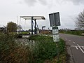
 Ferry across the canal
 -
 Bridge in Waverveen
 -
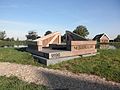 Nessersluis monument


References
- ^ a b c "Kerncijfers wijken en buurten 2021". Central Bureau of Statistics. Retrieved 28 March 2022.
- ^ "Postcodetool for 3646AA". Actueel Hoogtebestand Nederland (in Dutch). Het Waterschapshuis. Retrieved 28 March 2022.
- ^ Ad van der Meer and Onno Boonstra, Repertorium van Nederlandse gemeenten, KNAW, 2011.
- ^ "Waverveen - (geografische naam)". Etymologiebank (in Dutch). Retrieved 28 March 2022.
- ^ "Waverveen". Plaatsengids (in Dutch). Retrieved 28 March 2022.
Wikimedia Commons has media related to Waverveen.
- v
- t
- e
Populated places in the municipality of De Ronde Venen
- Abcoude
- Amstelhoek
- Baambrugge
- De Hoef
- Vinkeveen
- Waverveen
- Wilnis
 | This Utrecht location article is a stub. You can help Wikipedia by expanding it. |
- v
- t
- e


