Wesergebirge
The Weser Hills (Wesergebirge), also known in German as the Weserkette ("Weser Chain"),[1] form a low hill chain, up to 326.1 m above sea level (NN),[2] in the Weser Uplands in the German states of North Rhine-Westphalia and Lower Saxony.
The thickly wooded Weser ridge is one of the northern outliers of the German Central Uplands on the southern edge of the North German Plain and forms part of the TERRA.vita Nature Park in the west and Weser Uplands Schaumburg-Hameln Nature Park in the east.
The Weser Hills are widely known because of Schaumburg Castle which stands on the Nesselberg (c. 225 m above NN) in the Schaumburg district of the town of Rinteln, and is the emblem of Schaumburg Land.
Geography
The Weser Hills cross the counties of Minden-Lübbecke, Schaumburg and Hameln-Pyrmont in a roughly east–west direction, from the town of Porta Westfalica and the Westphalian Gap in the west past Rinteln to Hessisch Oldendorf in the east, where they transition seamlessly to the Süntel, a ridge of similar height running from northwest to southeast. They form part of the perimeter of the Weser Uplands and thus also the German Central Uplands which lie south of the North German Plain.
North of the Weser Hills there are only a few hills of the Calenberg Uplands, such as the nearby ridges of Harrl and Bückeberge. To the west, on the other side of the Porta Westfalica, the chain continues as the Wiehen Hills, geologically of similar formation, reaching Bramsche (northwest of Osnabrück).
South of the Weser Hills, and roughly parallel to them, flows the River Weser, from Hessisch-Oldendorf in the east, through Rinteln, towards Vlotho in the west, before turning northeast to the town of Porta Westfalica. These northern areas around the Upper Weser Valley, south of the hills are an old area of settlement, which was protected by Schaumburg Castle on the hill of Nesselberg. From the water gap at Porta Westfalica - the Westphalian Gap - the river swings north in order to reach the southern part of the North German Plain. North of the hills are the upper reaches of the Aue (also called the Bückeburger Aue) that run roughly east to west.
Hills
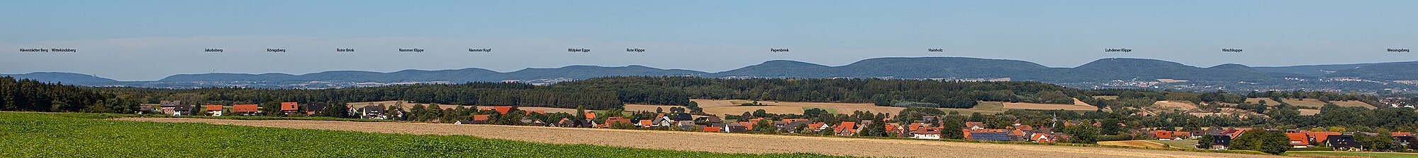
The Wesergebirge is a chain of about two dozen hills that are arranged one after another in a ridge and which reach a height of 326.1 m above NN at the Möncheberg in the east. In its centre section, west of the A 2 motorway, they reach a maximum height of 278 m at the Wülpker Egge and a height of 235.2 m at the westernmost hill of the Weser chain, the Jakobsberg, which is located east of Porta Westfalica and on which the Jakobsberg transmission tower stands.
The hills and elevations of the Wesergebirge, as seen from west to east, are given below together with their heights in metres above Normalnull (NN)[2] :
- Jakobsberg (235,2 m), with Jakobsberg Telecommunication Tower, Schlageter Monument and Porta Kanzel; north-northeast of the town of Porta Westfalica by the Porta Westfalica gorge
- Königsberg (c. 225 m); northeast of Porta Westfalica
- Roter Brink (c. 225 m), and Nammer Lager; south-southwest of Nammen
- Lohfelder Berg (215,2 m); northeast of Lohfeld
- Nammer Klippe (248,8 m); nature reserve; south of Nammen
- Nammer Kopf (266,3 m), and the Nammer Klippe, nature reserve; south-southeast of Nammen
- Wülpker Egge (c. 278 m), with a quarry; south of Wülpke
- Rote Klippe (c. 220 m), with a quarry; south of Kleinenbremen
- Papenbrink (303 m), with transmission facility and a quarry; north-northwest of Todenmann
- Lange Wand (320,1 m); in the Hainholz State Forest northeast of Todenmann
- Frankenburg-Berg (c. 235 m), and ruins of the Frankenburg; spur of the Langen Wand north of Rinteln-Todenmann
- Luhdener Klippe (c. 300 m), and the 19.8 m high Klippe Tower; north-northeast of Rinteln
- Hirschkuppe (250,1 m); northeast of Rinteln
- Messingsberg (270,1 m), with a quarry; north-northeast of Rinteln-Steinbergen
- Westendorfer Egge (c. 295 m), with a quarry; north-northeast of Rinteln-Westendorf
- Oberberg (325,2 m), and the Springsteinen; north of Rinteln-Schaumburg
- Heutzeberg (225,5 m); spur of the Oberberg north of Schaumburg
- Nesselberg (c. 225 m), and Schaumburg Castle on a spur of the Möncheberg east of Schaumburg
- Möncheberg (326,1 m), and the Paschenburg Guest House between Schaumburg and Hessisch Oldendorf-Rohdental
Panorama
Towns and villages
- Auetal (north)
- Bad Eilsen (north)
- Bückeburg (north)
- Heeßen (north)
- Hessisch Oldendorf (south)
- Minden (north)
- Porta Westfalica (south, west and north)
- Rinteln (south)
- Vlotho (southwest)
Literature
Bundesanstalt für Landeskunde und Raumforschung: Geographische Landesaufnahme 1:200000. Naturräumliche Gliederung Deutschlands. Die naturräumlichen Einheiten auf Blatt 85 Minden. Bad Godesberg 1959
External links
- Aerial photograph of the western Weser Hills at Google Maps [1]
- Aktionsgemeinschaft Weserbergland [2]
References
- ^ "Ein anderes Bild als die Bergländer der oberen Weser bieten die Weserkette, das Wiehengebirge und der Teutoburger Wald, see Christian Degn, et al. (ed.) Seydlitz, 1st Part, das deutsche Vaterland, wir und die Welt, 7th ed., Kiel, Hanover, 1954, p. 50
- v
- t
- e
- Anterior Bavarian Forest Einödriegel
- Black Forest Feldberg
- Bohemian Forest Großer Arber (Bavarian Forest Großer Arber)
- Deister Bröhn
- Ebbe Mountains Nordhelle
- Egge Mountains (Prussian) Velmerstot
- Eifel Hohe Acht (Volcanic Eifel Ernstberg)
- Elbe Sandstone Mountains Großer Zschirnstein
- Elm Eilumer Horn
- Elster Mountains Kapellenberg
- Fichtel Mountains Schneeberg (Steinwald Platte, Kohlwald Sieben-Linden-Berg)
- Franconian Forest Döbraberg
- Franconian Jura Dürrenberg
- Gladenbach Uplands Angelburg
- Goshawk Forest Hohes Gras
- Harz Brocken (Blocksberg)
- Hildesheim Forest Griesberg
- Hils Bloße Zelle
- Hoher Meißner Kasseler Kuppe
- Hunsrück Erbeskopf (Soonwald Ellerspring)
- Ith Lauensteiner Kopf
- Kaiserstuhl Totenkopf
- Kaufungen Forest Hirschberg
- Kellerwald Wüstegarten
- Knüll Eisenberg
- Kyffhäuser Kulpenberg
- Lenne Mountains Homert
- Lippe Uplands Köterberg
- North Palatine Uplands Donnersberg
- Odenwald Katzenbuckel
- Ore Mountains Fichtelberg
- Palatine Forest Kalmit
- Rhön Wasserkuppe
- Rothaar Mountains Langenberg
- Saalhausen Hills Himberg
- Siebengebirge Großer Ölberg
- Solling Große Blöße
- Spessart Geiersberg (Breitsol)
- Sudetes Lausche (Luž) (Lusatian Mountains Lausche (Luž) (Zittau Mountains Lausche (Luž)))
- Süntel Hohe Egge
- Swabian Jura Lemberg (Randen Hoher Randen)
- Taunus Großer Feldberg
- Teutoburg Forest (Osning) Barnacken
- Thuringian Forest Großer Beerberg
- Thuringian Slate Mountains Großer Farmdenkopf
- Upper Palatine Forest Kreuzfelsen
- Vogelsberg Taufstein
- Weser Hills Paschenburg Mountain
- Westerwald Fuchskaute
- Wiehen Hills Heidbrink