West Barsham
Village in the England
Human settlement in England
| West Barsham | |
|---|---|
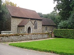 West Barsham church The Assumption of the Blessed Virgin Mary | |
| |
| District |
|
| Shire county |
|
| Region |
|
| Country | England |
| Sovereign state | United Kingdom |
| Post town | Fakenham |
| Postcode district | NR21 |
| Dialling code | 01328 |
| Police | Norfolk |
| Fire | Norfolk |
| Ambulance | East of England |
| UK Parliament |
|
| 52°51′59″N 0°49′47″E / 52.866251°N 0.829706°E / 52.866251; 0.829706 | |
West Barsham is a village and former civil parish, now in the parish of Barsham, in the North Norfolk district, in the county of Norfolk, England.[1] In 1931 the parish had a population of 89.[2] On 1 April 1935 the parish was abolished to form Barsham.[3]
The village is one of four settlements within the parish of Barsham. The other villages are North Barsham, East Barsham and Houghton St Giles.
West Barsham is 3.2 miles north of the town of Fakenham, 24.1 miles west of Cromer and 117 miles north of London. The nearest railway station is at Sheringham for the Bittern Line which runs between Sheringham, Cromer and Norwich. The nearest airport is Norwich International Airport.
References
- ^ OS Explorer Map 24 - Norfolk Coast Central. ISBN 0-319-21726-4.
- ^ "Population statistics West Barsham AP/CP through time". A Vision of Britain through Time. Retrieved 28 January 2023.
- ^ "Relationships and changes West Barsham AP/CP through time". A Vision of Britain through Time. Retrieved 28 January 2023.
External links
Wikimedia Commons has media related to West Barsham.
- Map sources for West Barsham
- v
- t
- e
- Alby with Thwaite
- Aldborough and Thurgarton
- Antingham
- Ashmanhaugh
- Aylmerton
- Baconsthorpe
- Bacton
- Barsham
- Barton Turf
- Beeston Regis
- Binham
- Blakeney
- Bodham
- Briningham
- Brinton
- Briston
- Brumstead
- Burgh and Tuttington
- Catfield
- Cley next the Sea
- Calthorpe
- Colby
- Corpusty and Saxthorpe
- Cromer
- Dilham
- Dunton
- East Beckham
- East Ruston
- Edgefield
- Erpingham
- Fakenham
- Felbrigg
- Felmingham
- Field Dalling
- Fulmodeston
- Gimingham
- Great Snoring
- Gresham
- Gunthorpe
- Hanworth
- Happisburgh
- Helhoughton
- Hempstead
- Hempton
- Hickling
- High Kelling
- Hindolveston
- Hindringham
- Holkham
- Holt
- Honing
- Horning
- Horsey
- Hoveton
- Ingham
- Ingworth
- Itteringham
- Kelling
- Kettlestone
- Knapton
- Langham
- Lessingham
- Letheringsett with Glandford
- Little Barningham
- Little Snoring
- Ludham
- Matlaske
- Melton Constable
- Morston
- Mundesley
- Neatishead
- Northrepps
- North Walsham
- Overstrand
- Paston
- Plumstead
- Potter Heigham
- Pudding Norton
- Raynham
- Roughton
- Runton
- Ryburgh
- Salthouse
- Scottow
- Sculthorpe
- Sea Palling
- Sheringham
- Sidestrand
- Skeyton
- Sloley
- Smallburgh
- Southrepps
- Stalham
- Stibbard
- Stiffkey
- Stody
- Suffield
- Sustead
- Sutton
- Swafield
- Swanton Abbott
- Swanton Novers
- Tatterford
- Tattersett
- Thornage
- Thorpe Market
- Thurning
- Thursford
- Trimingham
- Trunch
- Tunstead
- Upper Sheringham
- Walcott
- Walsingham
- Warham
- Wells-next-the-Sea
- West Beckham
- Westwick
- Weybourne
- Wickmere
- Wighton
- Witton
- Wiveton
- Wood Norton
- Worstead
- See also
- South Norfolk
- Great Yarmouth
- Broadland
- North Norfolk
- King's Lynn and West Norfolk
- Breckland
 | This Norfolk location article is a stub. You can help Wikipedia by expanding it. |
- v
- t
- e


