Wieda
Ortsteil of Walkenried in Lower Saxony, Germany

Coat of arms
Location of Wieda

51°37′57″N 10°35′09″E / 51.63250°N 10.58583°E / 51.63250; 10.58583
(2015-12-31)
37447
Wieda is a village and a former municipality in the district of Göttingen, in Lower Saxony, Germany. Since 1 November 2016, it is part of the municipality Walkenried.
Wieda is on River Wieda, a tributary of Zorge in the southern part of the Harz mountains.
Sights
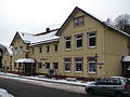
There are many well-preserved half-timbered houses in the center of Wieda, for example in the High Street close to the wooden Town Hall. The Old Clock Tower is on the top of a hill offering a scenic view of the municipality and its surroundings. Lutherkirche is the protestant town church which was built in 1770.[1]
-
 Protestant Church
 -
 Clock Tower
 -
 Half-timbered houses in the High Street
 -
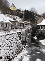
 River Wieda
 -
 Town Hall


References
Wikimedia Commons has media related to Wieda.
- ^ Ulrich Großmann: Hannover und Südniedersachsen, p. 192. Köln 1999
Authority control databases | |
|---|---|
| International |
|
| National |
|


