Al-Mirr
Al-Mirr المرّ / المحمودية Molendina desubter Mirabellum | |
|---|---|
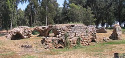 Reruntuhan tempat penggilingan | |
| Etimologi: "The passage".[1] | |
| 32°06′43″N 34°54′57″E / 32.11194°N 34.91583°E / 32.11194; 34.91583 | |
| Grid Palestina | 142/168 |
| Entitas geopolitik | Mandat Palestina |
| Subdistrik | Jaffa |
| Tanggal pengosongan | Februari atau Maret 1948[4] |
| Luas | |
| • Total | 51 dunams (5,1 ha or 13 acre) |
| Populasi (1945) | |
| • Total | 170[2][3] |
| Sebab pengosongan | Kekhawatiran akan ditangkap dalam pertikaian |
Al-Mirr, juga disebut Mahmudiyeh ("harta benda Mahmud"),[1] adalah sebuah desa Rab Palestina di Subdistrik Jaffa. Desa tersebut dikosongkan dalam Perang Saudara Mandat Palestina 1947–1948 pada 1 Februari 1948.
Referensi
Daftar pustaka
- Barron, J.B., ed. (1923). Palestine: Report and General Abstracts of the Census of 1922. Government of Palestine.
- Clermont-Ganneau, C.S. (1895). Études d'archéologie orientale (dalam bahasa French). Paris: E. Bouillon. Pemeliharaan CS1: Bahasa yang tidak diketahui (link) (pp. 192−196: "Les Trois−Ponts, Jorgilia")
- Conder, C.R.; Kitchener, H.H. (1882). The Survey of Western Palestine: Memoirs of the Topography, Orography, Hydrography, and Archaeology. 2. London: Committee of the Palestine Exploration Fund.
- Government of Palestine, Department of Statistics (1945). Village Statistics, April, 1945.
- Hadawi, S. (1970). Village Statistics of 1945: A Classification of Land and Area ownership in Palestine. Palestine Liberation Organization Research Center. Diarsipkan dari versi asli tanggal 2018-12-08. Diakses tanggal 2009-08-18. Parameter
|url-status=yang tidak diketahui akan diabaikan (bantuan) - Hartmann, M. (1883). "Die Ortschaftenliste des Liwa Jerusalem in dem türkischen Staatskalender für Syrien auf das Jahr 1288 der Flucht (1871)". Zeitschrift des Deutschen Palästina-Vereins. 6: 102–149.
- Khalidi, W. (1992). All That Remains: The Palestinian Villages Occupied and Depopulated by Israel in 1948. Washington D.C.: Institute for Palestine Studies. ISBN 0-88728-224-5. ISBN 0-88728-224-5.
- Morris, B. (2004). The Birth of the Palestinian Refugee Problem Revisited. Cambridge University Press. ISBN 0-521-00967-7.
- Mills, E., ed. (1932). Census of Palestine 1931. Population of Villages, Towns and Administrative Areas. Jerusalem: Government of Palestine.
- Palmer, E.H. (1881). The Survey of Western Palestine: Arabic and English Name Lists Collected During the Survey by Lieutenants Conder and Kitchener, R. E. Transliterated and Explained by E.H. Palmer. Committee of the Palestine Exploration Fund.
- Petersen, Andrew (2001). A Gazetteer of Buildings in Muslim Palestine (British Academy Monographs in Archaeology). 1. Oxford University Press. ISBN 978-0-19-727011-0.
- Pringle, Denys (1997). Secular buildings in the Crusader Kingdom of Jerusalem: an archaeological Gazetter. Cambridge University Press. ISBN 0521 46010 7.
- Röhricht, R. (1893). (RRH) Regesta regni Hierosolymitani (MXCVII-MCCXCI) (dalam bahasa Latin). Berlin: Libraria Academica Wageriana.
- Shkolnik, Y. (1994); Urban River, EGMI, 34, March–April, pp. 16–34, 71. Cited in Petersen, 2001.
- Socin, A. (1879). "Alphabetisches Verzeichniss von Ortschaften des Paschalik Jerusalem". Zeitschrift des Deutschen Palästina-Vereins. 2: 135–163.
Pranala luar
- Welcome To al-Mirr
- al-Mirr (Mahmudiya), Zochrot
- Survey of Western Palestine, Map 13: IAA, Wikimedia commons
- Al-Mirr, from the Khalil Sakakini Cultural Center


