Al-Qabu
al-Qabu القبو Qabu, Kabu | |
|---|---|
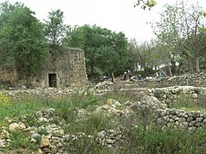 Masjid Shaykh Ahmad al-Umari | |
| Etimologi: "the vault, or cellar"[1] | |
| 31°43′40″N 35°07′10″E / 31.72778°N 35.11944°E / 31.72778; 35.11944 | |
| Grid Palestina | 161/126 |
| Entitas geopolitik | Mandat Palestina |
| Subdistrik | Yerusalem |
| Tanggal pengosongan | 22–23 Oktober 1948[4] |
| Luas | |
| • Total | 3,806 dunams (3,806 km2 or 1,470 sq mi) |
| Populasi (1945) | |
| • Total | 260[2][3] |
| Sebab pengosongan | Serangan militer oleh pasukan Yishuv |
| Wilayah saat ini | Mevo Beitar |
Al-Qabu (bahasa Arab: القبو),[1] adalah sebuah desa Arab Palestina di Subdistrik Yerusalem. Namanya adalah sebuah variasi Arab dari nama Romawi asli di situs tersebut, dan reruntuhan gereja disana telah ada sejak era kekuasaan Bizantium atau Salibis di Palestina.
Al-Qabu dikosongkan pada 22–23 Oktober 1948, usai Perang Arab-Israel 1948.[5][6] Usai pendirian Israel, rumah-rumah di desa tersebut diledakkan oleh pasukan Israel pada Mei 1949 dan 1950. Moshav Mevo Beitar didirikan di atas lahan desa tersebut.
Referensi
- ^ a b Palmer, 1881, p. 297
- ^ a b Government of Palestine, Department of Statistics. Village Statistics, April, 1945. Quoted in Hadawi, 1970, p. 58 Diarsipkan 2018-11-03 di Wayback Machine.
- ^ Government of Palestine, Department of Statistics, 1945, p. 25
- ^ Morris, 2004, p. xx, village #348. Also gives cause of depopulation.
- ^ Khalidi, 1992, pp. 307-308.
- ^ Morris, 2004, p. 520, note 111
Daftar pustaka
- Barron, J.B., ed. (1923). Palestine: Report and General Abstracts of the Census of 1922. Government of Palestine.
- Billig, Ya’akov (2005-04-19). "En Qobi" (117). Hadashot Arkheologiyot – Excavations and Surveys in Israel.
- Conder, C.R.; Kitchener, H.H. (1883). The Survey of Western Palestine: Memoirs of the Topography, Orography, Hydrography, and Archaeology. 3. London: Committee of the Palestine Exploration Fund.
- Government of Palestine, Department of Statistics (1945). Village Statistics, April, 1945.
- Guérin, V. (1869). Description Géographique Historique et Archéologique de la Palestine (dalam bahasa French). 1: Judee, pt. 2. Paris: L'Imprimerie Nationale. Pemeliharaan CS1: Bahasa yang tidak diketahui (link)
- Hadawi, S. (1970). Village Statistics of 1945: A Classification of Land and Area ownership in Palestine. Palestine Liberation Organization Research Center. Diarsipkan dari versi asli tanggal 2018-12-08. Diakses tanggal 2017-06-16. Parameter
|url-status=yang tidak diketahui akan diabaikan (bantuan) - Hartmann, M. (1883). "Die Ortschaftenliste des Liwa Jerusalem in dem türkischen Staatskalender für Syrien auf das Jahr 1288 der Flucht (1871)". Zeitschrift des Deutschen Palästina-Vereins. 6: 102–149.
- Jordan. Dāʾirat al-Āthār al-ʻĀmmah (1991). Annual of the Department of Antiquities, Volume 35. Dept. of Antiquities, Hashemite Kingdom of Jordan.
- Khalidi, W. (1992). All That Remains: The Palestinian Villages Occupied and Depopulated by Israel in 1948. Washington D.C.: Institute for Palestine Studies. ISBN 0-88728-224-5.
- Mills, E., ed. (1932). Census of Palestine 1931. Population of Villages, Towns and Administrative Areas. Jerusalem: Government of Palestine.
- Morris, B. (2004). The Birth of the Palestinian Refugee Problem Revisited. Cambridge University Press. ISBN 978-0-521-00967-6.
- Palmer, E.H. (1881). The Survey of Western Palestine: Arabic and English Name Lists Collected During the Survey by Lieutenants Conder and Kitchener, R. E. Transliterated and Explained by E.H. Palmer. Committee of the Palestine Exploration Fund.
- Petersen, Andrew (2001). A Gazetteer of Buildings in Muslim Palestine (British Academy Monographs in Archaeology). 1. Oxford University Press. ISBN 978-0-19-727011-0.
- Pringle, Denys (1998). The Churches of the Crusader Kingdom of Jerusalem: L-Z (excluding Tyre). II. Cambridge University Press. ISBN 0 521 39037 0.
- Robinson, E.; Smith, E. (1841). Biblical Researches in Palestine, Mount Sinai and Arabia Petraea: A Journal of Travels in the year 1838. 2. Boston: Crocker & Brewster.
- Robinson, E.; Smith, E. (1841). Biblical Researches in Palestine, Mount Sinai and Arabia Petraea: A Journal of Travels in the year 1838. 3. Boston: Crocker & Brewster.
- Socin, A. (1879). "Alphabetisches Verzeichniss von Ortschaften des Paschalik Jerusalem". Zeitschrift des Deutschen Palästina-Vereins. 2: 135–163.
- Tsafrir, Y.; Leah Di Segni; Judith Green (1994). (TIR): Tabula Imperii Romani: Judaea, Palaestina. Jerusalem: Israel Academy of Sciences and Humanities. ISBN 965-208-107-8. Cited in Petersen, 2001
- Weiss, Danny (2006-09-20). "En Qobi" (118). Hadashot Arkheologiyot – Excavations and Surveys in Israel.
- Zissu, Boaz; Weiss, Danny (2008-02-11). "En Qobi" (120). Hadashot Arkheologiyot – Excavations and Surveys in Israel.


