Ein Hod
Ein Hod עֵין הוֹד | |
|---|---|
 | |
  Ein Hod  Ein Hod | |
| Koordinat: Lua error in package.lua at line 80: module 'Module:ISO 3166/data/IL' not found. | |
| Negara | |
| Distrik | Haifa |
| Dewan | Hof HaCarmel |
| Populasi (2018)[1] | 632 |
| Situs web | ein-hod.org |
Ayn Hawd عين حوض | |
|---|---|
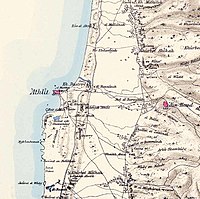 Peta Ayn Hawd dan wilayah sekitarnya, 1870an. The Survey of Western Palestine. London:Committee of the Palestine Exploration Fund | |
 Ayn Hawd | |
| Koordinat: 32°42′05″N 34°58′48″E / 32.70139°N 34.98000°E / 32.70139; 34.98000 | |
| Grid Palestina | 148/234 |
| Entitas geopolitik | Mandat Palestina |
| Subdistrik | Haifa |
| Tanggal pengosongan | 15 Juli 1948[4] |
| Luas | |
| • Total | 12,605 dunams (12,605 km2 or 4,867 sq mi) |
| Populasi (1945) | |
| • Total | 650[2][3] |
| Sebab pengosongan | Serangan militer oleh pasukan Yishuv |
| Wilayah saat ini | Ein Hod[5][6] Nir Etzion[6] |
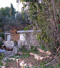
Ein Hod (Ibrani: עֵין הוֹד) adalah sebuah desa di Distrik Haifa di utara Israel. Berada di kaki Gunung Karmel dan tenggara Haifa, desa tersebut berada di bawah yurisdiksi Dewan Regional Hof HaCarmel dan memiliki status pemukiman komunitas. Pada 2018, desa tersebut memiliki populasi 632.[1]
Referensi
- ^ a b "Population in the Localities 2018" (XLS). Israel Central Bureau of Statistics. 25 August 2019. Diakses tanggal 26 August 2019.
- ^ a b Government of Palestine, Department of Statistics. Village Statistics, April, 1945. Quoted in Hadawi, 1970, p. 47
- ^ Government of Palestine, Department of Statistics, 1945, p. 13
- ^ Morris, 2004, p. XVIII, village #170. Also gives causes of depopulation.
- ^ Morris, 2004, p. XXII, Settlement #123, established 1949.
- ^ a b Khalidi, 1992, p. 151
Daftar pustaka
- Barron, J.B., ed. (1923). Palestine: Report and General Abstracts of the Census of 1922. Government of Palestine.
- Benveniśtî, M. (2000). Sacred landscape: the buried history of the Holy Land since 1948 (edisi ke-Illustrated). University of California Press. ISBN 0-520-21154-5.
- Conder, C.R.; Kitchener, H.H. (1881). The Survey of Western Palestine: Memoirs of the Topography, Orography, Hydrography, and Archaeology. 1. London: Committee of the Palestine Exploration Fund.
- Government of Palestine, Department of Statistics (1945). Village Statistics, April, 1945.
- Guérin, V. (1875). Description Géographique Historique et Archéologique de la Palestine (dalam bahasa French). 2: Samarie, pt. 2. Paris: L'Imprimerie Nationale. Pemeliharaan CS1: Bahasa yang tidak diketahui (link)
- Hadawi, S. (1970). Village Statistics of 1945: A Classification of Land and Area ownership in Palestine. Palestine Liberation Organization Research Center.
- Hütteroth, Wolf-Dieter; Abdulfattah, Kamal (1977). Historical Geography of Palestine, Transjordan and Southern Syria in the Late 16th Century. Erlanger Geographische Arbeiten, Sonderband 5. Erlangen, Germany: Vorstand der Fränkischen Geographischen Gesellschaft. ISBN 3-920405-41-2.
- Khalidi, W. (1992). All That Remains: The Palestinian Villages Occupied and Depopulated by Israel in 1948. Washington D.C.: Institute for Palestine Studies. ISBN 0-88728-224-5.
- Mills, E., ed. (1932). Census of Palestine 1931. Population of Villages, Towns and Administrative Areas. Jerusalem: Government of Palestine.
- Morris, B. (2004). The Birth of the Palestinian Refugee Problem Revisited. Cambridge University Press. ISBN 978-0-521-00967-6.
- Mülinen, Egbert Friedrich von 1908, Beiträge zur Kenntnis des Karmels "Separateabdruck aus der Zeitschrift des Deutschen Palëstina-Vereins Band XXX (1907) Seite 117–207 und Band XXXI (1908) Seite 1–258."
- Palmer, E.H. (1881). The Survey of Western Palestine: Arabic and English Name Lists Collected During the Survey by Lieutenants Conder and Kitchener, R. E. Transliterated and Explained by E.H. Palmer. Committee of the Palestine Exploration Fund.
- Schumacher, G. (1888). "Population list of the Liwa of Akka". Quarterly statement – Palestine Exploration Fund. 20: 169–191.
- Slyomovics, Susan (1998). The object of memory: Arab and Jew narrate the Palestinian village (edisi ke-Illustrated). University of Pennsylvania Press. ISBN 978-0-8122-1525-0. (winner of the 1999 Albert Hourani Book Award) (p. 100)
- Velde, van de, C.W.M. (1854). Narrative of a journey through Syria and Palestine in 1851 and 1852. 1. William Blackwood and son.
Pranala luar
Wikimedia Commons memiliki media mengenai Ein Hod.
- Ein Hod – The Artists' Site
- Battle of Ein Hod
- The Janco Dada Museum
- Ein Hud – International architecture competition F.A.S.T.
- In and around Ein Hod 30 April 2006, Ynetnews
- ISRAEL: An IDP village sees light at the end of the tunnel IRIN, 5 August 2007
- "Hurdy-Gurdy Time", Adena Kerstein (30 September 2005), Jerusalem Post
- Ein Hod: A Unique Village in Israel, Emunah magazine
- What would Janco say? Haaretz, 12 April 2007
- 'Ayn Hawd in the Palestine Remembered database
- 'Ayn Hawd, Zochrot
- Survey of Western Palestine, Map 5: IAA, Wikimedia commons


