Kafr Bir'im
Kafr Bir'im كفر برعم Kefr Berem | |
|---|---|
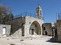 Gereja Kafr Bir'im | |
| Etimologi: Desa Bir'im[1] | |
| 33°02′37″N 35°24′51″E / 33.04361°N 35.41417°E / 33.04361; 35.41417 | |
| Palestina | 189/272 |
| Negara | Mandat Britania atas Palestina |
| Subdistrik | Safad |
| Penduduk diusir pasukan Yishuv | Awal November 1948[3] |
| Luas | |
| • Total | 12,250 dunams (12,25 km2 or 4,73 sq mi) |
| Populasi (1945) | |
| • Total | 710[2] |
| Satuan wilayah saat ini | Bar'am[4][5] Dovev[5] |
Kafr Bir'im, juga disebut Kefr Berem (bahasa Arab: كفر برعم, bahasa Ibrani: כְּפַר בִּרְעָם), adalah sebuah desa Kristen Palestina yang pernah berdiri di wilayah Israel utara, sekitar 4 km dari perbatasan dengan Lebanon. Pada tahun 1945, terdapat 710 orang yang tinggal di desa ini dan sebagian besar adalah umat Kristen Palestina. Pada tahun 1948, penduduk desa ini diusir oleh tentara Israel. Pada tahun 1992, satu-satunya struktur yang masih tersisa adalah gereja desa dengan menara loncengnya.
Sejarah
Desa Kafr Bir'im sudah ada sejak zaman kuno. Menurut tradisi Yahudi, Pinchas ben Yair (abad ke-2 M) dikebumikan di Kfar Bir'im.[6] Tidak diketahui secara pasti kapan orang Yahudi meninggalkan desa ini, tetapi kemungkinan peristiwa tersebut terjadi antara abad ke-7 hingga ke-13.[7][8] Setelah sempat dihuni oleh umat Muslim,[9] pada abad ke-19 desa ini dihuni oleh orang Kristen Palestina dari aliran Maronit dan Melkit.[10]
Desa ini mengalami kerusakan besar akibat gempa bumi Galilea 1837.[11] Menurut daftar penduduk dari tahun 1887, desa Kefr Bir’im dihuni oleh sekitar 1.285 orang Kristen.[12] Pada tahun 1945, jumlah penduduknya tercatat sebesar 710 jiwa, dengan 10 di antaranya adalah orang Muslim dan 700 orang Kristen.[2]
Tentara Israel merebut desa ini pada 31 Oktober 1948 selama Operasi Hiram. Penduduk desa ini kemudian dipaksa pergi.[13] Pada tahun 1949, karena musuh sering menyusup masuk dari perbatasan dengan Lebanon, para penduduk desa dilarang kembali ke kampung halaman mereka.[14] Pada 16 Juni 1949, Kibbutz Bar'am didirikan oleh serdadu Palmach yang sudah didemobilisasi tidak jauh dari lokasi desa ini.
Pada tahun 1953, warga Kafr Bir'im mengajukan perkara ke Mahkamah Agung Israel agar mereka dapat pulang ke desa mereka. Mahkamah Agung Israel memutuskan bahwa pemerintah harus memberikan jawaban resmi kenapa warga desa tidak diperbolehkan pulang. Pada 16 September 1953, desa ini dihancurkan dan 1.170 hektare lahan disita negara.[15]
Catatan kaki
- ^ Palmer, 1881, hlm. 76
- ^ a b Department of Statistics, 1945, p. 10
- ^ Morris, 2004, p. xvi, village #38. Also gives cause of depopulation.
- ^ Morris, 2004, hlm. xxii, settlement #160
- ^ a b Khalidi, 1992, hlm. 461
- ^ Burial Places of the Fathers, diterbitkan oleh Yehuda Levi Nahum in book: Ṣohar la-ḥasifat ginzei teiman (Heb. צהר לחשיפת גנזי תימן), Tel-Aviv 1986, hlm. 252
- ^ Judaism in late antiquity, Jacob Neusner, Bertold Spuler, Hady R Idris, BRILL, 2001, hlm. 155
- ^ Art and Judaism in the Greco-Roman world: toward a new Jewish archaeology, Steven Fine, Cambridge University Press, 2005, hlm. 13-14
- ^ Hütteroth and Abdulfattah, 1977, hlm. 175
- ^ Robinson and Smith, 1856, hlm. 68-71
- ^ "The earthquake of 1 January 1837 in Southern Lebanon and Northern Palestine" by N. N. Ambraseys, in Annali di Geofisica, August 1997, hlm.933.
- ^ Schumacher, 1888, p. 190
- ^ Benny Morris (2004): The Birth of the Palestinian Refugee Problem Revisited, ISBN 0-521-00967-7, hlm. XXII, settlement #160.
- ^ Palestine's border wars, 1949-1956: Arab infiltration, Israeli retaliation, and the countdown to the Suez War, Benny Morris, 2nd Edition, Oxford University Press, 1997, hlm. 124
- ^ Sabri Jiryis: "Kouetz 307 (27. Aug. 1953): 1419"
Daftar pustaka
- Barron, J.B., ed. (1923). Palestine: Report and General Abstracts of the Census of 1922. Government of Palestine.
- Benvenisti, M. (2000). Sacred Landscape: The Buried History of the Holy Land Since 1948
 . Maxine Kaufman-Lacusta (translator). University of California Press. ISBN 0-520-92882-2.
 - Conder, C.R.; Kitchener, H.H. (1881). The Survey of Western Palestine: Memoirs of the Topography, Orography, Hydrography, and Archaeology. 1. London: Committee of the Palestine Exploration Fund.
- Chacour, E.: "Blood Brothers. A Palestinian Struggles for Reconciliation in the Middle East" ISBN 0-8007-9321-8 with Hazard, David, and Baker III, James A., Secretary (Foreword by) 2nd Expanded ed. 2003.
- Dalrymple, W. (1997): From the Holy Mountain, Harper Collins, ISBN 0-00-255509-3 p. 268-9, 271, 275-6, 363, 365-72. Dalrymple interviewed Sarah Daou from Kafr Bir'im and goes there to find her relatives.
- Department of Statistics (1945). Village Statistics, April, 1945. Government of Palestine.
- Fine, S. (2005). Art and Judaism in the Greco-Roman world: toward a new Jewish archaeology. Cambridge University Press. ISBN 0521844916.
- Gilmour, David (1982). Dispossessed. The Ordeal of the Palestinians. Sphere books. ISBN 9780722138427. pp. 102–103
- Guérin, V. (1880). Description Géographique Historique et Archéologique de la Palestine (dalam bahasa Prancis). 3: Galilee, pt. 2. Paris: L'Imprimerie Nationale.
- Hadawi, S. (1970). Village Statistics of 1945: A Classification of Land and Area ownership in Palestine. Palestine Liberation Organization Research Center.
- Hütteroth, Wolf-Dieter; Abdulfattah, Kamal (1977). Historical Geography of Palestine, Transjordan and Southern Syria in the Late 16th Century. Erlanger Geographische Arbeiten, Sonderband 5. Erlangen, Germany: Vorstand der Fränkischen Geographischen Gesellschaft. ISBN 3-920405-41-2.
- Jiryis, S.: The Arabs in Israel 1st American edition 1976 ISBN 0-85345-377-2 (updated from the 1966 ed.) With a foreword by Noam Chomsky. (First English edition; Beirut, Institute for Palestine Studies, 1968). Chapter 4.
- Khalidi, W. (1992). All That Remains: The Palestinian Villages Occupied and Depopulated by Israel in 1948. Washington D.C.: Institute for Palestine Studies. ISBN 0-88728-224-5.
- Mills, E., ed. (1932). Census of Palestine 1931. Population of Villages, Towns and Administrative Areas. Jerusalem: Government of Palestine.
- Morris, B. and Black, I. (1991): Israel's Secret Wars: A History of Israel's Intelligence Services (Grove Press, 1991) ISBN 0-8021-1159-9
- Morris, B. (1994). 1948 and after; Israel and the Palestinians. Oxford University Press.
- Morris, B. (1997). Israel's Border Wars, 1949 - 1956. Arab Infiltration, Israeli Retaliation, and the Countdown to the Suez War. Oxford University Press. ISBN 0-19-829262-7.
- Morris, B. (2004). The Birth of the Palestinian Refugee Problem Revisited. Cambridge University Press. ISBN 978-0-521-00967-6.
- Palmer, E.H. (1881). The Survey of Western Palestine: Arabic and English Name Lists Collected During the Survey by Lieutenants Conder and Kitchener, R. E. Transliterated and Explained by E.H. Palmer. Committee of the Palestine Exploration Fund.
- Rhode, H. (1979). Administration and Population of the Sancak of Safed in the Sixteenth Century (Tesis PhD). Columbia University. https://www.academia.edu/2026845. "Salinan arsip". Diarsipkan dari versi asli tanggal 2020-03-01. Diakses tanggal 2022-03-09.
- Robinson, E.; Smith, E. (1841). Biblical Researches in Palestine, Mount Sinai and Arabia Petraea: A Journal of Travels in the year 1838. 3. Boston: Crocker & Brewster.
- Robinson, E.; Smith, E. (1856). Later Biblical Researches in Palestine and adjacent regions: A Journal of Travels in the year 1852. London: John Murray.
- Schumacher, G. (1888). "Population list of the Liwa of Akka". Quarterly Statement - Palestine Exploration Fund. 20: 169–191.
- Yazbak, M. (1998). Haifa in the Late Ottoman Period, A Muslim Town in Transition, 1864–1914. Brill Academic Pub. ISBN 90-04-11051-8.


