Blue Cow Mountain

36°22′S 148°24′E / 36.367°S 148.400°E / -36.367; 148.400Vertical355 m (1,165 ft)Top elevation1,890 m (6,200 ft)Base elevation1,605 m (5,266 ft)Skiable area1,245 ha (3,080 acres)Longest run3 km (1.9 mi)Total lengthover 100 km (62 mi)Lift system48 liftsLift capacitypassengers/hrTerrain parksKosciuszko National ParkWebsiteperisher.com.au
Blue Cow Mountain
The Blue Cow
Mount Blue Cow
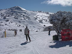
Looking towards the summit from outside Blue Cow Terminal.
Highest point
Elevation1,901 m (6,237 ft)[1]
AHD
Parent peakMount Kosciuszko
ListingMountains of New South Wales
Coordinates36°22′S 148°23′E / 36.367°S 148.383°E / -36.367; 148.383[2]
Geography
Blue Cow Mountain is located in New South Wales
Blue Cow Mountain
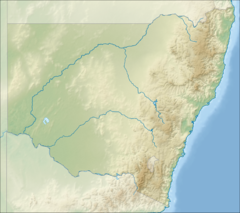
Blue Cow Mountain
Location of Blue Cow Mountain in New South Wales
CountryAustralia
StateNew South Wales
Parent rangeSnowy Mountains
Topo mapGeehi Dam

Blue Cow is a ski resort that is part of Perisher located in the Snowy Mountains of New South Wales, Australia, within the Snowy Monaro Regional Council. The resort is situated within the Kosciuszko National Park and is administered by the NSW National Parks & Wildlife Service. During winter months, the only access to the village is via the Skitube underground railway. In summer, access is via off-road only. Blue Cow is one of the four resort bases within Perisher, Australia's largest ski resort.

Also known as the Blue Cow Mountain, Mount Blue Cow or The Blue Cow,[2] the mountain lies within the Main Range of Snowy Mountains, part of the Great Dividing Range. Blue Cow Mountain has an elevation of 1,901 metres (6,237 ft) above sea level.[1]

Skiing

Looking back from summit of Ridge Quad Chair towards Blue Cow Terminal.

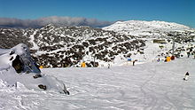
The last establishment of a major skifield in New South Wales came with the development of Mount Blue Cow in the 1980s. In 1987 the Skitube Alpine Railway opened to deliver skiers from Bullocks Flat, on the Alpine Way, to Perisher Valley and to Blue Cow, which also opened in 1987.[3] The operators of Blue Cow purchased Guthega in 1991, and the new combined resort later merged with Perisher-Smiggins to become the largest ski resort in the Southern Hemisphere.[3] In 2022 Perisher had 48 lifts covering 1,245 hectares (3,080 acres) and four village base areas: Perisher Valley, Blue Cow, Smiggin Holes and Guthega.[4]

Blue Cow has eight ski lifts:

  • Ridge Quad Chair
  • Summit Quad Chair
  • Early Starter Double Chair
  • Terminal Quad Chair
  • Brumby T-Bar
  • Pony Ride Carpet
  • Snowsports School Rope Tow (Snowsports School only)
  • Pleasant Valley Quad Chair

See also

  • flagNew South Wales portal
  • iconMountains portal

References

  1. ^ a b "Map of Blue Cow Mountain Terminal, NSW". Bonzle Digital Atlas of Australia. Retrieved 10 May 2015.
  2. ^ a b "Blue Cow Mountain". Geographical Names Register (GNR) of NSW. Geographical Names Board of New South Wales. Retrieved 10 May 2015. Edit this at Wikidata
  3. ^ a b "The History of Perisher". perisher.com.au. Retrieved 1 May 2023.
  4. ^ "Resort Stats". perisher.com.au. Retrieved 27 August 2022.
  • Perisher Home Page
  • "Topographic map of Blue Cow Mountain". opentopomap.org. Retrieved 1 May 2023.
  • v
  • t
  • e
Rural places
Main Article: Local government areas of New South Wales
  • v
  • t
  • e
Australian skifields
NSW
Victoria
Tasmania
ACT
Former skifields
  • v
  • t
  • e
Coastal mountain ranges
(not part of the
Great Dividing Range)
Mid North Coast
  • Middle Brother (554 m or 1,818 ft)
  • South Brother (487 m or 1,598 ft)
  • North Brother (476 m or 1,562 ft)
Allyn, Barrington
& Mount Royal
  • Brumlow Tops (1,586 m or 5,203 ft)
  • Polblue (1,575 m or 5,167 ft)
  • Barrington (1,555 m or 5,102 ft)
  • Careys Peak (1,544 m or 5,066 ft)
  • Eremeren Point (1,537 m or 5,043 ft)
  • Royal (1,185 m or 3,888 ft)
  • Allyn (1,125 m or 3,691 ft)
  • Cabrebald (1,000 m or 3,281 ft)
  • Ben Bullen
  • Gunama
  • Lumeah
Gibraltar and Sugarloaf
Blue Mountains
  • Coricudgy (1,255 m or 4,117 ft)
  • unnamed peak (1,189 m or 3,901 ft)
  • Pomany (1,109 m or 3,638 ft)
  • Piddington (1,094 m or 3,589 ft)
  • Boyce (1,093 m or 3,586 ft)
  • York (1,061 m or 3,481 ft)
  • Victoria (1,059 m or 3,474 ft)
  • Banks (1,049 m or 3,442 ft)
  • Tomah (1,016 m or 3,333 ft)
  • Wilson (1,008 m or 3,307 ft)
  • Kings Tableland (1,000 m or 3,281 ft)
  • Narrow Neck Plateau (1,000 m or 3,281 ft)
  • Bell (998 m or 3,274 ft)
  • Castle Cliff (986 m or 3,235 ft)
  • Solitary (950 m or 3,117 ft)
  • Hay (944 m or 3,097 ft)
  • Podgers (890 m or 2,920 ft)
  • Irvine (850 m or 2,789 ft)
  • Debert (840 m or 2,756 ft)
  • Camp Cave (800 m or 2,625 ft)
  • Warrigal (760 m or 2,493 ft)
  • Notts (750 m or 2,461 ft)
  • Harris (736 m or 2,415 ft)
  • Centre (620 m or 2,034 ft)
  • Hall (617 m or 2,024 ft)
  • Gibson (608 m or 1,995 ft)
  • Scorpion (558 m or 1,831 ft)
  • Linda Rock (599 m or 1,965 ft)
  • Cookem (569 m or 1,867 ft)
  • Gospers
  • Bedford
  • Cameron
  • Coriaday
  • Erskine
  • Mistake
  • Monundilla
  • Whaite
  • Wirraba
  • Pearces
  • Wedding Cake
Illawarra
  • Bells (803 m or 2,635 ft)
  • Knights Hill (709 m or 2,326 ft)
  • Noorinan (663 m or 2,175 ft)
  • Saddleback (600 m or 1,969 ft)
  • Wanyambilli Hill (564 m or 1,850 ft)
  • Kembla (534 m or 1,752 ft)
  • Burelli (531 m or 1,742 ft)
  • Kembla West (512 m or 1,680 ft)
  • Brisbane (469 m or 1,539 ft)
  • Keira (464 m or 1,522 ft)
  • Warra (464 m or 1,522 ft)
  • Brokers Nose (440 m or 1,444 ft)
  • Nebo (252 m or 827 ft)
The Budawangs
  • Budawang (1,129 m or 3,704 ft)
  • Currockbilly (1,087 m or 3,566 ft)
  • Wog Wog (893 m or 2,930 ft)
  • Cole (876 m or 2,874 ft)
  • Sturgiss (858 m or 2,815 ft)
  • Fosters (857 m or 2,812 ft)
  • Barneys Hill (855 m or 2,805 ft)
  • The Castle (831 m or 2,726 ft)
  • Shrouded Gods (809 m or 2,654 ft)
  • Donjon (786 m or 2,579 ft)
  • Clyde (781 m or 2,562 ft)
  • Quiltys (775 m or 2,543 ft)
  • Wirritin (674 m or 2,211 ft)
  • Pigeon House / Didthul (720 m or 2,362 ft)
  • Bushwalker (640 m or 2,100 ft)
  • Byangee (500 m or 1,640 ft)
  • Coolangatta
  • Tarn
Great Dividing Range
Tweed
  • Warning (1,156 m or 3,793 ft)
  • Bar (1,130 m or 3,707 ft)
  • Glenugie (316 m or 1,037 ft)
  • Chincogan (260 m or 853 ft)
  • Gladstone
  • Goobergooberyam
  • Moombil
McPherson and Nightcap
  • Barney (1,359 m or 4,459 ft)
  • Burrell 933 m or 3,061 ft)
  • Neville (919 m or 3,015 ft)
  • Nardi (812 m or 2,664 ft)
  • Matheson (804 m or 2,638 ft)
  • Peates (604 m or 1,982 ft)
Mid North Coast
Nandewar
  • Kaputar (1,489 m or 4,885 ft)
  • Dowe (1,457 m or 4,780 ft)
  • Mount Coryah (1,409 m or 4,623 ft)
  • Lindesay (1,373 m or 4,505 ft)
  • Grattai (1,301 m or 4,268 ft)
  • Bushy (1,260 m or 4,134 ft)
  • Round (1,250 m or 4,101 ft)
  • Yulludunida (1,225 m or 4,019 ft)
  • Castle Top (1,120 m or 3,675 ft)
  • Gins (1,120 m or 3,675 ft)
  • Ningadhun (1,013 m or 3,323 ft)
Liverpool and Watagan
  • unnamed (1,300 m or 4,265 ft)
  • Pandoras Pass (788 m or 2,585 ft)
  • Warrawolong (641 m or 2,103 ft)
New England and Moonbi
  • Round (1,585 m or 5,200 ft)
  • Point Lookout (1,564 m or 5,131 ft)
  • Ben Lomond (1,512 m or 4,961 ft)
  • Grundy (1,463 m or 4,800 ft)
  • Barren (1,437 m or 4,715 ft)
  • Hyland (1,434 m or 4,705 ft)
  • Duval (1,393 m or 4,570 ft)
  • Black Jack (1,300 m or 4,265 ft)
  • Gulligal (1,230 m or 4,035 ft)
  • Oaky (1,070 m or 3,510 ft)
  • Cooee (1,020 m or 3,346 ft)
  • Flaggy (984 m or 3,228 ft)
  • Big Billy (884 m or 2,900 ft)
  • Dorrigo (762 m or 2,500 ft)
  • Burning (520 m or 1,706 ft)
  • Yarrowyck
Central Tablelands
  • Canobolas (1,395 m or 4,577 ft)
  • Shooters Hill (1,394 m or 4,573 ft)
  • Bindo (1,363 m or 4,472 ft)
  • Trickett (1,362 m or 4,469 ft)
  • Blaxland (901 m or 2,956 ft)
  • Hopeless (1,056 m or 3,465 ft)
The Brindabellas and Scabby
  • Bimberi (1,913 m or 6,276 ft)
  • Gingera (1,857 m or 6,093 ft)
  • Kelly (1,829 m or 6,001 ft)
  • Ginini (1,762 m or 5,781 ft)
  • Franklin (1,646 m or 5,400 ft)
  • Aggie (1,421 m or 4,662 ft)
  • Coree (1,421 m or 4,662 ft)
  • Bramina (1,392 m or 4,567 ft)
  • Bulls Head (1,375 m or 4,511 ft)
  • Black Bottle (1,356 m or 4,449 ft)
  • Lickhole (1,188 m or 3,898 ft)
  • Brindabella (972 m or 3,189 ft)
Monaro
  • Big Badja (1,363 m or 4,472 ft)
  • Brown (1,243 m or 4,078 ft)
  • Gibraltar (Bungendore) (887 m or 2,910 ft)
  • Gibraltar Hill
Snowies
Main
  • Kosciuszko (2,228 m or 7,310 ft)
  • Townsend (2,209 m or 7,247 ft)
  • unnamed peak on Etheridge Ridge (2,180 m or 7,152 ft)
  • Alice Rawson Peak (2,160 m or 7,087 ft)
  • Byatts Camp (2,159 m or 7,083 ft)
  • Carruthers (2,145 m or 7,037 ft)
  • Abbott Peak (2,145 m or 7,037 ft)
  • Mount Northcote (2,131 m or 6,991 ft)
  • Muellers Peak (2,120 m or 6,955 ft)
  • Clark (2,100 m or 6,890 ft)
  • Lee (2,100 m or 6,890 ft)
  • Gungartan (2,068 m or 6,785 ft)
  • Tate (2,068 m or 6,785 ft)
  • Jagungal (2,061 m or 6,762 ft)
  • Perisher (2,054 m or 6,739 ft)
  • Stilwell (2,040 m or 6,693 ft)
  • Watsons Crags (2,020 m or 6,627 ft)
  • Back Perisher (2,014 m or 6,608 ft)
  • Anton (2,000 m or 6,562 ft)
  • Anderson (1,997 m or 6,552 ft)
  • Blue Cow (1,994 m or 6,542 ft)
  • The Granite Peaks (1,980 m or 6,496 ft)
  • Dicky Cooper Bogong (1,980 m or 6,496 ft)
  • Gills Knobs (1,940 m or 6,365 ft)
  • Guthega Peak (1,924 m or 6,312 ft)
  • Blue Calf (1,905 m or 6,250 ft)
  • Sentinel (1,900 m or 6,234 ft)
  • Mount Piper (1,830 m or 6,004 ft)
  • Round (1,756 m or 5,761 ft)
Ramshead
  • Rams Head (2,190 m or 7,185 ft)
  • Twynam (2,178 m or 7,146 ft)
  • Rams Head North (2,177 m or 7,142 ft)
  • Little Twynam (2,120 m or 6,955 ft)
Other mountains in the GDR
  • Yengo (668 m or 2,192 ft)
Inland mountain ranges
Barrier
  • Lewis Peak (297 m or 974 ft)
Warrumbungles
  • Exmouth (1,206 m or 3,957 ft)
  • Woorut (1,165 m or 3,822 ft)
  • Needle
Other inland mountains
Island mountain ranges
Lord Howe
Mountains not within
a specific range
  • Gibraltar (863 m or 2,831 ft)
  • Gulaga (806 m or 2,644 ft)
  • Ulandra (761 m or 2,497 ft)
  • Tilga (329 m or 1,079 ft)
  • Oxley (307 m or 1,007 ft)


Stub icon

This article about a building or structure in New South Wales is a stub. You can help Wikipedia by expanding it.

  • v
  • t
  • e
Stub icon

This article about a sports venue in Australia is a stub. You can help Wikipedia by expanding it.

  • v
  • t
  • e