Brenan Park
Urban park in Sydney, Australia
33°51′29″S 150°55′48″E / 33.8581°S 150.9300°E / -33.8581; 150.9300
Brenan Park is a 20-hectare (49-acre) urban park situated in the western suburbs of Sydney, New South Wales, Australia.[1] Primarily categorised as a sports field, the reserve contains an open grassland, bushland and recreational areas within the vicinity of native plants, such as eucalyptus trees. It is named after John Ryan Brenan, who founded the suburb of Smithfield in 1836.
Artificially terraced, Brenan Park was established in the early 1980s and it is one of the largest reserves in the City of Fairfield, and one of the largest non-golf course green spaces in the Western Sydney region.[2]
History
The shape of Brenan Park appears on the first survey design, in 1838, of the market town sketched for John Ryan Brenan.[3] Brenan Park was planned to be a housing subdivision and a market area in 1938, with its triangular shape fashioned to take advantage of the topography and views of the surrounding district. The housing subdivision was never constructed.
The site was used as a sewage disposal depot and landfill until 1980, where it was proclaimed as unhealthy building land in 1981. Subsequently, it was re-landscaped and eventually developed into a reserve.[4]
Geography
The reserve is located in the suburb of Smithfield, and is bordered by Cumberland Highway, Brenan and Bourke Streets, which all give good passive surveillance opportunities from close residences and contiguous roads. The park's surrounds are mainly single-story houses.[5]
Brenan Park is in an elevated and weather-exposed location, with the highest areas being 44 metres (144 ft) AHD and those near the Cumberland Highway at 32 metres (105 ft). The elevated regions in the park are situated alongside Bourke Street, where they would provide a panoramic view of the greater western Sydney area and even the Sydney central business district.[6]
Ecology
Indigenous trees and shrubs are abundant in the park, with dominant vegetation species being Melaleuca quinquenervia (near the tennis courts), Eucalyptus moluccana (near the car park in Brenan Street), Casuarina glauca, Callistemon viminalis, Paperbark, Acacia, Lomandra and Eucalyptus bosistoana, most of which have large canopies that provide shade.[7]
The boundary along the top part of Bourke Street and near Cumberland Highway is thickly planted with an avenue of trees and shrubs, which provide a sense of entry to the park. The park is predominantly made up of sod and it lies on residual soils that are 1,000-millimetre (39 in) deep. Its trees represent a link to the Cumberland Plain Woodland that covered most of Fairfield local government area before European settlement. There is a shrubby, dry sclerophyll bushland area to the south of the park, near Cumberland Highway.[8]
The corner of Brenan Street and Cumberland Highway provides good viewing site for birdwatching as dozens of bird species flock to the area to feed. Pigeons, ravens, magpies, galahs and crested pigeons are common sightings in the park, and can be seen in flocks feeding off ground food, most especially pigeons and ravens. Bird feeding is not encouraged in the park.[9]
Features

The park features six tennis courts, nine soccer fields (six which are full-sized), three cricket pitches, baseball and softball diamonds, three children's playgrounds, picnic areas (with barbeque), an outdoor gym and a 2 km-long (1.2 mi) walking track (shared with cycling) that circuits the park. The park has open space which can be used for kiting and other activities when they are not being used for sport.[1]
The park is floodlit and can be used at nights. Amenity blocks include a community hall, toilet facilities, kiosks and change rooms. The sports fields and the community hall are hired to a number of community groups, schools and clubs.[10] These facilities have been used for COVID-19 testing.[citation needed]
Clubs
The sports fields are hired by these sporting groups:
- Smithfield RSL Cricket Club
- Smithfield RSL Soccer Club
- Fairfield Patrician Brothers Soccer Club
- Smithfield RSL Baseball Club
Gallery
-
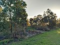 A bushland in the park's southern vicinity.
 -
 Cumberland Highway as seen from the Brenan Park walking track.
 -
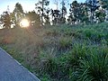 A sloped shrubby area near the walking track to the south of the park.


See also
 New South Wales portal
 Environment portal


- Wetherill Park Nature Reserve
- Fairfield Park Precinct
- Western Sydney Parklands
- Central Gardens Nature Reserve
- Rosford Street Reserve
References
- ^ a b Michael King & Associates (1997). Recreation Needs Assessment Study prepared for Fairfield City Council.
- ^ Know your suburb. Fairfield City Council. February 1999.
{{cite book}}:|work=ignored (help) - ^ George, V. (1991). Fairfield – A History of the District (Second ed.). Fairfield City Council.
- ^ Clouston (1999). Fairfield Open Space Strategy prepared for Fairfield City Council.
- ^ Strategic Plan for Fairfield City 1999-2010. Fairfield City Council. 1999.
- ^ Local Environment Plan. Fairfield City Council. 1994.
- ^ Woodward Clyde Environmental Consultants (1992). Environmental reports in Brenan Park Property Files for Fairfield City Council.
- ^ Management Plan for Fairfield City 1999-2003. Fairfield City Council. 1999.
- ^ Fairley, A.; Moore, P. (1995). Native Plants of Sydney District – an identification guide. Sydney: Kangaroo Press.
- ^ Vision for Fairfield. Fairfield City Council. December 1999.
- v
- t
- e
Sydney landmarks
- Admiralty House
- Archibald Fountain
- Australia Square
- Bankstown Reservoir
- Boothtown Aqueduct
- Cadmans Cottage
- Campbell's Stores
- The Cenotaph
- Central station
- Chifley Tower
- Citigroup Centre
- International Convention Centre
- Deutsche Bank Place
- Dr Chau Chak Wing Building
- El Alamein Fountain
- Finger Wharf
- General Post Office (No. 1 Martin Place)
- Government House
- Governor Phillip Tower
- Hong Kong House
- Hyde Park Barracks
- King Street Wharf
- Kirribilli House
- Long Bay
- Macquarie Lighthouse
- Mint
- Observatory
- Old Government House
- Old Mining Museum Building
- Opera House
- Overseas Passenger Terminal
- Parliament House
- Parramatta Gaol
- Regimental Square
- The Ribbon
- Queen Victoria Building
- St Andrew's Cathedral
- St Mary's Cathedral
- Sydney Airport
- Sydney Tower
- The Toaster
- Town Hall
- War Memorial
- Warragamba Dam
- White Bay Cruise Terminal
- World Square
- World Tower
- Auburn Botanic Gardens
- Balaka Falls
- Balls Head Reserve
- Bents Basin
- Berowra Valley National Park
- Bicentennial Park
- Bland Oak
- Blue Mountains National Park
- Brenan Park
- Centennial Parklands
- Central Gardens Nature Reserve
- Chinese Garden of Friendship
- Chipping Norton Lake
- Cronulla sand dunes
- Fairfield Park Precinct
- Farm Cove
- Featherdale Wildlife Park
- Field of Mars Reserve
- Fred Hollows Reserve
- Garigal National Park
- Garawarra Conservation Area
- Georges River National Park
- Heathcote National Park
- Hyde Park
- Kamay Botany Bay National Park
- Ku-ring-gai Chase
- Lake Parramatta
- Lane Cove National Park
- Macquarie Place
- Mrs Macquarie's Chair
- Paddington Reservoir
- Parramatta Park
- Prospect dolerite intrusion
- Prospect Hill
- Prospect Nature Reserve
- Rosford Street Reserve
- Royal Botanic Garden
- Royal National Park
- Sydney Harbour National Park
- Sydney Park
- The Domain
- Western Sydney Parklands
- Western Sydney Regional Park
- Wetherill Park Nature Reserve
- Art Gallery of New South Wales
- Australian Museum
- Australian National Maritime Museum
- Chau Chak Wing Museum
- Harry's Cafe de Wheels
- Manly Art Gallery and Museum
- Museum of Contemporary Art
- Museum of Sydney
- Justice and Police Museum
- Powerhouse Museum
- Sea Life Sydney Aquarium
- State Library
- Sydney Conservatorium of Music
- Sydney Zoo
- Taronga Zoo
- Australian Golf Club
- Canterbury Park Racecourse
- Dunc Gray Velodrome
- Lakes Golf Club
- Macquarie Ice Rink
- Randwick Racecourse
- Rosehill Gardens Racecourse
- Royal Sydney Golf Club
- Stadium Australia
- State Sports Centre
- Sydney Cricket Ground
- Sydney Football Stadium
- Sydney International Regatta Centre
- Sydney Motorsport Park
- Sydney Olympic Park
- Sydney Olympic Park Athletic Centre
- Sydney Olympic Park Aquatic Centre
- Sydney Olympic Park Hockey Centre
- Sydney Olympic Park Tennis Centre
- Sydney Showground Stadium
- Warwick Farm Racecourse
- Wentworth Park
- Western Sydney International Dragway
- Western Sydney Stadium
- Bare
- Clark
- Cockatoo
- Fort Denison
- Garden
- Goat
- Rodd
- Shark
- Snapper
- Spectacle


