Farm Cove, New South Wales

Farm Cove is a tidal inlet and shallow bay in Sydney Harbour, separated from Sydney Cove by Bennelong Point, New South Wales, Australia (site of the Sydney Opera House). Farm Cove is one of the places around Sydney Harbour that has been officially gazetted as a dual named site by the Geographical Names Board (GNB). The official dual name for this place is: 'Farm Cove / Wahganmuggalee'.[1][2]
Known to the indigenous inhabitants of Sydney as Woccanmagully, Farm Cove was used by them as an initiation ground and for the "Kangaroo and Dog Dance". The land immediately adjacent to Farm Cove was set aside soon after first European settlement in 1788 by Governor Arthur Phillip for the Government House Domain, a private reserve for the NSW Governor. The first farm for the colony was thereafter established in the area, subsequently lending its name to the cove.[3] After the failure of this first farm, and the transfer of agricultural efforts elsewhere in the colony, Governor Lachlan Macquarie established the Royal Botanic Garden, Sydney around Farm Cove in 1816. Farm Cove was used as an anchorage for Royal Navy, Royal Australian Navy and visiting naval vessels until the 1960s.[4]
On 3 February 1954, Farm Cove was the site of where Queen Elizabeth II, Queen of Australia, landed at the beginning of her first visit to Australia. It was the first occasion on which a reigning monarch had set foot on Australian soil.
Gallery
-
 Farm Cove.
 -
 Yachts out in the harbour.
 -
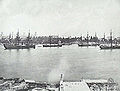 Ships of the Royal Navy's Squadron on the Australia Station moored in Farm Cove.


See also
- Geography of Sydney
Notes
- ^ Troy, Jakelin; Walsh, Michael (1 October 2009), "Reinstating Aboriginal placenames around Port Jackson and Botany Bay", Aboriginal Placenames. Naming and re-naming the Australian landscape, ANU Press, doi:10.22459/ap.10.2009.03, ISBN 978-1-921666-08-7
- ^ "Language |". www.sydneybarani.com.au. Retrieved 12 July 2021.
- ^ Royal Botanic Garden History
- ^ Gillett, p.21.
References
- Gillett, Ross; Melliar-Phelps, Michael (1980). A Century of Ships in Sydney Harbour. Rigby Publishers Ltd. ISBN 0-7270-1201-0.
External links
Wikimedia Commons has media related to Farm Cove, New South Wales.
- v
- t
- e
Sydney landmarks
- Admiralty House
- Archibald Fountain
- Australia Square
- Bankstown Reservoir
- Boothtown Aqueduct
- Cadmans Cottage
- Campbell's Stores
- The Cenotaph
- Central station
- Chifley Tower
- Citigroup Centre
- International Convention Centre
- Deutsche Bank Place
- Dr Chau Chak Wing Building
- El Alamein Fountain
- Finger Wharf
- General Post Office (No. 1 Martin Place)
- Government House
- Governor Phillip Tower
- Hong Kong House
- Hyde Park Barracks
- King Street Wharf
- Kirribilli House
- Long Bay
- Macquarie Lighthouse
- Mint
- Observatory
- Old Government House
- Old Mining Museum Building
- Opera House
- Overseas Passenger Terminal
- Parliament House
- Parramatta Gaol
- Regimental Square
- The Ribbon
- Queen Victoria Building
- St Andrew's Cathedral
- St Mary's Cathedral
- Sydney Airport
- Sydney Tower
- The Toaster
- Town Hall
- War Memorial
- Warragamba Dam
- White Bay Cruise Terminal
- World Square
- World Tower
- Auburn Botanic Gardens
- Balaka Falls
- Balls Head Reserve
- Bents Basin
- Berowra Valley National Park
- Bicentennial Park
- Bland Oak
- Blue Mountains National Park
- Brenan Park
- Centennial Parklands
- Central Gardens Nature Reserve
- Chinese Garden of Friendship
- Chipping Norton Lake
- Cronulla sand dunes
- Fairfield Park Precinct
- Farm Cove
- Featherdale Wildlife Park
- Field of Mars Reserve
- Fred Hollows Reserve
- Garigal National Park
- Garawarra Conservation Area
- Georges River National Park
- Heathcote National Park
- Hyde Park
- Kamay Botany Bay National Park
- Ku-ring-gai Chase
- Lake Parramatta
- Lane Cove National Park
- Macquarie Place
- Mrs Macquarie's Chair
- Paddington Reservoir
- Parramatta Park
- Prospect dolerite intrusion
- Prospect Hill
- Prospect Nature Reserve
- Rosford Street Reserve
- Royal Botanic Garden
- Royal National Park
- Sydney Harbour National Park
- Sydney Park
- The Domain
- Western Sydney Parklands
- Western Sydney Regional Park
- Wetherill Park Nature Reserve
- Art Gallery of New South Wales
- Australian Museum
- Australian National Maritime Museum
- Chau Chak Wing Museum
- Harry's Cafe de Wheels
- Manly Art Gallery and Museum
- Museum of Contemporary Art
- Museum of Sydney
- Justice and Police Museum
- Powerhouse Museum
- Sea Life Sydney Aquarium
- State Library
- Sydney Conservatorium of Music
- Sydney Zoo
- Taronga Zoo
- Australian Golf Club
- Canterbury Park Racecourse
- Dunc Gray Velodrome
- Lakes Golf Club
- Macquarie Ice Rink
- Randwick Racecourse
- Rosehill Gardens Racecourse
- Royal Sydney Golf Club
- Stadium Australia
- State Sports Centre
- Sydney Cricket Ground
- Sydney Football Stadium
- Sydney International Regatta Centre
- Sydney Motorsport Park
- Sydney Olympic Park
- Sydney Olympic Park Athletic Centre
- Sydney Olympic Park Aquatic Centre
- Sydney Olympic Park Hockey Centre
- Sydney Olympic Park Tennis Centre
- Sydney Showground Stadium
- Warwick Farm Racecourse
- Wentworth Park
- Western Sydney International Dragway
- Western Sydney Stadium
- Bare
- Clark
- Cockatoo
- Fort Denison
- Garden
- Goat
- Rodd
- Shark
- Snapper
- Spectacle
33°51′40″S 151°13′08″E / 33.86111°S 151.21889°E / -33.86111; 151.21889
 | This article related to the geography of Sydney is a stub. You can help Wikipedia by expanding it. |
- v
- t
- e


