Calaveras Reservoir
Reservoir in California, US
37°28′43″N 121°49′21″W / 37.4785°N 121.8226°W / 37.4785; -121.8226Calaveras Creek
(replaced 2019; 5 years ago (2019))


Calaveras Reservoir is located primarily in Santa Clara County, California, with a small portion and its dam in Alameda County, California. In Spanish, Calaveras means "skulls".
The reservoir is fed mainly by Arroyo Hondo and Calaveras Creek. Lying in the Calaveras Valley, the region is geologically active with the Calaveras Fault parallel to and to the west of the dam site. The seismic hazard forced replacement of the original dam. The replacement dam began construction in 2011 and was completed in 2019.
The Calaveras Valley has diverse wildlife including deer, coyotes, squirrels, turkey vultures, red-winged blackbirds, yellow-billed magpies, red-tailed hawks, brewer's blackbirds, purple martins, barn swallows, bullock's orioles, and warblers. Since at least 2008, a pair of bald eagles has nested regularly.[3]
History
In the 19th century, the Calaveras Valley which the reservoir now fills was primarily an agricultural region known for its production of hay, strawberries, and tomatoes. Because of San Francisco's increasing demand for drinking water at the turn of the 20th century, the farmers in the region were forced to sell their land to the Spring Valley Water Company, which in turn sold it to the San Francisco Water Company.
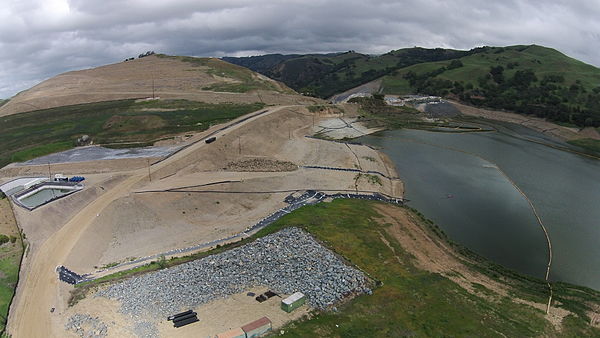
The first dam on the site, built in 1913 by the Spring Valley Water Company, rapidly changed the sensitive hydrology and natural environment of the Calaveras Valley. That dam suffered a collapse of the upstream slope in 1918 due to design and material flaws.[4] Its replacement, which stood until 2019, was the largest earth-fill dam in the world when completed in 1925. It was 245 feet high, with a length of 1200 feet at its crest.[5] The city and county of San Francisco owns and operates the dam and reservoir for municipal water supply. Due to concerns about its seismic rating, the 1925 dam was replaced by a new dam constructed just downstream from 2014 to 2019.

The reservoir is reported to contain a large population of largemouth bass, rainbow trout and other species. However, fishing is prohibited.[citation needed]
The San Francisco Public Utilities Commission (SFPUC) owns 36,000 acres (150 km2) in the Alameda Creek Watershed. Some lands in the watershed are leased to livestock companies for cattle ranching to control vegetation and prevent fires. Most of the land is closed to the public because of concerns over drinking water safety and quality.
Dam replacement
The dam site has an active earthquake fault nearby, and the original 1925 dam was seismically vulnerable. If the dam had collapsed when full, it would have flooded parts of Fremont, California with a wall of water 30 ft (9.1 m) high. Dam regulators for the state of California restricted the capacity of the original dam in 2001, to mitigate the seismic threat. The capacity of the original dam was limited to about one-third of the nominal 100,000 acre-feet (120 million cubic meters).[6]
To restore lost capacity, the San Francisco Public Utilities Commission constructed a replacement dam located 1,000 ft (300 m) downstream from the original 1925 dam. The dam replacement took twice as long (eight years instead of four years) and cost twice as much as originally scheduled. Hazardous geological conditions were discovered near the proposed west abutment in 2012 and near the proposed spillway. The dam site was weakened by at least two ancient landslides.[7][8][9] When construction started in 2011, the budget was $420 million, and completion was expected in 2015.[10] The seismic redesign required three million additional cubic yards (two million cubic meters) of excavation, far more than the original seven million cubic yards (five million cubic meters).[7][8] The spillway had to be relocated away from one of the ancient landslides, delaying the project by another year.[9] As of 2017, the completion had been pushed back to spring or summer 2019, and the cost had risen to $810 million.[11][9]
The design of the replacement dam allows for future capacity expansion, and the core is wider than needed initially. The design allows the height to be raised by 150 ft (46 m), to quadruple the initial capacity of 100,000 acre⋅ft (120,000,000 m3).[9] On completion of the replacement dam, a third of the old dam was removed to allow the reservoir to be impounded by the new dam instead.
The construction project allocated funds to restore populations of native fish in other parts of the watershed. A ladder for Steelhead trout (Oncorhynchus mykiss) at the dam itself was deemed infeasible. At 290 feet (88 m), it would have been the tallest fish ladder in the US and would have cost $40 million.[12] The SFPUC did assure environmental groups that it will release water from the replacement dam to improve summer flows. A smaller fish ladder is under construction at a separate diversion dam on upper Alameda Creek, regarded as prime trout habitat.[6]
Ecology
Facing legal challenges to release flows to support steelhead trout (Oncorhynchus mykiss) in the 20 miles (32 km) of Calaveras Creek below the dam, the San Francisco Public Utilities Commission (SFPUC) began steady releases after the dam was re-built in 2018. The steady flow releases, and accompanying lowered water temperatures, resulted in a sharp increase in the numbers of trout.[13]
Plane crash discovery
In the late 1980s and early 1990s, a drought affected California, and water levels in reservoirs throughout the state became extraordinarily low. By January 1991, the water at the reservoir was down 100 feet (30 m), and the aluminum body of an airplane became visible. Two skeletons were found at the site on January 5, 1991. Dental records and the plane's serial number were used to positively identify the remains as Clifford Gillman and his single-engine Ercoupe, along with Gillman's friend Robert Louviere. They had been missing since June 16, 1963. The wreck, minus the two men's remains, is still lying in the center of the reservoir.[14]
See also
- Arroyo Hondo (Santa Clara County, California)
- Black Mountain (Milpitas, California)
- List of dams and reservoirs in California
- List of lakes in California
References
- ^ California, State of. "Dam Profile for". cdec.water.ca.gov. Retrieved 23 April 2018.
- ^ "Calaveras Reservoir". Geographic Names Information System. United States Geological Survey, United States Department of the Interior.
- ^ Von Rospach, Chuq. "Calaveras Bald Eagle Nest 2013". Chuq von Rospach: Stories Told Here. Archived from the original on February 22, 2014. Retrieved February 16, 2014.
- ^ Dorsey, C (January 30, 2006). "The Construction and Failure of Calaveras Dam" (PDF). State of California Dept of Water Resources. Retrieved March 15, 2018.
- ^ "Archived copy". Archived from the original on 2014-04-07. Retrieved 2012-09-26.
{{cite web}}: CS1 maint: archived copy as title (link) - ^ a b Kelly Zito (January 28, 2011). "Calaveras Dam rebuilding projected approved". San Francisco Chronicle. Retrieved February 2, 2011.
- ^ a b Fimrite, Peter (April 22, 2013). "Calaveras Dam runs into worrisome delay". San Francisco Chronicle. Retrieved March 15, 2018.
- ^ a b "Calaveras Dam Replacement Project Winter Update". San Francisco Public Utilities Commission. December 10, 2012. Retrieved March 15, 2018.
- ^ a b c d "Moving Mountains Replacement dam near Calaveras Fault strengthens San Francisco's water-supply system" (PDF). ENR Engineering News Record magazine. November 20, 2017. Archived from the original (PDF) on March 25, 2018. Retrieved March 15, 2018.
- ^ Fimrite, Peter (September 16, 2011). "Calaveras Dam replacement to begin amid retrofit". San Francisco Chronicle. Retrieved March 15, 2018.
- ^ Fracassa, Dominic (November 23, 2017). "New star of SF's water system: Calaveras Dam touted as model of safety, efficiency". San Francisco Chronicle. Retrieved March 15, 2018.
- ^ "Calaveras Dam Project Revised, Future Operations Could Help Restore Alameda Creek" (PDF). Alameda Creek Alliance. January 25, 2011. Archived from the original (PDF) on July 22, 2011. Retrieved February 2, 2011.
- ^ Alastair Bland. "Dam Tweaks Yield Results" (PDF). San Francisco Estuary Magazine. Retrieved March 27, 2020.
- ^ "Father's Day Disappearance". Check-Six.com.
- Loomis, Patricia. Milpitas: A Century of Little Cornfields
External links
- San Francisco Water Sources, including Calaveras Reservoir
- v
- t
- e

- Major
- San Francisco Bay
- Suisun Bay
- San Pablo Bay
- Minor
- Golden Gate
- Grizzly Bay
- Richardson Bay
- San Rafael Bay
- Richmond Inner Harbor
- San Leandro Bay
- Former
- Yerba Buena Cove
- Mission Bay
- Rivers
- San Joaquin
- Sacramento
- Napa
- Guadalupe
- Petaluma
- Creeks (discharging into the Bay)
- Alameda
- Baxter
- Cerrito
- Codornices
- Coyote (Santa Clara)
- Coyote (Marin)
- San Leandro
- San Lorenzo
- Schoolhouse
- Temescal
- Sausal
- Redwood
- San Mateo
- Sonoma
- Corte Madera
- Arroyo Corte Madera del Presidio
- San Rafael
- Miller
- Novato
- Tolay
- San Francisquito
- Pacheco
- Alhambra
- Adobe
- Rodeo
- Refugio
- Pinole
- Garrity
- Rheem
- Karlson
- San Pablo
- Castro
- Wildcat
- Fluvius Innominatus
- Marin (Alameda County)
- Strawberry
- Easton
- Mission Creek
- Reservoirs
- Calaveras Reservoir
- Lafayette Reservoir
- Straits and estuaries
- Clifton Court Forebay
- Carquinez Strait
- Oakland Estuary
- Raccoon Strait
- Sacramento–San Joaquin River Delta
- Stockton Deepwater Shipping Channel
- Watersheds
- Laguna Creek Watershed
- Guadalupe watershed
protected areas
- Don Edwards National Wildlife Refuge
- San Pablo Bay National Wildlife Refuge
- Eden Landing Ecological Reserve
- Hayward Regional Shoreline
- Hayward Shoreline Interpretive Center
- Crown Memorial State Beach
- McLaughlin Eastshore State Park
- Emeryville Crescent State Marine Reserve
- Point Isabel Regional Shoreline
- César Chávez Park
- Brooks Island Regional Preserve
- Point Pinole Regional Shoreline
- Antioch Dunes National Wildlife Refuge
- Coyote Point Recreation Area
- Middle Harbor Shoreline Park
- National Estuarine Research Reserve
- China Camp State Park
- San Francisco Maritime National Historical Park
- SF Bay Trail
- Oyster Bay Regional Shoreline
- Big Break Regional Shoreline
- Palo Alto Baylands Nature Preserve
peninsulas
- Major islands
- Alameda
- Alcatraz
- Angel
- Treasure Island
- Yerba Buena
- Minor
- Brooks
- Bair
- Bay Farm
- Belvedere
- Brother
- Castro Rocks
- Coast Guard
- Greco
- Hooks Island
- Mare
- Red Rock
- The Sisters
- Marin Islands
- Roe
- Ryer
- Seal Islands
- Peninsulas/infill
- Albany Bulb
- Brisbane Baylands
- Point Isabel
- Foster City
- Fleming Point
- Hunters Point
- Sierra Point
- Steamboat Point
and tubes
marinas
- History
- Delta and Dawn
- Discovery Site
- Humphrey the Whale
- San Leandro Oyster Beds
- Richmond Shipyards
- U.S. Army Corps of Engineers Bay Model
- Harold Gilliam
- Marincello
- Ecology
- Golden Gate Biosphere Reserve
- Cosco Busan oil spill
- Thicktail chub
- Delta smelt
- Conservation and Development Commission
- The Watershed Project
- Save The Bay
- Citizens for East Shore Parks
- Friends of Five Creeks
- Urban Creeks Council
- 1971 oil spill
- Greenbelt Alliance
- The Bay Institute
- Reber Plan
- San Francisco Baykeeper
- San Francisco Estuary and Watershed Science
- Estuary Partnership
- Transportation
- Water Trail
- Transportation in the San Francisco Bay Area
 Portal
 Category


