Middle Harbor Shoreline Park
| Middle Harbor Shoreline Park | |
|---|---|
 Middle Harbor Shoreline Park in the Port of Oakland | |
 | |
| Location | Oakland Bay/Alameda County, California |
| Nearest city | Oakland, California |
| Area | 38 acres (15 ha)[1] |
| Created | 2004 |
| Operated by | Port of Oakland[1] |
| Open | Monday - Friday |
Middle Harbor Shoreline Park (MHSP) is located on San Francisco Bay and the Oakland Seaport entrance channel, west of downtown Oakland, California.[2] It is owned and operated by the Port of Oakland. The park entrance is at the intersection of 7th Street and Middle Harbor Road. It is open seven days a week from 8 a.m. to dusk.[1]
History
The park is primarily on land that was the former site of the Oakland Naval Supply Depot (1940−1998), which was an important supply base for the Pacific Fleet of the U. S. Navy throughout World War II. The Naval Supply Depot closed in 1998, and the 541 acres (2.19 km2) facility was transferred to the Port of Oakland, which still owns it.[1]
The section adjacent to the Port of Oakland, which includes Port View Park, was originally part of the Oakland Long Wharf or Oakland Pier−Mole, which was the massive western terminus of the Southern Pacific Railroad into San Francisco Bay. The interlocking tower from the railroad's pier has been moved and partially restored as a small commemorative museum. The mast of the USS Oakland is displayed at the entrance of the park.[1]
Additionally, parts of the park used to be the Western Pacific Mole, a former railroad station/ferry pier of the Western Pacific Railroad. Before the WP transferred its operations to the Oakland Long Wharf, passengers can transfer from WP trains to ferries to San Francisco. The Mole was demolished in 1940, and its land is now part of the MHSP.[3]
| Former services at Western Pacific Mole | ||||
|---|---|---|---|---|
| Preceding station | Western Pacific Railroad | Following station | ||
| Terminus | Feather River Route (1910 to 1933) | Oakland towards Salt Lake City | ||
A 38 acres (0.15 km2) area was redeveloped for the park from 2002 to 2004. Redevelopment of the land included restoration of beaches and creation of a lagoon.[1] The park was opened to the public on September 18, 2004.[4]
Features
- There is an amphitheater overlooking San Francisco Bay where live entertainment performs.
- The Chappell R. Hayes Memorial Observation Tower, named to honor the West Oakland leader, offers good views of the Oakland Estuary and the Port's shipping activities.
- Interpretive signs throughout the park present the history of the site, the environmental resources here and the adjacent maritime activities.[1]
- A viewing area for observing the super-Panamax cranes in operation at the adjacent Hanjin Terminal.[4]
Accessibility
The following facilities are wheelchair accessible:
- Parking lots
- Restrooms
- Drinking fountains
- Picnic sites
- Port View Park
- Observation Tower
- Viewing area at Western Pacific Mole
Rules
- The park is open from 8:00 a.m. to dusk 7 days a week, all year. It is closed from dusk to dawn, except for special events authorized by Park Use Permit.
- The park will only be closed to the public during special events. Those are conducted no more than 3 times per year, and advance notification is posted.
- Dogs are not allowed within the park, except that Service Dogs ON-LEASH ONLY are permitted on trails and parkland areas (Oakland Municipal Code).
Gallery
-
 Middle Harbor Shoreline Park, with the mast of USS Oakland in the distance.
 -
 Playground in the park.
 -
 Shaded picnic area in the park.
 -
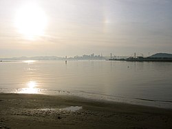 View of beach area and San Francisco from the park.
 -
 Gantry cranes at the adjacent Hanjin Terminal, Port of Oakland.


References
- ^ a b c d e f g "Middle Harbor Shoreline Park." Port of Oakland. 2017. Accessed August 31, 2017.
- ^ EBRPD: Middle Harbor Shoreline Park
- ^ "Western Pacific Mole - Oakland - CA - US". Historical Marker Project. Retrieved 27 May 2024.
- ^ a b "Middle Harbor Shoreline Park / Port View Park" Waterfront Action. 2005. Accessed September 5, 2017.
External links
Wikimedia Commons has media related to Middle Harbor Shoreline Park.
- Official website
- Map: 37°48′21″N 122°19′27″W / 37.80583°N 122.32417°W / 37.80583; -122.32417
- v
- t
- e

- Major
- San Francisco Bay
- Suisun Bay
- San Pablo Bay
- Minor
- Golden Gate
- Grizzly Bay
- Richardson Bay
- San Rafael Bay
- Richmond Inner Harbor
- San Leandro Bay
- Former
- Yerba Buena Cove
- Mission Bay
- Rivers
- San Joaquin
- Sacramento
- Napa
- Guadalupe
- Petaluma
- Creeks (discharging into the Bay)
- Alameda
- Baxter
- Cerrito
- Codornices
- Coyote (Santa Clara)
- Coyote (Marin)
- San Leandro
- San Lorenzo
- Schoolhouse
- Temescal
- Sausal
- Redwood
- San Mateo
- Sonoma
- Corte Madera
- Arroyo Corte Madera del Presidio
- San Rafael
- Miller
- Novato
- Tolay
- San Francisquito
- Pacheco
- Alhambra
- Adobe
- Rodeo
- Refugio
- Pinole
- Garrity
- Rheem
- Karlson
- San Pablo
- Castro
- Wildcat
- Fluvius Innominatus
- Marin (Alameda County)
- Strawberry
- Easton
- Mission Creek
- Reservoirs
- Calaveras Reservoir
- Lafayette Reservoir
- Straits and estuaries
- Clifton Court Forebay
- Carquinez Strait
- Oakland Estuary
- Raccoon Strait
- Sacramento–San Joaquin River Delta
- Stockton Deepwater Shipping Channel
- Watersheds
- Laguna Creek Watershed
- Guadalupe watershed
protected areas
- Don Edwards National Wildlife Refuge
- San Pablo Bay National Wildlife Refuge
- Eden Landing Ecological Reserve
- Hayward Regional Shoreline
- Hayward Shoreline Interpretive Center
- Crown Memorial State Beach
- McLaughlin Eastshore State Park
- Emeryville Crescent State Marine Reserve
- Point Isabel Regional Shoreline
- César Chávez Park
- Brooks Island Regional Preserve
- Point Pinole Regional Shoreline
- Antioch Dunes National Wildlife Refuge
- Coyote Point Recreation Area
- Middle Harbor Shoreline Park
- National Estuarine Research Reserve
- China Camp State Park
- San Francisco Maritime National Historical Park
- SF Bay Trail
- Oyster Bay Regional Shoreline
- Big Break Regional Shoreline
- Palo Alto Baylands Nature Preserve
peninsulas
- Major islands
- Alameda
- Alcatraz
- Angel
- Treasure Island
- Yerba Buena
- Minor
- Brooks
- Bair
- Bay Farm
- Belvedere
- Brother
- Castro Rocks
- Coast Guard
- Greco
- Hooks Island
- Mare
- Red Rock
- The Sisters
- Marin Islands
- Roe
- Ryer
- Seal Islands
- Peninsulas/infill
- Albany Bulb
- Brisbane Baylands
- Point Isabel
- Foster City
- Fleming Point
- Hunters Point
- Sierra Point
- Steamboat Point
and tubes
marinas
- History
- Delta and Dawn
- Discovery Site
- Humphrey the Whale
- San Leandro Oyster Beds
- Richmond Shipyards
- U.S. Army Corps of Engineers Bay Model
- Harold Gilliam
- Marincello
- Ecology
- Golden Gate Biosphere Reserve
- Cosco Busan oil spill
- Thicktail chub
- Delta smelt
- Conservation and Development Commission
- The Watershed Project
- Save The Bay
- Citizens for East Shore Parks
- Friends of Five Creeks
- Urban Creeks Council
- 1971 oil spill
- Greenbelt Alliance
- The Bay Institute
- Reber Plan
- San Francisco Baykeeper
- San Francisco Estuary and Watershed Science
- Estuary Partnership
- Transportation
- Water Trail
- Transportation in the San Francisco Bay Area
 Portal
 Category


