Horn Peak
Mountain in the state of Colorado


Horn Peak
Location in Colorado
Show map of Colorado
Horn Peak
Horn Peak (the United States)
Show map of the United StatesSangre de Cristo Range[5]
Northeast ridge or West ridge[2]
Horn Peak is a 13,450-foot (4,100 m) mountain summit in Custer County, Colorado, United States.
Description
Horn Peak is set in the Sangre de Cristo Range which is a subrange of the Rocky Mountains. It is the 14-highest summit in Custer County,[6] and can be seen from Highway 69 near the community of Westcliffe. The mountain is located in the Sangre de Cristo Wilderness on land managed by San Isabel National Forest.[5] Precipitation runoff from the mountain's slopes drains into tributaries of Grape Creek which in turn is a tributary of the Arkansas River. Topographic relief is significant as the summit rises 2,250 feet (686 m) above Cottonwood Creek in 0.6 mile (1 km). An ascent of the peak involves nine miles (14 km) of strenuous hiking.[1] The mountain's toponym has been officially adopted by the United States Board on Geographic Names.[4]
Climate
According to the Köppen climate classification system, Horn Peak is located in an alpine subarctic climate zone with cold, snowy winters, and cool to warm summers.[7] Due to its altitude, it receives precipitation all year, as snow in winter, and as thunderstorms in summer, with a dry period in late spring.
Gallery
-
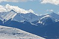
 Left to right: Little Horn Peak, Fluted Peak, Horn Peak
 -
 Sangre de Cristo Range viewed from Hardscrabble Pass. Horn Peak centered, Mount Adams is the highest peak to left, and Fluted Peak between those two.
 -
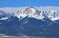 Horn Peak
 -
 Horn Peak (left) and Comanche Peak (right)
 -
 Sangre de Cristo Range with road pointed at Horn Peak


See also
- Sangre de Cristo Mountains
 Mountains portal
- Thirteener

References
- ^ a b Lee Hart (2016), Hiking Colorado's Sangre de Cristos and Great Sand Dunes, Falcon Guides, ISBN 9781493023813, p. 97.
- ^ a b Robert M. Ormes (2000), Guide to the Colorado Mountains, Colorado Mountain Club Press, ISBN 9780967146607, p. 105.
- ^ a b c d "Horn Peak – 13,454' CO". listsofjohn.com. Retrieved May 3, 2023.
- ^ a b "Horn Peak". Geographic Names Information System. United States Geological Survey, United States Department of the Interior. Retrieved May 3, 2023.
- ^ a b "Horn Peak, Colorado". Peakbagger.com. Retrieved May 3, 2023.
- ^ "Horn Peak, Peakvisor.com". Retrieved May 3, 2023.
- ^ Peel, M. C.; Finlayson, B. L.; McMahon, T. A. (2007). "Updated world map of the Köppen−Geiger climate classification". Hydrol. Earth Syst. Sci. 11. ISSN 1027-5606.
External links
- Horn Peak: weather forecast
Places adjacent to Horn Peak | ||||||||||||||||
|---|---|---|---|---|---|---|---|---|---|---|---|---|---|---|---|---|
| ||||||||||||||||


- v
- t
- e

- Mount Garfield
- Aspen Mountain
- Capitol Peak
- Castle Peak
- Cathedral Peak
- Chair Mountain
- Crested Butte
- Gothic Mountain
- Italian Mountain
- Maroon Bells
- Mount Emmons
- Mount Owen
- Mount Sopris
- Pyramid Peak
- Snowmass Mountain
- Snowmass Peak
- Treasure Mountain
- Black Mountain (Moffat County)
- Columbus Mountain
- Elk Mountain (Routt County)
- Hahns Peak
- Flat Top Mountain
- Sleepy Cat Peak
- Eagles Nest
- Jacque Peak
- Meridian Peak
- Mount Powell
- The Spider
- Crater Peak
- North Mamm Peak
- Clark Peak
- Arkansas Hills
- Clinton Peak
- Dyer Mountain
- Gemini Peak
- Horseshoe Mountain
- Mount Arkansas
- Mount Bross
- Mount Buckskin
- Mount Democrat
- Mount Lincoln
- Mount Sheridan
- Mount Sherman
- Pacific Peak
- West Buffalo Peak
- Elk Mountain (Grand County)
- Parkview Mountain
- Radial Mountain
- Whiteley Peak
| Sangre de Cristo Range |
|
|---|---|
| Wet Mountains |
|
| Others |
|
| Collegiate Peaks |
|
|---|---|
| Others |
|
- Crystal Peak
- Fletcher Mountain
- Peak 10
- Peak One
- Quandary Peak
- Tenmile Peak
- Bear Mountain
- Blair Mountain
- Chalk Mountains
- Cochetopa Hills
- Dawson Butte
- Diamond Peak
- Flirtation Peak
- Granite Peak
- Grand Hogback
- Grannys Nipple
- Horsefly Peak
- Lead Mountain (Grand County)
- Mount Neva
- Powell Peak
- San Luis Hills
- Storm King Mountain
- Terrible Mountain
- Two Buttes
- Ute Mountain


