Horsetooth Mountain
Mountain in Colorado, United States


Horsetooth Mountain
Colorado
Horsetooth Reservoir, Colorado[1]
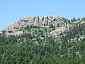
Horsetooth Mountain is a mountain summit in the foothills of the Front Range of the Rocky Mountains of North America. The 7,259-foot (2,213 m) peak is located in the Horsetooth Mountain Open Space, 7.0 miles (11.2 km) west (bearing 265°) of downtown Fort Collins in Larimer County, Colorado, United States.[1][2][3][4]
Mountain
The mountain is easily distinguishable by the large pegmatite rock formation on its summit known as Horsetooth Rock. The formation is a prominent landmark of the nearby city of Fort Collins and often used as a symbol of that city, appearing in the official city seal. The name comes from its distinctive appearance.
The site was previously private property owned by the Soderburg family. In 1982, it was purchased by the county as an "open space" tax acquisition. It is now a popular destination for hikers as well as mountain bikers, with trails leading to the summit. The summit offers hikers a clear view to the southwest of Longs Peak and Mount Meeker, two rugged mountains in Rocky Mountain National Park.
A daily entrance permit costs $10 per vehicle.[5]
Wildlife
Horsetooth Mountain Park not only hosts some spectacular scenery, it is home to a variety of large mammals such as mule deer, American black bears, mountain lions and coyotes.
Gallery
-
 Top of Horsetooth Mountain facing West to the Rocky Mountains.
 -
 Cellphone towers visible from the top.
 -
 Fort Collins visible from the top.
 -
 Horsetooth Rock Trail.
 -
 Horsetooth Rock Trail near the beginning.
 -
 Near the trailhead.
 -
 Horsetooth Rock, named for the profile of its east face. Hikers are visible on the summit.
 -
 Upper Spring Creek valley on Horsetooth Mountain.


See also
 Geology portal
 Geography portal
 North America portal
 United States portal
 Colorado portal
 Mountains portal


- List of Colorado mountain ranges
- List of Colorado mountain summits
- List of Colorado county high points
References
- ^ a b c d "HORSETOOTH". NGS Data Sheet. National Geodetic Survey, National Oceanic and Atmospheric Administration, United States Department of Commerce. Retrieved November 4, 2014.
- ^ a b The elevation of Horsetooth Mountain includes an adjustment of +1.018 m (+3.34 ft) from NGVD 29 to NAVD 88.
- ^ a b c d "Horsetooth Mountain, Colorado". Peakbagger.com. Retrieved November 4, 2014.
- ^ a b "Horsetooth Mountain". Geographic Names Information System. United States Geological Survey, United States Department of the Interior. Retrieved November 4, 2014.
- ^ "Entrance Permits and Camping Prices". Larimer County. Retrieved 4 March 2020.
External links
Horsetooth Mountain at Wikipedia's sister projects
 Definitions from Wiktionary
 Media from Commons
 News from Wikinews
 Quotations from Wikiquote
 Texts from Wikisource
 Textbooks from Wikibooks
 Resources from Wikiversity
- "Horsetooth Mountain Open Space". Larimer County.
- v
- t
- e

- Mount Garfield
- Aspen Mountain
- Capitol Peak
- Castle Peak
- Cathedral Peak
- Chair Mountain
- Crested Butte
- Gothic Mountain
- Italian Mountain
- Maroon Bells
- Mount Emmons
- Mount Owen
- Mount Sopris
- Pyramid Peak
- Snowmass Mountain
- Snowmass Peak
- Treasure Mountain
- Black Mountain (Moffat County)
- Columbus Mountain
- Elk Mountain (Routt County)
- Hahns Peak
- Flat Top Mountain
- Sleepy Cat Peak
- Eagles Nest
- Jacque Peak
- Meridian Peak
- Mount Powell
- The Spider
- Crater Peak
- North Mamm Peak
- Clark Peak
- Arkansas Hills
- Clinton Peak
- Dyer Mountain
- Gemini Peak
- Horseshoe Mountain
- Mount Arkansas
- Mount Bross
- Mount Buckskin
- Mount Democrat
- Mount Lincoln
- Mount Sheridan
- Mount Sherman
- Pacific Peak
- West Buffalo Peak
- Elk Mountain (Grand County)
- Parkview Mountain
- Radial Mountain
- Whiteley Peak
| Sangre de Cristo Range |
|
|---|---|
| Wet Mountains |
|
| Others |
|
| Collegiate Peaks |
|
|---|---|
| Others |
|
- Crystal Peak
- Fletcher Mountain
- Peak 10
- Peak One
- Quandary Peak
- Tenmile Peak
- Bear Mountain
- Blair Mountain
- Chalk Mountains
- Cochetopa Hills
- Dawson Butte
- Diamond Peak
- Flirtation Peak
- Granite Peak
- Grand Hogback
- Grannys Nipple
- Horsefly Peak
- Lead Mountain (Grand County)
- Mount Neva
- Powell Peak
- San Luis Hills
- Storm King Mountain
- Terrible Mountain
- Two Buttes
- Ute Mountain


