José María Morelos Municipality
Municipality in Quintana Roo, Mexico

Flag


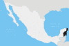
Location of Municipality in Quintana Roo
(2020 census)[1]
José María Morelos is one of the eleven municipalities that make up the Mexican state of Quintana Roo.
Geography
Like most of the Yucatan Peninsula José María Morelos is entirely flat with a gentle slope towards the sea, so from west to east.
Like the rest of the peninsula's surface the land has a limestone base that does not allow the formation of surface water flows such as rivers and streams, the water instead form flows in underground rivers that sometimes rise to the surface in cenotes. Lakes and cenotes are the major bodies of water in the municipality.
Communities
There were 129 populated localities, as well as 132 unpopulated localities enumerated during the 2010 census.
The largest localities (cities, towns, and villages) are:[1]

| Name | Population (2010 Census) |
|---|---|
| José María Morelos | 11,750 |
| Dziuché | 2,870 |
| Sabán | 2,167 |
| Huay Max | 1,399 |
| La Presumida | 1,357 |
| X-Cabil | 1,087 |
| Kancabchén | 1,083 |
| Sacalaca | 1,010 |
| Candelaria | 963 |
| Santa Gertrudis | 899 |
| Total municipality | 36,179 |
Demographics
| Year | Pop. | ±% p.a. |
|---|---|---|
| 1995 | 29,604 | — |
| 2000 | 31,052 | +0.96% |
| 2005 | 32,746 | +1.07% |
| 2010 | 36,179 | +2.01% |
| Source: INEGI Instituto Nacional de Estadística y Geografía[2] | ||
References
- ^ a b 2010 census tables: INEGI Archived 2013-05-02 at the Wayback Machine
- ^ INEGI. Instituto Nacional de Estadística y Geografía. Censo de Población y Vivienda 1995, 2000, 2005, 2010. Archived 2013-09-28 at the Wayback Machine
External links
 Media related to José María Morelos Municipality at Wikimedia Commons
- v
- t
- e
 State of Quintana Roo
Chetumal (capital)
- Bacalar (Bacalar)
- Benito Juárez (Cancún)
- Cozumel (San Miguel de Cozumel)
- Felipe Carrillo Puerto (Felipe Carrillo Puerto)
- Isla Mujeres (Isla Mujeres)
- José María Morelos (José María Morelos)
- Lázaro Cárdenas (Kantunilkín)
- Othón P. Blanco (Chetumal)
- Puerto Morelos (Puerto Morelos)
- Solidaridad (Playa del Carmen)
- Tulum (Tulum)
| Caves | |
|---|---|
| Islands | |
| Maya sites | |
| Reefs | |
| Other |


