National Register of Historic Places listings in Costilla County, Colorado
List of National Register of Historic Places in Costilla County, Colorado, United States

This is a list of the National Register of Historic Places listings in Costilla County, Colorado.
This is intended to be a complete list of the properties and districts on the National Register of Historic Places in Costilla County, Colorado, United States. The locations of National Register properties and districts for which the latitude and longitude coordinates are included below, may be seen in a map.[1]
There are 13 properties and districts listed on the National Register in the county. Another property was once listed but has been removed.
This National Park Service list is complete through NPS recent listings posted September 5, 2024.[2]
- v
- t
- e
Properties on the National Register of Historic Places in Colorado by county
- Adams
- Alamosa
- Arapahoe
- Archuleta
- Baca
- Bent
- Boulder
- Broomfield
- Chaffee
- Cheyenne
- Clear Creek
- Conejos
- Costilla
- Crowley
- Custer
- Delta
- Denver
- Dolores
- Douglas
- Eagle
- El Paso
- Elbert
- Fremont
- Garfield
- Gilpin
- Grand
- Gunnison
- Hinsdale
- Huerfano
- Jackson
- Jefferson
- Kiowa
- Kit Carson
- La Plata
- Lake
- Larimer
- Las Animas
- Lincoln
- Logan
- Mesa
- Mineral
- Moffat
- Montezuma
- Montrose
- Morgan
- Otero
- Ouray
- Park
- Phillips
- Pitkin
- Prowers
- Pueblo
- Rio Blanco
- Rio Grande
- Routt
- Saguache
- San Juan
- San Miguel
- Sedgwick
- Summit
- Teller
- Washington
- Weld
- Yuma

Map all coordinates using OpenStreetMap
Download coordinates as:
- KML
- GPX (all coordinates)
- GPX (primary coordinates)
- GPX (secondary coordinates)
Current listings
| [3] | Name on the Register[4] | Image | Date listed[5] | Location | City or town | Description |
|---|---|---|---|---|---|---|
| 1 | Capilla de San Isidro |  | July 23, 2013 (#13000523) | 21801 County Road K5 37°08′05″N 105°22′49″W / 37.134845°N 105.38027°W / 37.134845; -105.38027 (Capilla de San Isidro) | Los Fuertes | |
| 2 | Capilla de Viejo San Acacio |  | March 12, 2012 (#12000091) | 14152 County Road 14.8 37°12′06″N 105°30′31″W / 37.2018°N 105.5085°W / 37.2018; -105.5085 (Capilla de Viejo San Acacio) | Viejo San Acacio | Culebra River Villages of Costilla County Multiple Property Submission |
| 3 | Chama Sociedad Proteccion Mutua de Trabajadores Unidos (SPMDTU) Lodge Hall |  | December 31, 2018 (#100003273) | SW corner of County Rd. L7 (Whiskey Pass Rd.) and County Road 223 37°09′45″N 105°22′31″W / 37.162533°N 105.375207°W / 37.162533; -105.375207 (Chama Sociedad Proteccion Mutua de Trabajadores Unidos (SPMDTU) Lodge Hall) | Chama | Culebra River Villages of Costilla County Multiple Property Submission |
| 4 | Fort Garland |  | February 26, 1970 (#70000156) | On State Highway 159, 1 block south of U.S. Highway 160 37°25′18″N 105°25′50″W / 37.421667°N 105.430556°W / 37.421667; -105.430556 (Fort Garland) | Fort Garland | |
| 5 | Iglesia de la Inmaculada Concepcion |  | March 12, 2012 (#12000089) | 21529 County Road P.6 37°09′48″N 105°22′55″W / 37.1633°N 105.3819°W / 37.1633; -105.3819 (Iglesia de la Inmaculada Concepcion) | Chama | Culebra River Villages of Costilla County Multiple Property Submission |
| 6 | Iglesia de San Francisco de Assisi | 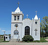 | March 27, 2012 (#12000144) | 23531 County Road J.2 37°06′09″N 105°20′57″W / 37.1024°N 105.3493°W / 37.1024; -105.3493 (Iglesia de San Francisco de Assisi) | San Francisco | Culebra River Villages of Costilla County Multiple Property Submission |
| 7 | Iglesia de San Pedro y San Pablo |  | March 12, 2012 (#12000090) | 11423 County Road 21 37°09′41″N 105°24′07″W / 37.161313°N 105.401808°W / 37.161313; -105.401808 (Iglesia de San Pedro y San Pablo) | San Pedro | Culebra River Villages of Costilla County Multiple Property Submission |
| 8 | Plaza de San Luis de la Culebra |  | December 22, 1978 (#78000837) | State Highway 159 37°11′14″N 105°25′25″W / 37.187222°N 105.423611°W / 37.187222; -105.423611 (Plaza de San Luis de la Culebra) | San Luis | |
| 9 | Rito Seco Creek Culvert |  | October 15, 2002 (#02001146) | State Highway 142 at milepost 33.81 37°12′00″N 105°25′34″W / 37.2°N 105.426111°W / 37.2; -105.426111 (Rito Seco Creek Culvert) | San Luis | |
| 10 | A. A. Salazar House |  | January 23, 1998 (#97001281) | 603 Main St. 37°12′08″N 105°25′31″W / 37.202222°N 105.425278°W / 37.202222; -105.425278 (A. A. Salazar House) | San Luis | |
| 11 | San Luis Bridge |  | February 4, 1985 (#85000195) | Off State Highway 159 37°11′37″N 105°25′49″W / 37.193611°N 105.430278°W / 37.193611; -105.430278 (San Luis Bridge) | San Luis | |
| 12 | San Luis Southern Railway Trestle |  | January 6, 2004 (#03001361) | An abandoned section of Costilla County Road 12 37°23′12″N 105°32′51″W / 37.386667°N 105.5475°W / 37.386667; -105.5475 (San Luis Southern Railway Trestle) | Blanca | |
| 13 | "Sierras y Colores" Mural | Upload image | August 3, 2023 (#100009205) | 318 Main St. 37°11′57″N 105°25′34″W / 37.1991°N 105.4261°W / 37.1991; -105.4261 ("Sierras y Colores" Mural) | San Luis |
Former listing
| [3] | Name on the Register | Image | Date listed | Date removed | Location | City or town | Description |
|---|---|---|---|---|---|---|---|
| 1 | Smith-Gallego House | Upload image | April 14, 1975 (#7500504) | February 27, 1995 | Main St. | San Luis | Demolished in June 1982[6] |
See also
 History portal
 United States portal
 Colorado portal
 National Register of Historic Places portal


- List of National Historic Landmarks in Colorado
- List of National Register of Historic Places in Colorado
- Bibliography of Colorado
- Geography of Colorado
- History of Colorado
- Index of Colorado-related articles
- List of Colorado-related lists
- Outline of Colorado
References
- ^ The latitude and longitude information provided in this table was derived originally from the National Register Information System, which has been found to be fairly accurate for about 99% of listings. Some locations in this table may have been corrected to current GPS standards.
- ^ National Park Service, United States Department of the Interior, "National Register of Historic Places: Weekly List Actions", retrieved September 5, 2024.
- ^ a b Numbers represent an alphabetical ordering by significant words. Various colorings, defined here, differentiate National Historic Landmarks and historic districts from other NRHP buildings, structures, sites or objects.
- ^ "National Register Information System". National Register of Historic Places. National Park Service. July 9, 2010.
- ^ The eight-digit number below each date is the number assigned to each location in the National Register Information System database, which can be viewed by clicking the number.
- ^ "Colorado Office of Archaeology and Historic Preservation | Properties removed from the National and State Registers". Archived from the original on 2012-08-18. Retrieved 2012-08-17.
External links
Wikimedia Commons has media related to Costilla County, Colorado.
- State of Colorado
- History Colorado
- Costilla County, Colorado
| |
|---|---|
| Topics | |
| Lists by state |
|
| Lists by insular areas | |
| Lists by associated state | |
| Other areas | |
| Related | |
| |


Municipalities and communities of Costilla County, Colorado, United States | ||
|---|---|---|
County seat: San Luis | ||
| Towns |  | |
| CDPs | ||
| Unincorporated communities | ||
| Ghost town | ||
| ||
| |
|---|---|
Denver (capital) | |
| Topics |
|
| Society | |
| Cities |
|
| Counties |
|
| Regions |
|
 Colorado portal Colorado portal | |
37°16′40″N 105°25′42″W / 37.2777°N 105.4284°W / 37.2777; -105.4284 (Costilla County, Colorado)


