National Register of Historic Places listings in Park County, Colorado
List of National Register of Historic Places in Park County, Colorado, United States

This is a list of the National Register of Historic Places listings in Park County, Colorado.
This is intended to be a complete list of the properties and districts on the National Register of Historic Places in Park County, Colorado, United States. The locations of National Register properties and districts for which the latitude and longitude coordinates are included below, may be seen in a map.[1]
There are 29 properties and districts listed on the National Register in the county.
This National Park Service list is complete through NPS recent listings posted September 5, 2024.[2]
- v
- t
- e
Properties on the National Register of Historic Places in Colorado by county
- Adams
- Alamosa
- Arapahoe
- Archuleta
- Baca
- Bent
- Boulder
- Broomfield
- Chaffee
- Cheyenne
- Clear Creek
- Conejos
- Costilla
- Crowley
- Custer
- Delta
- Denver
- Dolores
- Douglas
- Eagle
- El Paso
- Elbert
- Fremont
- Garfield
- Gilpin
- Grand
- Gunnison
- Hinsdale
- Huerfano
- Jackson
- Jefferson
- Kiowa
- Kit Carson
- La Plata
- Lake
- Larimer
- Las Animas
- Lincoln
- Logan
- Mesa
- Mineral
- Moffat
- Montezuma
- Montrose
- Morgan
- Otero
- Ouray
- Park
- Phillips
- Pitkin
- Prowers
- Pueblo
- Rio Blanco
- Rio Grande
- Routt
- Saguache
- San Juan
- San Miguel
- Sedgwick
- Summit
- Teller
- Washington
- Weld
- Yuma

Map all coordinates using OpenStreetMap
Download coordinates as:
- KML
- GPX (all coordinates)
- GPX (primary coordinates)
- GPX (secondary coordinates)
Current listings
| [3] | Name on the Register[4] | Image | Date listed[5] | Location | City or town | Description |
|---|---|---|---|---|---|---|
| 1 | Boreas Railroad Station Site | 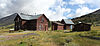 | October 28, 1993 (#93001108) | Boreas Pass Rd. northwest of Como in the Pike National Forest 39°24′40″N 105°58′05″W / 39.4111°N 105.9681°W / 39.4111; -105.9681 (Boreas Railroad Station Site) | Como | |
| 2 | Buckley Ranch |  | January 28, 2000 (#99001667) | County Road 59 39°00′55″N 105°43′48″W / 39.0153°N 105.73°W / 39.0153; -105.73 (Buckley Ranch) | Hartsel | |
| 3 | Colorado Salt Works | Upload image | February 2, 2001 (#01000033) | 3858 U.S. Route 285 38°57′11″N 105°56′43″W / 38.9531°N 105.9453°W / 38.9531; -105.9453 (Colorado Salt Works) | Hartsel | |
| 4 | Como Cemetery | 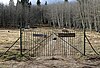 | April 10, 2017 (#100000842) | Cty. Rd. 33 39°19′34″N 105°54′06″W / 39.3261°N 105.9016°W / 39.3261; -105.9016 (Como Cemetery) | Como vicinity | |
| 5 | Como Roundhouse, Railroad Depot and Hotel Complex |  | May 20, 1983 (#83003880) | Off U.S. Route 285 39°19′01″N 105°53′29″W / 39.3169°N 105.8914°W / 39.3169; -105.8914 (Como Roundhouse, Railroad Depot and Hotel Complex) | Como | Renovated Denver, South Park and Pacific Railroad roundhouse in Como, Colorado. |
| 6 | Como School |  | June 30, 2000 (#00000739) | Spruce St. 39°19′01″N 105°53′48″W / 39.3169°N 105.8967°W / 39.3169; -105.8967 (Como School) | Como | Complex including a grade school with belltower built in 1883 |
| 7 | EM Ranch | Upload image | October 15, 2002 (#02001142) | County Road 439 39°04′40″N 105°48′33″W / 39.0778°N 105.8092°W / 39.0778; -105.8092 (EM Ranch) | Hartsel | |
| 8 | Estabrook Historic District | Upload image | October 20, 1980 (#80000919) | Northeast of Bailey 39°22′51″N 105°25′42″W / 39.3808°N 105.4283°W / 39.3808; -105.4283 (Estabrook Historic District) | Bailey | |
| 9 | Fairplay Hotel | 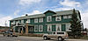 | January 16, 2008 (#07001395) | 500 Main St. 39°13′29″N 106°00′03″W / 39.2247°N 106.0008°W / 39.2247; -106.0008 (Fairplay Hotel) | Fairplay | |
| 10 | Glenisle | 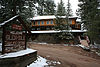 | January 18, 1985 (#85000084) | Off U.S. Route 285 39°24′34″N 105°30′00″W / 39.4094°N 105.5°W / 39.4094; -105.5 (Glenisle) | Bailey | |
| 11 | Guiraud-McDowell Ranch |  | April 12, 2016 (#16000154) | Colorado State Highway 9 39°06′46″N 105°53′26″W / 39.1129°N 105.8906°W / 39.1129; -105.8906 (Guiraud-McDowell Ranch) | Garo | |
| 12 | Jefferson Denver South Park and Pacific Railroad Depot | 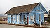 | December 31, 1998 (#98001554) | Junction of U.S. Route 285 and County Road 35 39°22′38″N 105°48′02″W / 39.3772°N 105.8006°W / 39.3772; -105.8006 (Jefferson Denver South Park and Pacific Railroad Depot) | Jefferson | |
| 13 | Paris Mill | 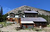 | August 6, 2013 (#13000574) | Address Restricted | Alma | |
| 14 | Park County Courthouse and Jail | 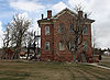 | May 25, 1979 (#79000618) | 418 Main St. 39°13′32″N 106°00′06″W / 39.2256°N 106.0017°W / 39.2256; -106.0017 (Park County Courthouse and Jail) | Fairplay | |
| 15 | Salt Works Ranch | 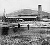 | February 2, 2001 (#01000032) | 3858 U.S. Route 285 38°57′19″N 105°56′59″W / 38.9553°N 105.9497°W / 38.9553; -105.9497 (Salt Works Ranch) | Hartsel | |
| 16 | Shawnee |  | July 8, 2010 (#10000434) | 56016-56114 Frontage Rd.; 55919-56278 U.S. Route 285; 31-36 W. Shawnee Rd.; 54-152 Waterworks Rd. 39°25′16″N 105°53′15″W / 39.4211°N 105.8875°W / 39.4211; -105.8875 (Shawnee) | Shawnee | |
| 17 | South Park City Museum |  | November 5, 2014 (#14000899) | 100 4th St. 39°13′31″N 106°00′16″W / 39.2253°N 106.0044°W / 39.2253; -106.0044 (South Park City Museum) | Fairplay | |
| 18 | South Park Community Church | 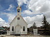 | November 22, 1977 (#77000382) | 6th and Hathaway Sts. 39°13′29″N 105°59′57″W / 39.2247°N 105.9992°W / 39.2247; -105.9992 (South Park Community Church) | Fairplay | |
| 19 | South Park Lager Beer Brewery |  | June 25, 1974 (#74000590) | 3rd and Front Sts. 39°13′32″N 106°00′12″W / 39.2256°N 106.0033°W / 39.2256; -106.0033 (South Park Lager Beer Brewery) | Fairplay | |
| 20 | South Platte River Bridge |  | March 22, 2018 (#100002221) | Cty. Rd. 90a over S. Platte R., mi. marker 40 38°59′11″N 105°21′48″W / 38.9864°N 105.3634°W / 38.9864; -105.3634 (South Platte River Bridge) | Lake George vicinity | |
| 21 | Spring House-Moynahan House | Upload image | March 22, 2021 (#100006292) | 53 South Pine St. 39°16′56″N 106°03′43″W / 39.2823°N 106.0620°W / 39.2823; -106.0620 (Spring House-Moynahan House) | Alma | |
| 22 | Staunton Ranch-Rural Historic Landscape | Upload image | December 4, 2012 (#12000991) | 11559 Upper Ranch Dr. 39°30′17″N 105°23′24″W / 39.5046°N 105.3899°W / 39.5046; -105.3899 (Staunton Ranch-Rural Historic Landscape) | Pine | Extends into Jefferson County |
| 23 | Summer Saloon |  | May 8, 1974 (#74000591) | 3rd and Front Sts. 39°13′29″N 106°00′17″W / 39.2247°N 106.0047°W / 39.2247; -106.0047 (Summer Saloon) | Fairplay | |
| 24 | Tarryall Rural Historic District | Upload image | November 1, 2017 (#100000788) | Cty. Rd. 77, mileposts 2.4 to 33.7 & 34.6 to 41.8 39°20′55″N 105°46′35″W / 39.3485°N 105.7764°W / 39.3485; -105.7764 (Tarryall Rural Historic District) | Jefferson vicinity | |
| 25 | Tarryall School |  | May 16, 1985 (#85001060) | 31000 County Rd. 39°07′14″N 105°28′25″W / 39.1206°N 105.4736°W / 39.1206; -105.4736 (Tarryall School) | Tarryall | |
| 26 | Threemile Gulch | Upload image | September 13, 2011 (#11000632) | Feeding into the Middle Fork South Platte River, 3 miles (4.8 km) north of Hartsel[6] 39°03′42″N 105°47′34″W / 39.0617°N 105.7928°W / 39.0617; -105.7928 (Threemile Gulch) | Hartsel | |
| 27 | Trout Creek-Annex-Settele Ranch | Upload image | April 29, 2008 (#08000345) | 3242 County Road 7 39°07′33″N 105°54′11″W / 39.1258°N 105.9031°W / 39.1258; -105.9031 (Trout Creek-Annex-Settele Ranch) | Fairplay | |
| 28 | Wahl Ranch | 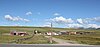 | October 12, 2000 (#00001194) | U.S. Route 285 and Lost Park Rd. 39°23′31″N 105°47′23″W / 39.3919°N 105.7897°W / 39.3919; -105.7897 (Wahl Ranch) | Jefferson | |
| 29 | Victor Williams Homestead-Sprague Sand Creek Ranch | Upload image | February 6, 2024 (#100009925) | 25700 County Road 77 39°12′10″N 105°33′53″W / 39.2029°N 105.5646°W / 39.2029; -105.5646 (Victor Williams Homestead-Sprague Sand Creek Ranch) | Lake George |
See also
 History portal
 United States portal
 Colorado portal
 National Register of Historic Places portal


- List of National Historic Landmarks in Colorado
- List of National Register of Historic Places in Colorado
- Bibliography of Colorado
- Geography of Colorado
- History of Colorado
- Index of Colorado-related articles
- List of Colorado-related lists
- Outline of Colorado
References
- ^ The latitude and longitude information provided in this table was derived originally from the National Register Information System, which has been found to be fairly accurate for about 99% of listings. Some locations in this table may have been corrected to current GPS standards.
- ^ National Park Service, United States Department of the Interior, "National Register of Historic Places: Weekly List Actions", retrieved September 5, 2024.
- ^ Numbers represent an alphabetical ordering by significant words. Various colorings, defined here, differentiate National Historic Landmarks and historic districts from other NRHP buildings, structures, sites or objects.
- ^ "National Register Information System". National Register of Historic Places. National Park Service. July 9, 2010.
- ^ The eight-digit number below each date is the number assigned to each location in the National Register Information System database, which can be viewed by clicking the number.
- ^ Location derived from its GNIS feature record; the NRIS lists the site as "Address Restricted".
External links
Wikimedia Commons has media related to Park County, Colorado.
- State of Colorado
- History Colorado
- Park County, Colorado
| |
|---|---|
| Topics | |
| Lists by state |
|
| Lists by insular areas | |
| Lists by associated state | |
| Other areas | |
| Related | |
| |


Municipalities and communities of Park County, Colorado, United States | ||
|---|---|---|
County seat: Fairplay | ||
| Towns |  | |
| CDPs | ||
| Unincorporated communities | ||
| Ghost towns |
| |
| ||
| |
|---|---|
Denver (capital) | |
| Topics |
|
| Society | |
| Cities |
|
| Counties |
|
| Regions |
|
 Colorado portal Colorado portal | |
39°07′08″N 105°43′02″W / 39.1188°N 105.7171°W / 39.1188; -105.7171 (Park County, Colorado)


