Bacombe and Coombe Hills
| Site of Special Scientific Interest | |
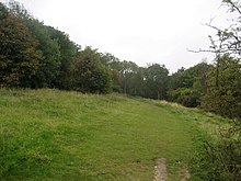 Ridgeway on Bacombe Hill | |
| Location | Buckinghamshire |
|---|---|
| Grid reference | SP852068 |
| Interest | Biological |
| Area | 76.4 hectares |
| Notification | 1999 |
| Location map | Magic Map |
Bacombe and Coombe Hills is a 76.4-hectare (189-acre) biological Site of Special Scientific Interest in Upper Bacombe in Buckinghamshire.[1][2] Bacombe Hill was formerly owned by Buckinghamshire County Council, which transferred it to Berkshire, Buckinghamshire and Oxfordshire Wildlife Trust in 2014.[3][4] Coombe Hill is owned by the National Trust.[5]
The site is in the Chilterns Area of Outstanding Natural Beauty[6] and Bacombe Hill is a Local Nature Reserve.[7][8] The Ridgeway National Trail crosses the site.[6]
The site is chalk grassland which has a rich variety of species. including the entire British population of fringed gentian, and there are areas of juniper and mixed scrub. Invertebrates include scarce species, such as chalkhill blue and brown argus butterflies.[1] Bacombe Hill is noted for orchids.[7]
There is access from Ellesbrough Road.[6]
References
- ^ a b "Bacombe and Coombe Hills citation" (PDF). Sites of Special Scientific Interest. Natural England. Archived from the original (PDF) on 31 December 2014. Retrieved 4 January 2015.
- ^ "Map of Bacombe and Coombe Hills". Sites of Special Scientific Interest. Natural England. Retrieved 4 January 2015.
- ^ "Officer Executive Decision - Divestment of land at Bacombe Hill to Berkshire, Buckinghamshire & Oxfordshire Wildlife Trust" (PDF). Buckinghamshire County Council. 5 October 2014.
- ^ "COMMUNITY WILDLIFE OFFICER (BUCKS)" (PDF). Berkshire, Buckinghamshire & Oxfordshire Wildlife Trust. Archived from the original (PDF) on 29 September 2015. Retrieved 28 September 2015.
- ^ "Chilterns Countryside". National Trust. Retrieved 28 September 2015.
- ^ a b c "Bacombe Hill Local Nature Reserve". Chilterns Conservation Board. Retrieved 4 January 2015.
- ^ a b "Bacombe Hill". Local Nature Reserves. Natural England. 8 August 2013. Archived from the original on 4 January 2015. Retrieved 4 January 2015.
- ^ "Map of Bacombe Hill". Local Nature Reserves. Natural England. Retrieved 4 January 2015.
External links
- "Bacombe Hill". Berkshire, Buckinghamshire and Oxfordshire Wildlife Trust.
- v
- t
- e
- Ashridge Commons and Woods
- Aston Clinton Ragpits
- Aston Rowant
- Aston Rowant Woods
- Bacombe and Coombe Hills
- Black Park
- Bradenham Woods, Park Wood and The Coppice
- Burnham Beeches
- Buttlers Hangings
- Dancersend
- Dancersend Waterworks
- Ellesborough and Kimble Warrens
- Fayland Chalk Bank
- Finemere Wood
- Foxcote Reservoir and Wood
- Frieth Meadows
- Frogmore Meadows
- Gomm Valley
- Grangelands and Pulpit Hill
- Grendon and Doddershall Woods
- Ham Home-cum-Hamgreen Woods
- Hodgemoor Wood
- Hollowhill and Pullingshill Woods
- Homefield Wood
- Howe Park Wood
- Ivinghoe Hills
- Kingcup Meadows and Oldhouse Wood
- Kings and Bakers Woods and Heaths
- Littleworth Common
- Lodge Hill
- Long Herdon Meadow
- Mid Colne Valley
- Millfield Wood
- Moorend Common
- Naphill Common
- Old Rectory Meadows
- Oxley Mead
- Pilch Fields
- Pitstone Hill
- Poker's Pond Meadow
- Rodbed Wood
- Rushbeds Wood and Railway Cutting
- Shabbington Woods Complex
- Sheephouse Wood
- Stoke Common
- Swain's Wood
- Temple Island Meadows
- Tingewick Meadows
- Tring Reservoirs
- Turville Hill
- Weston Turville Reservoir
- Widdenton Park Wood
- Windsor Hill
- Wormsley Chalk Banks
- Yardley Chase
51°45′12″N 0°46′02″W / 51.7534°N 0.7671°W / 51.7534; -0.7671


