Hesperus Mountain (Colorado)
Mountain in Colorado, United States


Hesperus Mountain
Colorado
La Plata Mountains[2]
La Plata, Colorado[3]
Hesperus Mountain (Navajo: Dibé Ntsaa meaning "Big Mountain Sheep"[4]) is the highest summit of the La Plata Mountains range of the Rocky Mountains of North America. The prominent 13,237-foot (4,035 m) thirteener is located in San Juan National Forest, 13.2 miles (21.2 km) northeast by east (bearing 59°) of the Town of Mancos in Montezuma County, Colorado, United States. The summit of Hesperus Mountain is the highest point in Montezuma County.[1][2][3]
Mountain
Though not of particularly high elevation for the region, Hesperus Mountain is visually quite prominent, as it is near the southern edge of the San Juan Mountains and rises over 7,000 ft (2,100 m) above the area.
Hesperus is notable as the Navajo People's Sacred Mountain of the North, Dibé Ntsaa, which marks the northern boundary of the Dinetah, their traditional homeland. It is associated with the color black, and is said to be impregnated with jet. When First Man created the mountain as a replica of mountains in the Fourth World, he fastened it to the ground with a rainbow and covered it in darkness.[5]
The San Juan Mountains have been the traditional homeland of the Ute People. http://www.dargnet.org http://uintahbasintah.org/maps/ubsw.jpg
Along with Ute the La Plata Mountain Range has also been the early homeland of the Navajo People who had settled on and near this mountain and the La Plata Mountain Range.
Gallery
-
 Aerial view of the mountain
 -
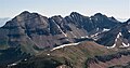
 Hesperus seen from Centennial Peak
 -
 Aerial from west: Hesperus, Lavender, Moss
 -
 Hesperus Mountain (left) and Mount Moss (center) from the west at sunset
 -
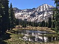 Hesperus Mountain in Spring


See also
- List of mountain peaks of Colorado
- List of Colorado county high points
- San Juan Mountains (Colorado)
References
- ^ a b The elevation of Hesperus Mountain includes an adjustment of +1.650 m (+5.41 ft) from NGVD 29 to NAVD 88.
- ^ a b c d e f "Hesperus Mountain, Colorado". Peakbagger.com. Retrieved October 20, 2014.
- ^ a b c "Hesperus Mountain". Geographic Names Information System. United States Geological Survey, United States Department of the Interior. Retrieved October 20, 2014.
- ^ Carey, Harold. "Mount Hesperus – Navajo Sacred Mountain". Navajo People.
- ^ Robert S. McPherson, Sacred Land, Sacred View: Navajo perceptions of the Four Corners Region, Brigham Young University, ISBN 1-56085-008-6.
External links
Hesperus Mountain at Wikipedia's sister projects
 Definitions from Wiktionary
 Media from Commons
 News from Wikinews
 Quotations from Wikiquote
 Texts from Wikisource
 Textbooks from Wikibooks
 Resources from Wikiversity
- Hesperus Mountain on Hikearizona.com
- v
- t
- e

- Mount Garfield
- Aspen Mountain
- Capitol Peak
- Castle Peak
- Cathedral Peak
- Chair Mountain
- Crested Butte
- Gothic Mountain
- Italian Mountain
- Maroon Bells
- Mount Emmons
- Mount Owen
- Mount Sopris
- Pyramid Peak
- Snowmass Mountain
- Snowmass Peak
- Treasure Mountain
- Black Mountain (Moffat County)
- Columbus Mountain
- Elk Mountain (Routt County)
- Hahns Peak
- Flat Top Mountain
- Sleepy Cat Peak
- Eagles Nest
- Jacque Peak
- Meridian Peak
- Mount Powell
- The Spider
- Crater Peak
- North Mamm Peak
- Clark Peak
- Arkansas Hills
- Clinton Peak
- Dyer Mountain
- Gemini Peak
- Horseshoe Mountain
- Mount Arkansas
- Mount Bross
- Mount Buckskin
- Mount Democrat
- Mount Lincoln
- Mount Sheridan
- Mount Sherman
- Pacific Peak
- West Buffalo Peak
- Elk Mountain (Grand County)
- Parkview Mountain
- Radial Mountain
- Whiteley Peak
| Sangre de Cristo Range |
|
|---|---|
| Wet Mountains |
|
| Others |
|
| Collegiate Peaks |
|
|---|---|
| Others |
|
- Crystal Peak
- Fletcher Mountain
- Peak 10
- Peak One
- Quandary Peak
- Tenmile Peak
- Bear Mountain
- Blair Mountain
- Chalk Mountains
- Cochetopa Hills
- Dawson Butte
- Diamond Peak
- Flirtation Peak
- Granite Peak
- Grand Hogback
- Grannys Nipple
- Horsefly Peak
- Lead Mountain (Grand County)
- Mount Neva
- Powell Peak
- San Luis Hills
- Storm King Mountain
- Terrible Mountain
- Two Buttes
- Ute Mountain
| |
|---|---|
|


