National Register of Historic Places listings in Brooke County, West Virginia
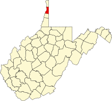
This is a list of the National Register of Historic Places listings in Brooke County, West Virginia.
This is intended to be a comprehensive list of the properties and districts on the National Register of Historic Places in Brooke County, West Virginia, United States. The locations of National Register properties and districts for which the latitude and longitude coordinates are included below may be viewed on Google maps.[1]
There are 24 properties and districts listed on the National Register in the county, 2 of which are National Historic Landmarks.
This National Park Service list is complete through NPS recent listings posted August 16, 2024.[2]
Map all coordinates using OpenStreetMap
Download coordinates as:
- KML
- GPX (all coordinates)
- GPX (primary coordinates)
- GPX (secondary coordinates)
Barbour - Berkeley - Boone - Braxton - Brooke - Cabell - Calhoun - Clay - Doddridge - Fayette - Gilmer - Grant - Greenbrier - Hampshire - Hancock - Hardy - Harrison - Jackson - Jefferson - Kanawha - Lewis - Lincoln - Logan - Marion - Marshall - Mason - McDowell - Mercer - Mineral - Mingo - Monongalia - Monroe - Morgan - Nicholas - Ohio - Pendleton - Pleasants - Pocahontas - Preston - Putnam - Raleigh - Randolph - Ritchie - Roane - Summers - Taylor - Tucker - Tyler - Upshur - Wayne - Webster - Wetzel - Wirt - Wood - Wyoming |
Current listings
| [3] | Name on the Register[4] | Image | Date listed[5] | Location | City or town | Description |
|---|---|---|---|---|---|---|
| 1 | Beallmore |  | May 16, 1986 (#86001069) | 1500 Pleasant Ave. 40°16′42″N 80°36′24″W / 40.278333°N 80.606667°W / 40.278333; -80.606667 (Beallmore) | Wellsburg | |
| 2 | Bethany Historic District |  | April 1, 1982 (#82004311) | West Virginia Route 67 40°12′22″N 80°33′16″W / 40.206111°N 80.554444°W / 40.206111; -80.554444 (Bethany Historic District) | Bethany | |
| 3 | Brooke Cemetery |  | May 16, 1986 (#86001070) | 2200 Pleasant Ave. 40°17′15″N 80°36′17″W / 40.2875°N 80.604722°W / 40.2875; -80.604722 (Brooke Cemetery) | Wellsburg | |
| 4 | Danforth Brown House |  | October 29, 1992 (#92001484) | 555 Washington Pike (West Virginia Route 27) 40°16′06″N 80°35′26″W / 40.268333°N 80.590556°W / 40.268333; -80.590556 (Danforth Brown House) | Wellsburg | |
| 5 | Alexander Campbell Mansion | 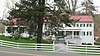 | October 15, 1970 (#70000651) | East of Bethany on West Virginia Route 67 40°12′27″N 80°32′51″W / 40.2075°N 80.5475°W / 40.2075; -80.5475 (Alexander Campbell Mansion) | Bethany | |
| 6 | Delta Tau Delta Founders House | 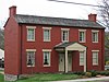 | May 29, 1979 (#79002571) | 211 Main St. 40°12′19″N 80°33′27″W / 40.205278°N 80.5575°W / 40.205278; -80.5575 (Delta Tau Delta Founders House) | Bethany | |
| 7 | Gen. I.H. Duval Mansion |  | May 16, 1986 (#86001071) | 1222 Pleasant Ave. 40°16′27″N 80°36′27″W / 40.274167°N 80.6075°W / 40.274167; -80.6075 (Gen. I.H. Duval Mansion) | Wellsburg | |
| 8 | Elmhurst |  | May 16, 1986 (#86001072) | 1606 Pleasant Ave. 40°16′47″N 80°36′22″W / 40.279722°N 80.606111°W / 40.279722; -80.606111 (Elmhurst) | Wellsburg | |
| 9 | David and Lucy Tarr Fleming Mansion |  | May 16, 1986 (#86001073) | 2000 Pleasant Ave. 40°16′55″N 80°36′20″W / 40.281944°N 80.605556°W / 40.281944; -80.605556 (David and Lucy Tarr Fleming Mansion) | Wellsburg | |
| 10 | Lewis Hall Mansion |  | May 16, 1986 (#86001074) | 1300 Pleasant Ave. 40°16′31″N 80°36′27″W / 40.275278°N 80.6075°W / 40.275278; -80.6075 (Lewis Hall Mansion) | Wellsburg | |
| 11 | Inn at Fowlerstown |  | October 29, 1992 (#92001483) | 1001 Washington Pike (West Virginia Route 27) 40°16′47″N 80°33′18″W / 40.279722°N 80.555°W / 40.279722; -80.555 (Inn at Fowlerstown) | Wellsburg | |
| 12 | Kirker House |  | September 15, 1986 (#86002883) | 1520 Grand Ave. 40°16′43″N 80°36′20″W / 40.278611°N 80.605556°W / 40.278611; -80.605556 (Kirker House) | Wellsburg | |
| 13 | Market Street Bridge |  | March 21, 2019 (#100003517) | West Virginia Route 2 spur and Market Street 40°21′28″N 80°36′28″W / 40.357778°N 80.607778°W / 40.357778; -80.607778 (Market Street Bridge) | East Steubenville | Extends into Jefferson County, Ohio |
| 14 | Miller's Tavern |  | December 14, 1978 (#78002790) | 6th and Main Sts. 40°16′09″N 80°36′50″W / 40.269167°N 80.613889°W / 40.269167; -80.613889 (Miller's Tavern) | Wellsburg | |
| 15 | Nicholls House and Woolen Mill Site |  | November 13, 1997 (#97001416) | West Virginia Route 67, Wellsburg-Bethany Pike, overlooking Buffalo Creek 40°15′27″N 80°36′03″W / 40.2575°N 80.600833°W / 40.2575; -80.600833 (Nicholls House and Woolen Mill Site) | Wellsburg | |
| 16 | Old Bethany Church | 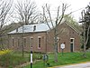 | December 12, 1976 (#76001932) | Main and Church Sts. 40°12′23″N 80°33′15″W / 40.206389°N 80.554167°W / 40.206389; -80.554167 (Old Bethany Church) | Bethany | |
| 17 | Old Main, Bethany College |  | August 25, 1970 (#70000652) | Bethany College campus 40°12′21″N 80°33′37″W / 40.205833°N 80.560278°W / 40.205833; -80.560278 (Old Main, Bethany College) | Bethany | |
| 18 | Harry and Louisiana Beall Paull Mansion |  | May 16, 1986 (#86001075) | 1312 Pleasant Ave. 40°16′29″N 80°36′23″W / 40.274722°N 80.606389°W / 40.274722; -80.606389 (Harry and Louisiana Beall Paull Mansion) | Wellsburg | |
| 19 | Pendleton Heights |  | June 26, 1975 (#75001882) | Bethany College campus 40°12′24″N 80°33′35″W / 40.206667°N 80.559722°W / 40.206667; -80.559722 (Pendleton Heights) | Bethany | |
| 20 | John C. Reeves House |  | September 28, 2006 (#06000903) | 100 Reeves Dr. 40°17′36″N 80°33′51″W / 40.293333°N 80.564167°W / 40.293333; -80.564167 (John C. Reeves House) | Wellsburg | |
| 21 | Lucy Tarr Mansion |  | May 16, 1986 (#86001076) | 1456 Pleasant Ave. 40°16′40″N 80°36′24″W / 40.277778°N 80.606667°W / 40.277778; -80.606667 (Lucy Tarr Mansion) | Wellsburg | |
| 22 | Vancroft |  | September 15, 1986 (#86002885) | Brinker Rd. 40°17′07″N 80°35′51″W / 40.285278°N 80.5975°W / 40.285278; -80.5975 (Vancroft) | Wellsburg | |
| 23 | Wellsburg Historic District |  | April 1, 1982 (#82004312) | West Virginia Route 2 40°16′43″N 80°36′42″W / 40.278611°N 80.611667°W / 40.278611; -80.611667 (Wellsburg Historic District) | Wellsburg | |
| 24 | Wellsburg Wharf |  | November 27, 1979 (#79002572) | 6th and Main Sts. 40°16′09″N 80°36′52″W / 40.269167°N 80.614444°W / 40.269167; -80.614444 (Wellsburg Wharf) | Wellsburg |
See also
Wikimedia Commons has media related to National Register of Historic Places in Brooke County, West Virginia.
- List of National Historic Landmarks in West Virginia
- National Register of Historic Places listings in West Virginia
References
- ^ The latitude and longitude information provided in this table was derived originally from the National Register Information System, which has been found to be fairly accurate for about 99% of listings. Some locations in this table may have been corrected to current GPS standards.
- ^ National Park Service, United States Department of the Interior, "National Register of Historic Places: Weekly List Actions", retrieved August 16, 2024.
- ^ Numbers represent an alphabetical ordering by significant words. Various colorings, defined here, differentiate National Historic Landmarks and historic districts from other NRHP buildings, structures, sites or objects.
- ^ "National Register Information System". National Register of Historic Places. National Park Service. April 24, 2008.
- ^ The eight-digit number below each date is the number assigned to each location in the National Register Information System database, which can be viewed by clicking the number.
- v
- t
- e

county
- Barbour
- Berkeley
- Boone
- Braxton
- Brooke
- Cabell
- Calhoun
- Clay
- Doddridge
- Fayette
- Gilmer
- Grant
- Greenbrier
- Hampshire
- Hancock
- Hardy
- Harrison
- Jackson
- Jefferson
- Kanawha
- Lewis
- Lincoln
- Logan
- Marion
- Marshall
- Mason
- McDowell
- Mercer
- Mineral
- Mingo
- Monongalia
- Monroe
- Morgan
- Nicholas
- Ohio
- Pendleton
- Pleasants
- Pocahontas
- Preston
- Putnam
- Raleigh
- Randolph
- Ritchie
- Roane
- Summers
- Taylor
- Tucker
- Tyler
- Upshur
- Wayne
- Webster
- Wetzel
- Wirt
- Wood
- Wyoming
 Category:National Register of Historic Places in West Virginia
 Portal:National Register of Historic Places


Municipalities and communities of Brooke County, West Virginia, United States | ||
|---|---|---|
County seat: Wellsburg | ||
| Cities |  | |
| Town | ||
| Villages | ||
| CDPs | ||
| Other communities | ||
| Footnotes | ‡This populated place also has portions in an adjacent county or counties | |
| ||


