National Register of Historic Places listings in Jefferson County, West Virginia
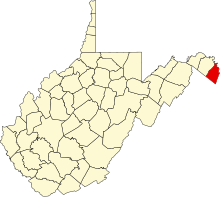
This is a list of the National Register of Historic Places listings in Jefferson County, West Virginia.
This is intended to be a complete list of the properties and districts on the National Register of Historic Places in Jefferson County, West Virginia, United States. The locations of National Register properties and districts for which the latitude and longitude coordinates are included below, may be seen in an online map.[1]
There are 86 properties and districts listed on the National Register in the county, 2 of which are National Historic Landmarks.
This National Park Service list is complete through NPS recent listings posted August 16, 2024.[2]
Map all coordinates using OpenStreetMap
Download coordinates as:
- KML
- GPX (all coordinates)
- GPX (primary coordinates)
- GPX (secondary coordinates)
Barbour - Berkeley - Boone - Braxton - Brooke - Cabell - Calhoun - Clay - Doddridge - Fayette - Gilmer - Grant - Greenbrier - Hampshire - Hancock - Hardy - Harrison - Jackson - Jefferson - Kanawha - Lewis - Lincoln - Logan - Marion - Marshall - Mason - McDowell - Mercer - Mineral - Mingo - Monongalia - Monroe - Morgan - Nicholas - Ohio - Pendleton - Pleasants - Pocahontas - Preston - Putnam - Raleigh - Randolph - Ritchie - Roane - Summers - Taylor - Tucker - Tyler - Upshur - Wayne - Webster - Wetzel - Wirt - Wood - Wyoming |
Current listings
| [3] | Name on the Register | Image | Date listed[4] | Location | City or town | Description |
|---|---|---|---|---|---|---|
| 1 | Christian Allemong House |  | May 2, 2003 (#03000346) | 35 Hardestry Rd. 39°14′14″N 77°58′43″W / 39.237222°N 77.978611°W / 39.237222; -77.978611 (Christian Allemong House) | Summit Point | |
| 2 | Allstadt House and Ordinary |  | April 9, 1985 (#85000767) | Junction of U.S. Route 340 and County Road 27 39°18′59″N 77°45′20″W / 39.31626°N 77.75568°W / 39.31626; -77.75568 (Allstadt House and Ordinary) | Harpers Ferry | |
| 3 | Altona |  | November 24, 1995 (#95001322) | WV 51 west of Charles Town 39°17′24″N 77°52′57″W / 39.29°N 77.8825°W / 39.29; -77.8825 (Altona) | Charles Town | |
| 4 | Aspen Hill | Upload image | March 13, 1980 (#80004024) | North of Charles Town on WV 9 39°19′18″N 77°51′44″W / 39.321667°N 77.862222°W / 39.321667; -77.862222 (Aspen Hill) | Charles Town | |
| 5 | B & O Railroad Potomac River Crossing |  | February 14, 1978 (#78001484) | At the confluence of the Shenandoah and Potomac Rivers 39°19′27″N 77°43′43″W / 39.324167°N 77.728611°W / 39.324167; -77.728611 (B & O Railroad Potomac River Crossing) | Harpers Ferry | |
| 6 | Barleywood | Upload image | May 24, 2007 (#07000241) | Ambler Rd., approximately 1 mi (1.6 km) north of WV 51 39°18′54″N 77°54′42″W / 39.314883°N 77.911792°W / 39.314883; -77.911792 (Barleywood) | Charles Town | |
| 7 | Beall-Air |  | August 17, 1973 (#73001914) | West of Halltown off U.S. Route 340 39°18′55″N 77°48′44″W / 39.315278°N 77.812222°W / 39.315278; -77.812222 (Beall-Air) | Halltown | |
| 8 | Belvedere | Upload image | January 12, 1984 (#84003588) | 76 Belvedere Farm Dr. 39°17′05″N 77°50′43″W / 39.284722°N 77.845278°W / 39.284722; -77.845278 (Belvedere) | Charles Town | |
| 9 | Beverley | 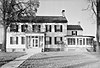 | March 20, 1987 (#87000486) | U.S. Route 340; also 1 Burns Farm Rd. 39°15′03″N 77°53′34″W / 39.250833°N 77.892778°W / 39.250833; -77.892778 (Beverley) | Charles Town | Burns Farm represents a boundary increase of April 12, 2010 |
| 10 | Blakeley |  | April 15, 1982 (#82004319) | Huyett Road 39°15′36″N 77°54′22″W / 39.26°N 77.906111°W / 39.26; -77.906111 (Blakeley) | Charles Town | |
| 11 | Boidstones Place | Upload image | November 22, 1999 (#99001397) | Shepherd Grade 39°28′11″N 77°48′06″W / 39.469722°N 77.801667°W / 39.469722; -77.801667 (Boidstones Place) | Shepherdstown | |
| 12 | The Bower | 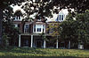 | April 15, 1982 (#82004321) | County Road 1/1 39°21′54″N 77°57′27″W / 39.365°N 77.9575°W / 39.365; -77.9575 (The Bower) | Leetown | |
| 13 | Peter Burr House |  | April 9, 1982 (#82004322) | Warm Springs Rd. 39°21′34″N 77°51′25″W / 39.359444°N 77.856944°W / 39.359444; -77.856944 (Peter Burr House) | Shenandoah Junction | |
| 14 | Cedar Lawn | 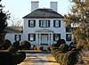 | December 4, 1974 (#74002004) | 3.5 mi (5.6 km) west of Charles Town off Virginia State Route 51 and south on County Road 51/1 39°17′06″N 77°55′22″W / 39.285°N 77.922778°W / 39.285; -77.922778 (Cedar Lawn) | Charles Town | |
| 15 | Charles Town Mining, Manufacturing, and Improvement Company Building |  | August 2, 2001 (#01000779) | 312 S. Mildred St. 39°17′40″N 77°51′38″W / 39.294444°N 77.860556°W / 39.294444; -77.860556 (Charles Town Mining, Manufacturing, and Improvement Company Building) | Ranson | |
| 16 | Claymont Court |  | July 25, 1973 (#73001908) | Southwest of Charles Town off U.S. Route 340 39°16′07″N 77°54′21″W / 39.268611°N 77.905833°W / 39.268611; -77.905833 (Claymont Court) | Charles Town | |
| 17 | Cold Spring |  | August 14, 1973 (#73001917) | South of Shepherdstown on County Road 17 39°23′48″N 77°49′05″W / 39.396667°N 77.818056°W / 39.396667; -77.818056 (Cold Spring) | Shepherdstown | |
| 18 | Cool Spring Farm |  | March 27, 2007 (#07000239) | 1735 Lloyd Rd. 39°14′44″N 77°55′55″W / 39.24556°N 77.93194°W / 39.24556; -77.93194 (Cool Spring Farm) | Charles Town | |
| 19 | Downtown Charles Town Historic District |  | March 21, 1997 (#97000263) | Roughly Washington, Liberty, and Congress Sts. from the eastern town limits to Water St. 39°17′21″N 77°51′33″W / 39.289167°N 77.859167°W / 39.289167; -77.859167 (Downtown Charles Town Historic District) | Charles Town | |
| 20 | Duffields Depot | 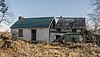 | August 3, 2007 (#07000780) | 45 Melvin Rd. 39°21′46″N 77°49′32″W / 39.36282°N 77.82568°W / 39.36282; -77.82568 (Duffields Depot) | Shenandoah Junction | |
| 21 | Elmwood |  | August 17, 1973 (#73001918) | South of Shepherdstown off County Road 17 39°23′50″N 77°48′50″W / 39.397222°N 77.813889°W / 39.397222; -77.813889 (Elmwood) | Shepherdstown | |
| 22 | Elmwood-on-the-Opequon | Upload image | March 22, 2006 (#06000165) | 3898 Sulphur Springs Rd. 39°21′13″N 77°57′43″W / 39.353611°N 77.961944°W / 39.353611; -77.961944 (Elmwood-on-the-Opequon) | Kearneysville | |
| 23 | Falling Spring-Morgan's Grove |  | February 15, 1989 (#88002670) | WV 480 39°25′15″N 77°48′55″W / 39.420833°N 77.815278°W / 39.420833; -77.815278 (Falling Spring-Morgan's Grove) | Shepherdstown | |
| 24 | Feagans' Mill Complex | Upload image | January 23, 2017 (#100000572) | 28 Feagans' Mill Ln. 39°14′31″N 77°55′19″W / 39.241893°N 77.921822°W / 39.241893; -77.921822 (Feagans' Mill Complex) | Charles Town | |
| 25 | Fruit Hill | Upload image | September 26, 1988 (#88001588) | Shepherd Grade 39°26′53″N 77°49′28″W / 39.448056°N 77.824444°W / 39.448056; -77.824444 (Fruit Hill) | Shepherdstown | |
| 26 | Gap View Farm |  | January 9, 1997 (#96001574) | WV 9, between Charles Town and Shenandoah Junction 39°20′32″N 77°50′58″W / 39.342222°N 77.849444°W / 39.342222; -77.849444 (Gap View Farm) | Charles Town | |
| 27 | Gibson-Todd House |  | September 1, 1983 (#83003238) | 515 S. Samuel St. 39°17′07″N 77°51′21″W / 39.28534°N 77.85592°W / 39.28534; -77.85592 (Gibson-Todd House) | Charles Town | |
| 28 | Glenburnie | Upload image | November 29, 1988 (#88002668) | County Road 16/Ridge Rd. 39°23′27″N 77°50′42″W / 39.390833°N 77.845°W / 39.390833; -77.845 (Glenburnie) | Shenandoah Junction | |
| 29 | William Grubb Farm |  | November 21, 1991 (#91001735) | County Road 340/2, west of its junction with U.S. Route 340 39°14′20″N 77°54′14″W / 39.238889°N 77.903889°W / 39.238889; -77.903889 (William Grubb Farm) | Charles Town | |
| 30 | Nathan Haines Farm | Upload image | October 14, 2022 (#100008071) | 1642 & 1673 Lloyd Rd. 39°14′38″N 77°55′35″W / 39.2440°N 77.9263°W / 39.2440; -77.9263 (Nathan Haines Farm) | Charles Town | Boundary increase approved July 10, 2023. |
| 31 | Halltown Colored Free School |  | August 25, 2004 (#04000912) | Halltown Rd., near the intersection with Tabb Ln. 39°18′44″N 77°48′06″W / 39.312222°N 77.801667°W / 39.312222; -77.801667 (Halltown Colored Free School) | Halltown | |
| 32 | Halltown Union Colored Sunday School |  | January 12, 1984 (#84003591) | Halltown Rd. near the intersection with Tabb Ln. 39°18′34″N 77°48′11″W / 39.309444°N 77.803056°W / 39.309444; -77.803056 (Halltown Union Colored Sunday School) | Halltown | |
| 33 | Harewood |  | March 14, 1973 (#73001909) | West of Charles Town off WV 51 39°18′09″N 77°55′11″W / 39.3025°N 77.919722°W / 39.3025; -77.919722 (Harewood) | Charles Town | |
| 34 | Harpers Ferry Historic District | 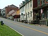 | October 15, 1979 (#79002584) | Off U.S. Route 340 39°19′35″N 77°44′29″W / 39.326389°N 77.741389°W / 39.326389; -77.741389 (Harpers Ferry Historic District) | Harpers Ferry | |
| 35 | Harpers Ferry National Historical Park |  | October 15, 1966 (#66000041) | At confluence of the Shenandoah and Potomac rivers 39°18′59″N 77°43′09″W / 39.316389°N 77.719167°W / 39.316389; -77.719167 (Harpers Ferry National Historical Park) | Harpers Ferry | Boundary increase listed May 10, 2016 |
| 36 | Hazelfield |  | December 12, 1976 (#76001938) | Off County Road 48/2 39°22′25″N 77°51′36″W / 39.373611°N 77.86°W / 39.373611; -77.86 (Hazelfield) | Shenandoah Junction | |
| 37 | The Hermitage |  | December 23, 1993 (#93001444) | Kabletown Rd. (County Road 25) north of its junction with Mt. Hammond Rd. 39°14′53″N 77°50′30″W / 39.248056°N 77.841667°W / 39.248056; -77.841667 (The Hermitage) | Charles Town | Home to R. Preston Chew |
| 38 | Hillside |  | December 12, 1985 (#85003521) | Old Cave Rd. 39°15′47″N 77°52′05″W / 39.263056°N 77.868056°W / 39.263056; -77.868056 (Hillside) | Charles Town | |
| 39 | Hopewell | Upload image | March 25, 1994 (#94000214) | Bloomery Rd. (County Road 27) northeast of Bloomery 39°16′04″N 77°47′36″W / 39.267778°N 77.793333°W / 39.267778; -77.793333 (Hopewell) | Charles Town | |
| 40 | Jacks-Manning Farm |  | January 12, 1984 (#84003594) | U.S. Route 340 39°16′08″N 77°51′38″W / 39.268889°N 77.860556°W / 39.268889; -77.860556 (Jacks-Manning Farm) | Charles Town | |
| 41 | Jefferson County Alms House | Upload image | April 14, 1995 (#95000418) | West Virginia Secondary Route 15 southeast of Leetown 39°20′07″N 77°54′30″W / 39.3353°N 77.9083°W / 39.3353; -77.9083 (Jefferson County Alms House) | Leetown | |
| 42 | Jefferson County Courthouse | 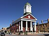 | July 10, 1973 (#73001910) | N. George and E. Washington Sts. 39°17′21″N 77°51′37″W / 39.2892°N 77.8603°W / 39.2892; -77.8603 (Jefferson County Courthouse) | Charles Town | Designated a National Historic Landmark in 2023. |
| 43 | Lee-Longsworth House |  | September 23, 1985 (#85002471) | 1141 Washington St. 39°19′32″N 77°44′49″W / 39.3256°N 77.7469°W / 39.3256; -77.7469 (Lee-Longsworth House) | Harpers Ferry | |
| 44 | Captain William Lucas and Robert Lucas House | | September 2, 1982 (#82004323) | Engle Molers Road 39°24′06″N 77°46′27″W / 39.4017°N 77.7742°W / 39.4017; -77.7742 (Captain William Lucas and Robert Lucas House) | Shepherdstown | |
| 45 | James Marshall House | Upload image | September 27, 1988 (#88001596) | Shepherd Grade 39°27′15″N 77°49′31″W / 39.4542°N 77.8253°W / 39.4542; -77.8253 (James Marshall House) | Shepherdstown | |
| 46 | Media Farm | Upload image | November 10, 1994 (#93000616) | Flowing Springs Rd. (County Road 17), 2 mi (3.2 km) north of Charles Town 39°19′46″N 77°50′32″W / 39.3294°N 77.8422°W / 39.3294; -77.8422 (Media Farm) | Charles Town | |
| 47 | Middleway Historic District | 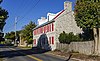 | March 13, 1980 (#80004025) | Leetown Road 39°18′13″N 77°58′58″W / 39.3036°N 77.9828°W / 39.3036; -77.9828 (Middleway Historic District) | Middleway | |
| 48 | Morgan's Grove |  | March 19, 1999 (#99000286) | Roughly bounded by West Virginia Routes 230 and 480, and Morgan's Grove Rd. 39°25′04″N 77°48′45″W / 39.4178°N 77.8125°W / 39.4178; -77.8125 (Morgan's Grove) | Shepherdstown | |
| 49 | Morgan-Bedinger-Dandridge House | 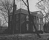 | May 13, 1983 (#83003239) | Southwest of Shepherdstown on WV 480 39°25′37″N 77°48′43″W / 39.4269°N 77.8119°W / 39.4269; -77.8119 (Morgan-Bedinger-Dandridge House) | Shepherdstown | |
| 50 | New Opera House |  | November 24, 1978 (#78002798) | 200-204 N. George St. 39°17′23″N 77°51′39″W / 39.2897°N 77.8608°W / 39.2897; -77.8608 (New Opera House) | Charles Town | |
| 51 | Old Charles Town Historic District | Upload image | November 2, 2000 (#00001308) | Norfolk & Western railroad line, Charles Town line, Hessey Pl., North St., U.S. Route 340, S. Charles St., Water St., and W. Washington St 39°17′14″N 77°51′43″W / 39.2872°N 77.8619°W / 39.2872; -77.8619 (Old Charles Town Historic District) | Charles Town | |
| 52 | James Osbourn Farm | Upload image | April 4, 2023 (#100008820) | 1901 Trough Rd. 39°25′12″N 77°47′08″W / 39.4199°N 77.7856°W / 39.4199; -77.7856 (James Osbourn Farm) | Shepherdstown vicinity | |
| 53 | Potomac Mills |  | February 5, 2014 (#13001166) | River & Trough Rds. 39°25′42″N 77°46′48″W / 39.4282°N 77.7800°W / 39.4282; -77.7800 (Potomac Mills) | Shepherdstown | |
| 54 | Prato Rio | 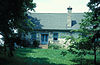 | April 11, 1973 (#73001916) | WV 480 39°20′49″N 77°56′12″W / 39.3469°N 77.9367°W / 39.3469; -77.9367 (Prato Rio) | Leetown | |
| 55 | Rees-Daniel Farm | Upload image | March 28, 2024 (#100010180) | 330 Hidden Hollow Drive 39°19′39″N 77°59′08″W / 39.3274°N 77.9855°W / 39.3274; -77.9855 (Rees-Daniel Farm) | Kearneysville vicinity | |
| 56 | Rellim Farm | Upload image | December 4, 1998 (#98001467) | Leetown Rd., south of WV 9 39°22′51″N 77°53′15″W / 39.3808°N 77.8875°W / 39.3808; -77.8875 (Rellim Farm) | Kearneysville | |
| 57 | Richwood Hall | 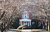 | June 19, 1973 (#73001911) | About 4 mi (6.4 km) west of Charles Town off WV 51 39°17′32″N 77°55′51″W / 39.2922°N 77.9308°W / 39.2922; -77.9308 (Richwood Hall) | Charles Town | |
| 58 | Rion Hall |  | September 20, 1982 (#82004320) | East of Charles Town off U.S. Route 340 39°18′05″N 77°48′19″W / 39.3015°N 77.8054°W / 39.3015; -77.8054 (Rion Hall) | Charles Town | |
| 59 | Ripon Lodge | Upload image | August 31, 1998 (#98001074) | Junction of U.S. Route 340 and Withers-Carve Rd. 39°13′21″N 77°54′30″W / 39.2225°N 77.9083°W / 39.2225; -77.9083 (Ripon Lodge) | Rippon | |
| 60 | Rock Spring |  | January 17, 2008 (#07001416) | 2000 Ridge Rd. 39°23′02″N 77°50′38″W / 39.3840°N 77.8438°W / 39.3840; -77.8438 (Rock Spring) | Shepherdstown | |
| 61 | Rockland | Upload image | February 5, 1990 (#89002316) | WV 480 39°24′30″N 77°51′29″W / 39.4083°N 77.8581°W / 39.4083; -77.8581 (Rockland) | Shepherdstown | |
| 62 | The Rocks | Upload image | December 3, 2020 (#100005843) | 1003 Westside Ln. 39°11′09″N 77°51′11″W / 39.1857°N 77.8530°W / 39.1857; -77.8530 (The Rocks) | Charles Town | |
| 63 | Rose Hill Farm |  | May 18, 1990 (#90000716) | Off WV 480 southeast of its junction with Warm Springs Rd. 39°23′48″N 77°51′45″W / 39.3967°N 77.8625°W / 39.3967; -77.8625 (Rose Hill Farm) | Shepherdstown | |
| 64 | Frederick Rosenberger Farm | Upload image | March 28, 2024 (#100010181) | 494 Harry Shirley Road 39°19′58″N 77°58′12″W / 39.3328°N 77.9701°W / 39.3328; -77.9701 (Frederick Rosenberger Farm) | Kearneysville vicinity | |
| 65 | Rumsey Hall |  | March 30, 1973 (#73001919) | German and Princess Sts. 39°25′57″N 77°48′13″W / 39.4325°N 77.8036°W / 39.4325; -77.8036 (Rumsey Hall) | Shepherdstown | |
| 66 | St. Peter's Roman Catholic Church |  | March 30, 1973 (#73001915) | Church St. and Jefferson Rock Trail 39°19′28″N 77°43′53″W / 39.324444°N 77.731389°W / 39.324444; -77.731389 (St. Peter's Roman Catholic Church) | Harpers Ferry | |
| 67 | Shannondale Springs | Upload image | March 31, 1998 (#98000289) | Off Mission Rd., south of WV 115 39°13′13″N 77°48′58″W / 39.220278°N 77.816111°W / 39.220278; -77.816111 (Shannondale Springs) | Shannondale | |
| 68 | Shepherd's Mill |  | May 6, 1971 (#71000882) | High St. 39°26′00″N 77°48′05″W / 39.433333°N 77.801389°W / 39.433333; -77.801389 (Shepherd's Mill) | Shepherdstown | |
| 69 | Shepherdstown Historic District |  | August 17, 1973 (#73001920) | Bounded roughly by Mill, Rocky, Duke, and Washington Sts. 39°25′58″N 77°48′24″W / 39.432778°N 77.806667°W / 39.432778; -77.806667 (Shepherdstown Historic District) | Shepherdstown | |
| 70 | South Charles Town Historic District |  | September 16, 2009 (#09000733) | S. George, S. Mildred, S. Samuel, & S. Church Sts. 39°16′41″N 77°51′09″W / 39.278014°N 77.852486°W / 39.278014; -77.852486 (South Charles Town Historic District) | Charles Town | |
| 71 | Spring Grove | Upload image | May 17, 2021 (#100006504) | 2497 Smith Rd. 39°12′09″N 77°54′48″W / 39.2024°N 77.9132°W / 39.2024; -77.9132 (Spring Grove) | Charles Town vicinity | |
| 72 | Strider Farm | 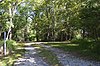 | February 1, 1988 (#87002524) | Bakerton Road 39°20′03″N 77°45′55″W / 39.334167°N 77.765278°W / 39.334167; -77.765278 (Strider Farm) | Harpers Ferry | |
| 73 | Sunnyside Farm | Upload image | March 18, 1999 (#99000285) | Leetown Rd. 39°19′53″N 77°57′31″W / 39.3314°N 77.958683°W / 39.3314; -77.958683 (Sunnyside Farm) | Kearneysville | |
| 74 | Tackley Farm |  | November 4, 1994 (#94001286) | WV 9 2 mi (3.2 km) east of its junction with WV 480 39°21′50″N 77°52′21″W / 39.36395°N 77.87252°W / 39.36395; -77.87252 (Tackley Farm) | Shenandoah Junction | |
| 75 | Taylor's Meadow | Upload image | April 19, 2021 (#100006390) | 161 McMurran Farm Lane 39°23′52″N 77°46′41″W / 39.39771287815909°N 77.77807837096323°W / 39.39771287815909; -77.77807837096323 (Taylor's Meadow) | Shepherdstown | |
| 76 | Traveller's Rest |  | November 15, 1972 (#72001288) | 3.3 mi (5.3 km) northwest of Leetown on WV 480 39°23′17″N 77°54′04″W / 39.38814°N 77.90120°W / 39.38814; -77.90120 (Traveller's Rest) | Kearneysville | |
| 77 | Van Swearingen-Shepherd House |  | August 18, 1983 (#83003241) | North of Shepherdstown 39°26′28″N 77°48′14″W / 39.441111°N 77.803889°W / 39.441111; -77.803889 (Van Swearingen-Shepherd House) | Shepherdstown | |
| 78 | Charles Washington House |  | July 2, 1973 (#73001912) | Blakely Pl. 39°16′56″N 77°51′35″W / 39.282222°N 77.859722°W / 39.282222; -77.859722 (Charles Washington House) | Charles Town | |
| 79 | Weirick and Weller Waterwheel | Upload image | August 30, 2022 (#100008072) | 6517 Kabletown Rd. 39°15′05″N 77°50′32″W / 39.2513°N 77.8421°W / 39.2513; -77.8421 (Weirick and Weller Waterwheel) | Charles Town | |
| 80 | White House Farm |  | August 29, 1979 (#79002583) | Summit Point Road 39°15′05″N 77°56′45″W / 39.251389°N 77.945833°W / 39.251389; -77.945833 (White House Farm) | Summit Point | |
| 81 | Wild Goose Farm |  | April 20, 2018 (#100001902) | 2935 Shepherd Grade Rd. 39°28′26″N 77°48′59″W / 39.4738°N 77.8165°W / 39.4738; -77.8165 (Wild Goose Farm) | Shepherdstown | |
| 82 | Woodbury | 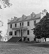 | October 9, 1974 (#74002005) | On County Road 1/4 39°21′28″N 77°54′29″W / 39.357778°N 77.908056°W / 39.357778; -77.908056 (Woodbury) | Leetown | |
| 83 | Woodbyrne | Upload image | August 2, 2024 (#100010589) | 219 Ann Lewis Road 39°11′01″N 77°52′16″W / 39.1836°N 77.8712°W / 39.1836; -77.8712 (Woodbyrne) | Charles Town | |
| 84 | Woodlawn | Upload image | March 24, 2000 (#00000254) | 30 Wiltshire Rd. 39°20′21″N 77°53′07″W / 39.339167°N 77.885278°W / 39.339167; -77.885278 (Woodlawn) | Kearneysville | |
| 85 | Robert Worthington House |  | July 2, 1973 (#73001913) | 2 mi (3.2 km) west of Charles Town off WV 51 39°17′46″N 77°53′23″W / 39.296111°N 77.889722°W / 39.296111; -77.889722 (Robert Worthington House) | Charles Town | |
| 86 | York Hill | 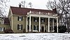 | July 26, 2006 (#06000654) | 1583 Ridge Rd. 39°22′36″N 77°50′47″W / 39.37667°N 77.84639°W / 39.37667; -77.84639 (York Hill) | Shenandoah Junction |
See also
Wikimedia Commons has media related to National Register of Historic Places in Jefferson County, West Virginia.
- List of National Historic Landmarks in West Virginia
- National Register of Historic Places listings in West Virginia
References
- ^ The latitude and longitude information provided in this table was derived originally from the National Register Information System, which has been found to be fairly accurate for about 99% of listings. Some locations in this table may have been corrected to current GPS standards.
- ^ National Park Service, United States Department of the Interior, "National Register of Historic Places: Weekly List Actions", retrieved August 16, 2024.
- ^ Numbers represent an alphabetical ordering by significant words. Various colorings, defined here, differentiate National Historic Landmarks and historic districts from other NRHP buildings, structures, sites or objects.
- ^ The eight-digit number below each date is the number assigned to each location in the National Register Information System database, which can be viewed by clicking the number.
- v
- t
- e

county
- Barbour
- Berkeley
- Boone
- Braxton
- Brooke
- Cabell
- Calhoun
- Clay
- Doddridge
- Fayette
- Gilmer
- Grant
- Greenbrier
- Hampshire
- Hancock
- Hardy
- Harrison
- Jackson
- Jefferson
- Kanawha
- Lewis
- Lincoln
- Logan
- Marion
- Marshall
- Mason
- McDowell
- Mercer
- Mineral
- Mingo
- Monongalia
- Monroe
- Morgan
- Nicholas
- Ohio
- Pendleton
- Pleasants
- Pocahontas
- Preston
- Putnam
- Raleigh
- Randolph
- Ritchie
- Roane
- Summers
- Taylor
- Tucker
- Tyler
- Upshur
- Wayne
- Webster
- Wetzel
- Wirt
- Wood
- Wyoming
 Category:National Register of Historic Places in West Virginia
 Portal:National Register of Historic Places


Municipalities and communities of Jefferson County, West Virginia, United States | ||
|---|---|---|
County seat: Charles Town | ||
| Cities |  | |
| Towns | ||
| CDPs | ||
| Other communities | ||
| ||


