National Register of Historic Places listings in Ohio County, West Virginia

This is a list of the National Register of Historic Places listings in Ohio County, West Virginia.
This is intended to be a complete list of the properties and districts on the National Register of Historic Places in Ohio County, West Virginia. The locations of National Register properties and districts for which the latitude and longitude coordinates are included below, may be seen in an online map.[1]
There are 52 properties and districts listed on the National Register in the county, 2 of which are National Historic Landmarks.
This National Park Service list is complete through NPS recent listings posted August 9, 2024.[2]
Map all coordinates using OpenStreetMap
Download coordinates as:
- KML
- GPX (all coordinates)
- GPX (primary coordinates)
- GPX (secondary coordinates)
Barbour - Berkeley - Boone - Braxton - Brooke - Cabell - Calhoun - Clay - Doddridge - Fayette - Gilmer - Grant - Greenbrier - Hampshire - Hancock - Hardy - Harrison - Jackson - Jefferson - Kanawha - Lewis - Lincoln - Logan - Marion - Marshall - Mason - McDowell - Mercer - Mineral - Mingo - Monongalia - Monroe - Morgan - Nicholas - Ohio - Pendleton - Pleasants - Pocahontas - Preston - Putnam - Raleigh - Randolph - Ritchie - Roane - Summers - Taylor - Tucker - Tyler - Upshur - Wayne - Webster - Wetzel - Wirt - Wood - Wyoming |
Current listings
| [3] | Name on the Register[4] | Image | Date listed[5] | Location | City or town | Description |
|---|---|---|---|---|---|---|
| 1 | Beagle Hotel |  | February 11, 1993 (#92000863) | 0.1 miles west of Valley Grove Rd. on the National Road 40°05′19″N 80°33′50″W / 40.088611°N 80.563889°W / 40.088611; -80.563889 (Beagle Hotel) | Valley Grove | Destroyed |
| 2 | Carter Farm |  | August 18, 1983 (#83003248) | Boggs Hill Rd. 40°05′10″N 80°39′26″W / 40.086111°N 80.657222°W / 40.086111; -80.657222 (Carter Farm) | Wheeling | |
| 3 | Cathedral Parish School |  | January 9, 1997 (#96001572) | Junction of 14th and Byron Sts. 40°03′59″N 80°43′10″W / 40.066389°N 80.719444°W / 40.066389; -80.719444 (Cathedral Parish School) | Wheeling | |
| 4 | Center Wheeling Market | 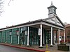 | February 20, 1975 (#75001896) | Market St. between 22nd and 23rd Sts. 40°03′32″N 80°43′27″W / 40.058889°N 80.724167°W / 40.058889; -80.724167 (Center Wheeling Market) | Wheeling | |
| 5 | Centre Market Square Historic District |  | January 12, 1984 (#84003651) | Roughly Market St. between 20th and 23rd Sts.; also the southern side of Main from Alley 19 to 20th St., and Chapline, Eoff and Charles Sts. bounded by Lane C, 22nd, and 24th Sts. 40°03′36″N 80°43′25″W / 40.06°N 80.723611°W / 40.06; -80.723611 (Centre Market Square Historic District) | Wheeling | Second set of boundaries represents a boundary increase of February 25, 1987 |
| 6 | Chapline Street Row Historic District |  | January 12, 1984 (#84003655) | 2301-2323 Chapline St. 40°03′28″N 80°43′27″W / 40.057778°N 80.724167°W / 40.057778; -80.724167 (Chapline Street Row Historic District) | Wheeling | |
| 7 | East Wheeling Historic District |  | November 22, 1999 (#99001402) | Roughly bounded by Chapline, Eoff, 18th, McColloch, 12th, and 11th Sts. 40°03′58″N 80°42′58″W / 40.066183°N 80.716188°W / 40.066183; -80.716188 (East Wheeling Historic District) | Wheeling | |
| 8 | Edemar |  | May 28, 1992 (#91001728) | 1330 National Road 40°04′09″N 80°40′52″W / 40.069167°N 80.681111°W / 40.069167; -80.681111 (Edemar) | Wheeling | |
| 9 | Elm Grove Stone Arch Bridge |  | August 21, 1981 (#81000606) | U.S. Route 40 40°02′37″N 80°39′32″W / 40.043611°N 80.658889°W / 40.043611; -80.658889 (Elm Grove Stone Arch Bridge) | Wheeling | |
| 10 | Elm Hill |  | December 4, 1991 (#91001732) | WV 88 southwest of the Wheeling Country Club 40°05′39″N 80°40′36″W / 40.094167°N 80.676667°W / 40.094167; -80.676667 (Elm Hill) | Wheeling | |
| 11 | Feay Inn |  | February 11, 1993 (#92000872) | 9 Burkham Ct. 40°02′55″N 80°38′37″W / 40.048611°N 80.643611°W / 40.048611; -80.643611 (Feay Inn) | Wheeling | |
| 12 | Fischer-Lasch Farmhouse |  | July 21, 1995 (#95000875) | 100 Waddles Run Rd. 40°05′15″N 80°40′43″W / 40.0875°N 80.678611°W / 40.0875; -80.678611 (Fischer-Lasch Farmhouse) | Wheeling | |
| 13 | Harry C. and Jessie F. Franzheim House |  | March 27, 1989 (#89000183) | 404 S. Front St. 40°04′01″N 80°43′45″W / 40.066944°N 80.729167°W / 40.066944; -80.729167 (Harry C. and Jessie F. Franzheim House) | Wheeling | |
| 14 | L. S. Good House |  | November 28, 1988 (#88002667) | 95 14th St. 40°03′59″N 80°43′02″W / 40.066389°N 80.717222°W / 40.066389; -80.717222 (L. S. Good House) | Wheeling | |
| 15 | Robert W. Hazlett House |  | May 2, 1991 (#91000552) | 921 N. Main St. 40°03′44″N 80°43′29″W / 40.062222°N 80.724722°W / 40.062222; -80.724722 (Robert W. Hazlett House) | Wheeling | |
| 16 | Highland Park Historic District | 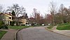 | April 7, 1993 (#93000222) | Highland Park, junction of Lincoln Dr. and National Road 40°03′06″N 80°39′53″W / 40.051667°N 80.664722°W / 40.051667; -80.664722 (Highland Park Historic District) | Wheeling | |
| 17 | La Belle Iron Works |  | November 24, 1997 (#97001415) | Junction of 31st and Wood Sts. 40°03′01″N 80°43′20″W / 40.050278°N 80.722222°W / 40.050278; -80.722222 (La Belle Iron Works) | Wheeling | |
| 18 | Lang-Hess House |  | March 22, 2006 (#06000174) | 1625 Wood St. 40°03′50″N 80°42′54″W / 40.063889°N 80.715000°W / 40.063889; -80.715000 (Lang-Hess House) | Wheeling | |
| 19 | Henry K. List House |  | October 4, 1978 (#78002807) | 827 Main St. 40°04′22″N 80°43′30″W / 40.072778°N 80.725000°W / 40.072778; -80.725000 (Henry K. List House) | Wheeling | |
| 20 | Johnson Camden McKinley House | 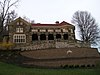 | August 18, 1983 (#83003251) | 147 Bethany Pike 40°05′14″N 80°41′35″W / 40.087222°N 80.693056°W / 40.087222; -80.693056 (Johnson Camden McKinley House) | Wheeling | |
| 21 | John McLure House |  | August 5, 1991 (#91001013) | 203 S. Front St. 40°04′08″N 80°43′46″W / 40.068889°N 80.729444°W / 40.068889; -80.729444 (John McLure House) | Wheeling | |
| 22 | Monroe Street East Historic District | 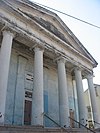 | February 12, 1980 (#80004036) | 12th and Byron Sts. 40°04′03″N 80°43′08″W / 40.067500°N 80.718889°W / 40.067500; -80.718889 (Monroe Street East Historic District) | Wheeling | |
| 23 | Mount de Chantal Visitation Academy |  | November 27, 1978 (#78002808) | Washington Ave. 40°04′10″N 80°41′38″W / 40.069444°N 80.693889°W / 40.069444; -80.693889 (Mount de Chantal Visitation Academy) | Wheeling | Demolished in November of 2011[6] |
| 24 | Mount Saint Joseph |  | January 17, 2008 (#07001418) | 137 Mt. Saint Joseph Rd. 40°06′49″N 80°39′30″W / 40.113611°N 80.658333°W / 40.113611; -80.658333 (Mount Saint Joseph) | Wheeling | |
| 25 | Mt. Woods Cemetery | 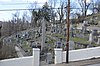 | September 4, 2013 (#13000685) | Mt. Wood Road., N. of 4th 40°04′51″N 80°43′20″W / 40.080833°N 80.722222°W / 40.080833; -80.722222 (Mt. Woods Cemetery) | Wheeling | |
| 26 | National Road Corridor Historic District | 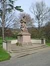 | February 11, 1993 (#92000874) | National Road from Bethany Pike to Park View Ln. 40°03′53″N 80°40′40″W / 40.064722°N 80.677778°W / 40.064722; -80.677778 (National Road Corridor Historic District) | Wheeling | |
| 27 | National Road Mile Markers Nos. 8, 9, 10, 11, 13, 14 |  | February 11, 1993 (#92000873) | Along the National Road from Mt. Echo to Triadelphia 40°04′27″N 80°35′38″W / 40.074167°N 80.593889°W / 40.074167; -80.593889 (National Road Mile Markers Nos. 8, 9, 10, 11, 13, 14) | Mt. Echo, Point Mills, Roney's Point, Triadelphia, Valley Camp, and Valley Grove | |
| 28 | North Wheeling Historic District |  | December 9, 1988 (#88002693) | Roughly bounded by Main Street Terrace, Market St., Interstate 70, and N. Main St.; also roughly bounded by 6th, Main, and Market Sts., and Main St. Terrace; also inclusive of area encompassed by Northern Pkwy, Ohio R., 6th St., and bluff to the east 40°04′28″N 80°43′29″W / 40.074444°N 80.724722°W / 40.074444; -80.724722 (North Wheeling Historic District) | Wheeling | Second and third sets of boundaries represent boundary increases approved January 17, 2008 and August 29, 2022 |
| 29 | H. C. Ogden House |  | July 12, 1990 (#90001067) | 12 Park Rd. 40°05′15″N 80°41′43″W / 40.0875°N 80.695278°W / 40.0875; -80.695278 (H. C. Ogden House) | Wheeling | |
| 30 | Oglebay Mansion Museum |  | August 29, 1979 (#79002595) | Oglebay Park 40°06′07″N 80°40′08″W / 40.101944°N 80.668889°W / 40.101944; -80.668889 (Oglebay Mansion Museum) | Wheeling | |
| 31 | Riverside Iron Works Office Building |  | March 17, 2015 (#15000096) | 1507-1509 Main St. 40°03′52″N 80°43′25″W / 40.064444°N 80.723611°W / 40.064444; -80.723611 (Riverside Iron Works Office Building) | Wheeling | |
| 32 | Charles W. Russell House |  | November 12, 1993 (#93001229) | 75 12th St. 40°04′03″N 80°43′15″W / 40.067500°N 80.720833°W / 40.067500; -80.720833 (Charles W. Russell House) | Wheeling | |
| 33 | Shaw Hall, West Liberty State College |  | December 27, 1996 (#96001528) | Bethany Pike, approximately 1.25 miles south of junction with Locust Grove Rd. 40°09′56″N 80°36′07″W / 40.165556°N 80.601944°W / 40.165556; -80.601944 (Shaw Hall, West Liberty State College) | West Liberty | |
| 34 | Shepherd Hall |  | December 18, 1970 (#70000661) | Monument Place and Kruger St. 40°02′33″N 80°39′33″W / 40.0425°N 80.659167°W / 40.0425; -80.659167 (Shepherd Hall) | Wheeling | |
| 35 | Shotwell Hall, West Liberty State College |  | December 27, 1996 (#96001529) | Bethany Pike, approximately 1.25 miles south of junction with Locust Grove Rd. 40°09′49″N 80°36′10″W / 40.163611°N 80.602778°W / 40.163611; -80.602778 (Shotwell Hall, West Liberty State College) | West Liberty | |
| 36 | South Wheeling Historic District |  | March 5, 2020 (#100003668) | Roughly bounded by WV 2 and 31st, 41st, and Chapline Sts. 40°02′52″N 80°43′30″W / 40.047722°N 80.725000°W / 40.047722; -80.725000 (South Wheeling Historic District) | Wheeling | |
| 37 | David Stewart Farm |  | May 29, 1979 (#79002594) | Dallas Pike, County Route 43 40°01′28″N 80°31′55″W / 40.024444°N 80.531944°W / 40.024444; -80.531944 (David Stewart Farm) | Triadelphia | |
| 38 | Stone Tavern at Roney's Point |  | February 11, 1993 (#92000864) | Junction of E. National and Roney's Point Rds. 40°04′25″N 80°35′57″W / 40.073611°N 80.599167°W / 40.073611; -80.599167 (Stone Tavern at Roney's Point) | Roney's Point | |
| 39 | William Miles Tiernan House |  | March 25, 1993 (#93000223) | 5 Kenwood Pl. 40°04′44″N 80°41′10″W / 40.078889°N 80.686111°W / 40.078889; -80.686111 (William Miles Tiernan House) | Wheeling | |
| 40 | Virginia Apartments | Upload image | November 3, 2022 (#100008380) | 902 Main St. 40°04′19″N 80°43′27″W / 40.0719°N 80.7243°W / 40.0719; -80.7243 (Virginia Apartments) | Wheeling | |
| 41 | Warwood Fire Station | 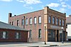 | May 2, 1996 (#96000440) | 1609 Warwood Ave. 40°07′04″N 80°41′56″W / 40.117778°N 80.698889°W / 40.117778; -80.698889 (Warwood Fire Station) | Wheeling | |
| 42 | West Liberty Presbyterian Church |  | July 3, 1980 (#80004407) | Main St. 40°10′07″N 80°35′36″W / 40.168611°N 80.593333°W / 40.168611; -80.593333 (West Liberty Presbyterian Church) | West Liberty | |
| 43 | West Virginia Independence Hall | 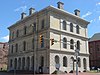 | January 26, 1970 (#70000660) | 1524 Market St. 40°03′51″N 80°43′46″W / 40.064167°N 80.729444°W / 40.064167; -80.729444 (West Virginia Independence Hall) | Wheeling | |
| 44 | Wheeling Baltimore and Ohio Railroad Passenger Station |  | March 26, 1979 (#79002596) | College Sq. 40°03′48″N 80°43′18″W / 40.063333°N 80.721667°W / 40.063333; -80.721667 (Wheeling Baltimore and Ohio Railroad Passenger Station) | Wheeling | |
| 45 | Wheeling Country Club |  | April 26, 1990 (#90000711) | 355 Oglebay Dr. 40°05′28″N 80°40′56″W / 40.091111°N 80.682222°W / 40.091111; -80.682222 (Wheeling Country Club) | Wheeling | |
| 46 | Wheeling Historic District |  | December 31, 1979 (#79002597) | Roughly bounded by railroad tracks, Eoff, Water, and 10th Sts. 40°04′02″N 80°43′14″W / 40.067222°N 80.720556°W / 40.067222; -80.720556 (Wheeling Historic District) | Wheeling | |
| 47 | Wheeling Island Historic District |  | April 2, 1992 (#92000320) | Roughly bounded by Stone, Front, North, Ontario, Erie, and Wabash Sts. 40°04′17″N 80°43′57″W / 40.071389°N 80.7325°W / 40.071389; -80.7325 (Wheeling Island Historic District) | Wheeling | Extends into Belmont County, Ohio |
| 48 | Wheeling Suspension Bridge |  | January 26, 1970 (#70000662) | Over the Ohio River from 10th St. in Wheeling to Virginia St. on Wheeling Island 40°04′13″N 80°43′38″W / 40.070278°N 80.727222°W / 40.070278; -80.727222 (Wheeling Suspension Bridge) | Wheeling | |
| 49 | Wheeling Warehouse Historic District |  | December 16, 2002 (#02001530) | Roughly along Main St., Water St., 21st St., 22nd St., South St., 18th St., Eoff St. and Chapline St.; also roughly bounded by Main, 20th, and east side of Market Sts., and Wheeling Cr. 40°03′39″N 80°43′22″W / 40.060833°N 80.722778°W / 40.060833; -80.722778 (Wheeling Warehouse Historic District) | Wheeling | Second set of addresses represent a boundary increase approved April 14, 2022. |
| 50 | Woodridge |  | July 6, 2005 (#05000658) | 1308 Steenrod Ave. 40°04′08″N 80°41′12″W / 40.068889°N 80.686667°W / 40.068889; -80.686667 (Woodridge) | Wheeling | |
| 51 | Robert C. Woods House |  | May 2, 1991 (#91000551) | 923 N. Main St. 40°04′16″N 80°43′29″W / 40.071111°N 80.724722°W / 40.071111; -80.724722 (Robert C. Woods House) | Wheeling | |
| 52 | Woodsdale-Edgewood Neighborhood Historic District |  | March 21, 1997 (#96000445) | Roughly bounded by Orchard Rd., Edgwood St., Carmel Rd., Bae-Mar, and Lenox to Wheeling Creek, and Pine St. to Park St. 40°04′35″N 80°40′58″W / 40.076389°N 80.682778°W / 40.076389; -80.682778 (Woodsdale-Edgewood Neighborhood Historic District) | Wheeling |
See also
Wikimedia Commons has media related to National Register of Historic Places in Ohio County, West Virginia.
- List of National Historic Landmarks in West Virginia
- National Register of Historic Places listings in West Virginia
References
- ^ The latitude and longitude information provided in this table was derived originally from the National Register Information System, which has been found to be fairly accurate for about 99% of listings. Some locations in this table may have been corrected to current GPS standards.
- ^ National Park Service, United States Department of the Interior, "National Register of Historic Places: Weekly List Actions", retrieved August 9, 2024.
- ^ Numbers represent an alphabetical ordering by significant words. Various colorings, defined here, differentiate National Historic Landmarks and historic districts from other NRHP buildings, structures, sites or objects.
- ^ "National Register Information System". National Register of Historic Places. National Park Service. April 24, 2008.
- ^ The eight-digit number below each date is the number assigned to each location in the National Register Information System database, which can be viewed by clicking the number.
- ^ http://www.pawv.org/endangerprogressreps.htm [dead link]
- v
- t
- e

county
- Barbour
- Berkeley
- Boone
- Braxton
- Brooke
- Cabell
- Calhoun
- Clay
- Doddridge
- Fayette
- Gilmer
- Grant
- Greenbrier
- Hampshire
- Hancock
- Hardy
- Harrison
- Jackson
- Jefferson
- Kanawha
- Lewis
- Lincoln
- Logan
- Marion
- Marshall
- Mason
- McDowell
- Mercer
- Mineral
- Mingo
- Monongalia
- Monroe
- Morgan
- Nicholas
- Ohio
- Pendleton
- Pleasants
- Pocahontas
- Preston
- Putnam
- Raleigh
- Randolph
- Ritchie
- Roane
- Summers
- Taylor
- Tucker
- Tyler
- Upshur
- Wayne
- Webster
- Wetzel
- Wirt
- Wood
- Wyoming
 Category:National Register of Historic Places in West Virginia
 Portal:National Register of Historic Places


Municipalities and communities of Ohio County, West Virginia, United States | ||
|---|---|---|
County seat: Wheeling | ||
| City |  | |
| Towns | ||
| Villages | ||
| Unincorporated communities | ||
| Footnotes | ‡This populated place also has portions in an adjacent county or counties | |
| ||


