National Register of Historic Places listings in Grady County, Oklahoma

This is a list of the National Register of Historic Places listings in Grady County, Oklahoma.
This is intended to be a complete list of the properties and districts on the National Register of Historic Places in Grady County, Oklahoma, United States. The locations of National Register properties and districts for which the latitude and longitude coordinates are included below, may be seen in a map.[1]
There are 13 properties and districts listed on the National Register in the county.
This National Park Service list is complete through NPS recent listings posted September 5, 2024.[2]
Map all coordinates using OpenStreetMap
Download coordinates as:
- KML
- GPX (all coordinates)
- GPX (primary coordinates)
- GPX (secondary coordinates)
Current listings
| [3] | Name on the Register[4] | Image | Date listed[5] | Location | City or town | Description |
|---|---|---|---|---|---|---|
| 1 | Chickasha Downtown Historic District |  | March 10, 2005 (#05000132) | Roughly bounded by 1st St., 3rd St., Kansas Ave., 7th St., and the alley north of Chickasa Ave. 35°03′04″N 97°56′14″W / 35.051111°N 97.937222°W / 35.051111; -97.937222 (Chickasha Downtown Historic District) | Chickasha | |
| 2 | Grady County Courthouse |  | March 10, 2005 (#05000131) | 326 W. Choctaw Ave. 35°03′09″N 97°56′07″W / 35.0525°N 97.935278°W / 35.0525; -97.935278 (Grady County Courthouse) | Chickasha | |
| 3 | Griffin House |  | June 9, 2014 (#14000297) | 1402 W. Kansas Ave. 35°03′01″N 97°57′03″W / 35.050191°N 97.950738°W / 35.050191; -97.950738 (Griffin House) | Chickasha | |
| 4 | Jewett Site | Upload image | February 14, 1979 (#79001995) | Address Restricted | Bradley | |
| 5 | Knippelmeir Farmstead |  | September 8, 2011 (#11000638) | 672 OK 152 35°20′07″N 97°59′41″W / 35.335278°N 97.994722°W / 35.335278; -97.994722 (Knippelmeir Farmstead) | Minco vicinity | |
| 6 | Minco Armory |  | May 20, 1994 (#94000484) | 407 W. Pontotoc St. 35°18′56″N 97°56′46″W / 35.315556°N 97.946111°W / 35.315556; -97.946111 (Minco Armory) | Minco | |
| 7 | New Hope Baptist Church |  | June 5, 2003 (#03000515) | 1202 S. Shepherd St. 35°02′20″N 97°55′51″W / 35.038889°N 97.930833°W / 35.038889; -97.930833 (New Hope Baptist Church) | Chickasha | |
| 8 | Oklahoma College for Women Historic District | 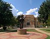 | September 9, 2001 (#01000950) | roughly bounded by Grand Ave., 19th St., Alabama Ave., and the alley west of 15th St. 35°01′51″N 97°57′17″W / 35.030833°N 97.954722°W / 35.030833; -97.954722 (Oklahoma College for Women Historic District) | Chickasha | |
| 9 | Pocasset Gymnasium |  | December 13, 1996 (#96001489) | 0.5 miles south of junction of Dutton Rd. and U.S. Highway 81 35°11′31″N 97°57′17″W / 35.191944°N 97.954722°W / 35.191944; -97.954722 (Pocasset Gymnasium) | Pocasset | |
| 10 | Rock Island Depot | 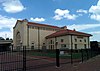 | March 29, 1985 (#85000699) | Chickasha Ave. 35°03′07″N 97°55′55″W / 35.051944°N 97.931944°W / 35.051944; -97.931944 (Rock Island Depot) | Chickasha | |
| 11 | Silver City Cemetery |  | December 4, 2008 (#08001149) | 6/10 mile from the section line on the southern side of section 22, T10N, R6W I.M. 35°19′42″N 97°44′54″W / 35.328333°N 97.748333°W / 35.328333; -97.748333 (Silver City Cemetery) | Tuttle | |
| 12 | US Post Office and Federal Courthouse |  | December 29, 1994 (#94001509) | Southwestern corner of the junction of 4th and Choctaw Sts. 35°03′07″N 97°56′12″W / 35.051944°N 97.936667°W / 35.051944; -97.936667 (US Post Office and Federal Courthouse) | Chickasha | |
| 13 | Verden Separate School |  | December 16, 2005 (#05001416) | 315 E. Ada Sipuel Ave. 35°02′39″N 97°55′43″W / 35.044167°N 97.928611°W / 35.044167; -97.928611 (Verden Separate School) | Chickasha |
See also
Wikimedia Commons has media related to National Register of Historic Places in Grady County, Oklahoma.
- List of National Historic Landmarks in Oklahoma
- National Register of Historic Places listings in Oklahoma
References
- ^ The latitude and longitude information provided in this table was derived originally from the National Register Information System, which has been found to be fairly accurate for about 99% of listings. Some locations in this table may have been corrected to current GPS standards.
- ^ National Park Service, United States Department of the Interior, "National Register of Historic Places: Weekly List Actions", retrieved September 5, 2024.
- ^ Numbers represent an alphabetical ordering by significant words. Various colorings, defined here, differentiate National Historic Landmarks and historic districts from other NRHP buildings, structures, sites or objects.
- ^ "National Register Information System". National Register of Historic Places. National Park Service. March 13, 2009.
- ^ The eight-digit number below each date is the number assigned to each location in the National Register Information System database, which can be viewed by clicking the number.
- v
- t
- e
- List of U.S. National Historic Landmarks by state:
- Alabama
- Alaska
- Arizona
- Arkansas
- California
- Colorado
- Connecticut
- Delaware
- Florida
- Georgia
- Hawaii
- Idaho
- Illinois
- Indiana
- Iowa
- Kansas
- Kentucky
- Louisiana
- Maine
- Maryland
- Massachusetts
- Michigan
- Minnesota
- Mississippi
- Missouri
- Montana
- Nebraska
- Nevada
- New Hampshire
- New Jersey
- New Mexico
- New York
- North Carolina
- North Dakota
- Ohio
- Oklahoma
- Oregon
- Pennsylvania
- Rhode Island
- South Carolina
- South Dakota
- Tennessee
- Texas
- Utah
- Vermont
- Virginia
- Washington
- West Virginia
- Wisconsin
- Wyoming
 National Register of Historic Places portal
 Category


Municipalities and communities of Grady County, Oklahoma, United States | ||
|---|---|---|
County seat: Chickasha | ||
| Cities |  | |
| Towns | ||
| CDP | ||
| Other communities | ||
| Ghost towns | ||
| Indian reservation | ||
| Footnotes | ‡This populated place also has portions in an adjacent county or counties | |
| ||


