National Register of Historic Places listings in Payne County, Oklahoma

This is a list of the National Register of Historic Places listings in Payne County, Oklahoma.
This is intended to be a complete list of the properties and districts on the National Register of Historic Places in Payne County, Oklahoma, United States. The locations of National Register properties and districts for which the latitude and longitude coordinates are included below, may be seen in a map.[1]
There are 32 properties and districts listed on the National Register in the county.
This National Park Service list is complete through NPS recent listings posted September 5, 2024.[2]
Map all coordinates using OpenStreetMap
Download coordinates as:
- KML
- GPX (all coordinates)
- GPX (primary coordinates)
- GPX (secondary coordinates)
Current listings
| [3] | Name on the Register[4] | Image | Date listed[5] | Location | City or town | Description |
|---|---|---|---|---|---|---|
| 1 | The Bassett House |  | December 3, 2009 (#09000979) | 1100 E. 9th Pl. 35°58′20″N 96°45′23″W / 35.9722°N 96.7565°W / 35.9722; -96.7565 (The Bassett House) | Cushing | |
| 2 | James E. Berry House |  | November 21, 1980 (#80003294) | 502 S. Duck St. 36°06′59″N 97°03′44″W / 36.1164°N 97.0622°W / 36.1164; -97.0622 (James E. Berry House) | Stillwater | |
| 3 | Luke D. Berry House |  | December 11, 2007 (#07001262) | 621 E. Broadway St. 35°58′47″N 96°45′55″W / 35.9797°N 96.7653°W / 35.9797; -96.7653 (Luke D. Berry House) | Cushing | |
| 4 | Campus Fire Station |  | December 7, 2004 (#04001336) | 600 W. University Ave. 36°07′12″N 97°03′54″W / 36.12°N 97.065°W / 36.12; -97.065 (Campus Fire Station) | Stillwater | |
| 5 | Citizens Bank Building | 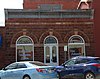 | February 24, 1981 (#81000467) | 107 E. 9th St. 36°06′46″N 97°03′29″W / 36.1128°N 97.0581°W / 36.1128; -97.0581 (Citizens Bank Building) | Stillwater | |
| 6 | Cottonwood Community Center | 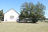 | March 13, 1980 (#80004291) | Northwest of Stillwater 36°08′43″N 97°09′29″W / 36.1453°N 97.1581°W / 36.1453; -97.1581 (Cottonwood Community Center) | Stillwater | |
| 7 | Hamilton Cross House | 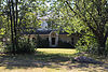 | June 9, 2014 (#14000298) | 1509 W. 9th 36°06′42″N 97°04′35″W / 36.1118°N 97.0765°W / 36.1118; -97.0765 (Hamilton Cross House) | Stillwater | |
| 8 | Cushing American Legion Building |  | June 5, 2003 (#03000514) | 212 S. Noble 35°58′41″N 96°46′10″W / 35.9781°N 96.7694°W / 35.9781; -96.7694 (Cushing American Legion Building) | Cushing | |
| 9 | Cushing Armory |  | May 20, 1994 (#94000480) | 218 S. Little Ave. 35°58′42″N 96°46′00″W / 35.9783°N 96.7667°W / 35.9783; -96.7667 (Cushing Armory) | Cushing | |
| 10 | William Frick House |  | September 8, 1980 (#80004292) | 1016 S. West St. 36°06′36″N 97°03′47″W / 36.11°N 97.0631°W / 36.11; -97.0631 (William Frick House) | Stillwater | |
| 11 | Gillespie Drilling Company Building |  | December 12, 2012 (#12001039) | 317 W. Broadway 35°58′47″N 96°46′33″W / 35.9796°N 96.7758°W / 35.9796; -96.7758 (Gillespie Drilling Company Building) | Cushing | |
| 12 | Hoke Building |  | September 12, 1983 (#83002118) | 121 W. 7th Ave. 36°06′51″N 97°03′34″W / 36.1142°N 97.0594°W / 36.1142; -97.0594 (Hoke Building) | Stillwater | |
| 13 | Hopkins Sandstone House and Farmstead | Upload image | May 7, 1979 (#79002017) | Northeast of Ripley 36°02′30″N 96°51′42″W / 36.0417°N 96.8617°W / 36.0417; -96.8617 (Hopkins Sandstone House and Farmstead) | Ripley | |
| 14 | Irvings Castle | Upload image | February 17, 1978 (#78002257) | 2.5 miles (4 km) south of Ingalls 36°03′46″N 96°53′33″W / 36.0628°N 96.8925°W / 36.0628; -96.8925 (Irvings Castle) | Ingalls | |
| 15 | Long Branch Creek Bridge | 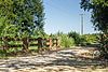 | September 10, 2014 (#14000596) | 1/8 mi. N. of jct. of N3300 & E0540 36°13′54″N 97°06′21″W / 36.2318°N 97.1058°W / 36.2318; -97.1058 (Long Branch Creek Bridge) | Stillwater vicinity | |
| 16 | Lytton Building-Masonic Hall |  | June 7, 2021 (#100006630) | 907-909 South Main St. 36°06′43″N 97°03′31″W / 36.1120°N 97.0585°W / 36.1120; -97.0585 (Lytton Building-Masonic Hall) | Stillwater | |
| 16 | Magruder Plots |  | August 29, 1979 (#79002018) | Oklahoma State University 36°07′01″N 97°05′15″W / 36.116944°N 97.0875°W / 36.116944; -97.0875 (Magruder Plots) | Stillwater | |
| 17 | Murphy House | 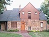 | September 18, 1986 (#86002173) | 419 S. Monroe 36°07′00″N 97°04′16″W / 36.116667°N 97.071111°W / 36.116667; -97.071111 (Murphy House) | Stillwater | |
| 18 | Oklahoma A & M College Agronomy Barn and Seed House |  | May 27, 2004 (#04000519) | 2902 W. 6th St. Building #610 36°07′02″N 97°05′37″W / 36.117222°N 97.093611°W / 36.117222; -97.093611 (Oklahoma A & M College Agronomy Barn and Seed House) | Stillwater | |
| 19 | Oklahoma A&M College Dairy Barn | Upload image | December 10, 2014 (#14001030) | 2624 W. McElroy Rd. 36°07′50″N 97°05′17″W / 36.1305°N 97.088°W / 36.1305; -97.088 (Oklahoma A&M College Dairy Barn) | Stillwater | |
| 20 | Old Central, Oklahoma State University |  | July 27, 1971 (#71000672) | Oklahoma State University campus 36°07′14″N 97°03′59″W / 36.120556°N 97.066389°W / 36.120556; -97.066389 (Old Central, Oklahoma State University) | Stillwater | |
| 21 | Payne County Courthouse |  | August 23, 1984 (#84003410) | 606 S. Husband St. 36°06′55″N 97°03′37″W / 36.115278°N 97.060278°W / 36.115278; -97.060278 (Payne County Courthouse) | Stillwater | |
| 22 | Perkins Downtown Historic District |  | December 28, 2000 (#00001578) | 100 block of Main St. bounded by Stumbo and Thomas Sts. 35°58′24″N 97°02′01″W / 35.973333°N 97.033611°W / 35.973333; -97.033611 (Perkins Downtown Historic District) | Perkins | |
| 23 | Pleasant Valley School |  | January 25, 1991 (#90002182) | 1901 S. Sangre Rd. 36°06′02″N 97°06′16″W / 36.100556°N 97.104444°W / 36.100556; -97.104444 (Pleasant Valley School) | Stillwater | |
| 24 | Pruett House | Upload image | September 7, 2016 (#16000622) | 155 Redwood Dr. 36°07′12″N 97°04′36″W / 36.120113°N 97.076662°W / 36.120113; -97.076662 (Pruett House) | Stillwater | |
| 25 | Josephine Reifsnyder Lustron House |  | February 23, 2009 (#09000078) | 2119 Sherwood 36°07′19″N 97°05′04″W / 36.121872°N 97.084499°W / 36.121872; -97.084499 (Josephine Reifsnyder Lustron House) | Stillwater | |
| 26 | Selph Building |  | September 12, 1983 (#83002119) | 119 W. 7th Ave. 36°06′51″N 97°03′33″W / 36.114167°N 97.059167°W / 36.114167; -97.059167 (Selph Building) | Stillwater | |
| 27 | Stillwater Santa Fe Depot |  | March 3, 1980 (#80004293) | 400 E. 10th St. 36°06′46″N 97°03′16″W / 36.112778°N 97.054444°W / 36.112778; -97.054444 (Stillwater Santa Fe Depot) | Stillwater | |
| 28 | Jim Thorpe House |  | March 24, 1971 (#71000673) | 704 E. Boston St. 36°06′49″N 96°48′38″W / 36.113611°N 96.810556°W / 36.113611; -96.810556 (Jim Thorpe House) | Yale | As of mid-2024, a museum owned by the Thorpe family.[6] |
| 29 | Christian K. Usher Luston House |  | February 23, 2009 (#09000079) | 1135 E. Moses 35°58′52″N 96°45′21″W / 35.981111°N 96.755833°W / 35.981111; -96.755833 (Christian K. Usher Luston House) | Cushing | |
| 30 | Walker Building |  | September 12, 1983 (#83002120) | 117 W. 7th Ave. 36°06′51″N 97°03′33″W / 36.114167°N 97.059167°W / 36.114167; -97.059167 (Walker Building) | Stillwater | |
| 31 | White Cloud Lodge |  | September 3, 2010 (#10000619) | 820 E. 146th St. 35°56′57″N 97°02′53″W / 35.949167°N 97.048056°W / 35.949167; -97.048056 (White Cloud Lodge) | Perkins |
See also
Wikimedia Commons has media related to National Register of Historic Places in Payne County, Oklahoma.
- List of National Historic Landmarks in Oklahoma
- National Register of Historic Places listings in Oklahoma
References
- ^ The latitude and longitude information provided in this table was derived originally from the National Register Information System, which has been found to be fairly accurate for about 99% of listings. Some locations in this table may have been corrected to current GPS standards.
- ^ National Park Service, United States Department of the Interior, "National Register of Historic Places: Weekly List Actions", retrieved September 5, 2024.
- ^ Numbers represent an alphabetical ordering by significant words. Various colorings, defined here, differentiate National Historic Landmarks and historic districts from other NRHP buildings, structures, sites or objects.
- ^ "National Register Information System". National Register of Historic Places. National Park Service. March 13, 2009.
- ^ The eight-digit number below each date is the number assigned to each location in the National Register Information System database, which can be viewed by clicking the number.
- ^ "SOLD: Thorpe family buys Jim Thorpe's Yale home from Oklahoma Historical Society". KJRH Tulsa, July 31, 2024. Retrieved July 31, 2024.
- v
- t
- e
- Bassett House
- Berry House
- Cushing American Legion Building
- Cushing Armory
- Gillespie Drilling Company Building
- Luston House

- Irvings Castle
- Perkins Downtown Historic District
- White Cloud Lodge
- Hopkins Sandstone House and Farmstead
- Berry House
- Campus Fire Station
- Citizens Bank Building
- Cottonwood Community Center
- Cross House
- Frick House
- Hoke Building
- Josephine Reifsnyder Lustron House
- Long Branch Creek Bridge
- Magruder Plots
- Murphy House
- Oklahoma A & M College Agronomy Barn and Seed House
- Oklahoma A&M College Dairy Barn
- Old Central
- Payne County Courthouse
- Pleasant Valley School
- Pruett House
- Selph Building
- Stillwater Santa Fe Depot
- Walker Building
See also: National Register of Historic Places listings in Payne County, Oklahoma and List of National Historic Landmarks in Oklahoma
| |
|---|---|
| Topics | |
| Lists by state |
|
| Lists by insular areas | |
| Lists by associated state | |
| Other areas | |
| Related | |
| |


Municipalities and communities of Payne County, Oklahoma, United States | ||
|---|---|---|
County seat: Stillwater | ||
| Cities | 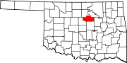 | |
| Towns | ||
| CDPs | ||
| Other communities | ||
| Ghost town | ||
| Footnotes | ‡This populated place also has portions in an adjacent county or counties | |
| ||


