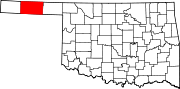
National Register of Historic Places listings in Texas County, Oklahoma

This is a list of the National Register of Historic Places listings in Texas County, Oklahoma.
This is intended to be a complete list of the properties on the National Register of Historic Places in Texas County, Oklahoma, United States. The locations of National Register properties for which the latitude and longitude coordinates are included below, may be seen in a map.[1]
There are 24 properties listed on the National Register in the county, including 1 National Historic Landmark.
This National Park Service list is complete through NPS recent listings posted September 5, 2024.[2]
Map all coordinates using OpenStreetMap
Download coordinates as:
- KML
- GPX (all coordinates)
- GPX (primary coordinates)
- GPX (secondary coordinates)
Current listings
| [3] | Name on the Register[4] | Image | Date listed[5] | Location | City or town | Description |
|---|---|---|---|---|---|---|
| 1 | Adams Woodframe Grain Elevator | Upload image | May 13, 1983 (#83002129) | North of State Highway 3 36°45′26″N 101°04′22″W / 36.757222°N 101.072778°W / 36.757222; -101.072778 (Adams Woodframe Grain Elevator) | Adams | Condemned and burned down[6] |
| 2 | Elmer Baker Barn | 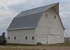 | December 12, 2012 (#12001040) | Mile 47 Rd. 36°51′43″N 101°10′48″W / 36.86188°N 101.18001°W / 36.86188; -101.18001 (Elmer Baker Barn) | Hooker | |
| 3 | Baker Woodframe Elevator | Upload image | May 13, 1983 (#83002130) | SR 2847 36°52′14″N 101°01′03″W / 36.870556°N 101.0175°W / 36.870556; -101.0175 (Baker Woodframe Elevator) | Baker | |
| 4 | Baker Woodframe Grain Elevator | Upload image | May 13, 1983 (#83002131) | Off U.S. Route 64 36°52′12″N 101°01′00″W / 36.87°N 101.016667°W / 36.87; -101.016667 (Baker Woodframe Grain Elevator) | Baker | |
| 5 | CCC Ranch Headquarters | Upload image | December 1, 1983 (#83004218) | West of Texhoma 36°44′52″N 101°53′53″W / 36.747778°N 101.898056°W / 36.747778; -101.898056 (CCC Ranch Headquarters) | Texhoma | |
| 6 | Danholt |  | June 14, 2013 (#13000394) | 1208 N. May 36°41′24″N 101°28′36″W / 36.690089°N 101.476744°W / 36.690089; -101.476744 (Danholt) | Guymon | |
| 7 | Easterwood Archeological Site | Upload image | November 16, 1978 (#78002264) | Address restricted | Guymon | |
| 8 | Eva Woodframe Grain Elevator | Upload image | May 13, 1983 (#83002132) | State Highway 95 36°47′53″N 101°54′17″W / 36.798056°N 101.904722°W / 36.798056; -101.904722 (Eva Woodframe Grain Elevator) | Eva | |
| 9 | Franklin Hall | 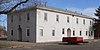 | September 6, 2007 (#07000909) | 201 N. College Ave. 36°35′39″N 101°38′09″W / 36.594167°N 101.63583°W / 36.594167; -101.63583 (Franklin Hall) | Goodwell | |
| 10 | Hooker Woodframe Grain Elevator |  | May 13, 1983 (#83002133) | Off Texas Ave. 36°52′03″N 101°12′42″W / 36.8676°N 101.21178°W / 36.8676; -101.21178 (Hooker Woodframe Grain Elevator) | Hooker | |
| 11 | Hotel Dale | 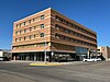 | June 13, 2016 (#16000376) | 118 NW. 6th St. 36°41′02″N 101°28′56″W / 36.683889°N 101.482117°W / 36.683889; -101.482117 (Hotel Dale) | Guymon | By April 2024, the Dale Lofts |
| 12 | Hough Woodframe Elevator | Upload image | May 13, 1983 (#83002134) | State Highway 95 36°52′14″N 101°34′35″W / 36.870556°N 101.576389°W / 36.870556; -101.576389 (Hough Woodframe Elevator) | Hough | |
| 13 | Johnson-Cline Archeological Site | Upload image | November 16, 1978 (#78002267) | Address restricted | Texhoma | |
| 14 | Mouser Grain Elevator | Upload image | October 7, 1983 (#83004220) | Off State Highway 136 36°52′14″N 101°24′49″W / 36.870556°N 101.413611°W / 36.870556; -101.413611 (Mouser Grain Elevator) | Mouser | |
| 15 | Mouser Woodframe Grain Elevator/Collingwood Elevator | Upload image | May 13, 1983 (#83002135) | Off State Highway 136 36°52′14″N 101°24′58″W / 36.870556°N 101.416111°W / 36.870556; -101.416111 (Mouser Woodframe Grain Elevator/Collingwood Elevator) | Mouser | |
| 16 | Nash II-Clawson Archeological Site | Upload image | October 2, 1978 (#78002265) | Address restricted | Guymon | |
| 17 | Old Hardesty | Upload image | June 20, 1974 (#74001669) | Address restricted | Hardesty | |
| 18 | Optima Grain Elevator | Upload image | May 13, 1983 (#83002136) | U.S. Route 54 36°45′41″N 101°21′17″W / 36.761389°N 101.354722°W / 36.761389; -101.354722 (Optima Grain Elevator) | Optima | |
| 19 | Penick House |  | September 28, 1984 (#84003436) | 218 N. East St. 36°30′23″N 101°46′51″W / 36.506461°N 101.780869°W / 36.506461; -101.780869 (Penick House) | Texhoma | |
| 20 | Shores Archeological Site | Upload image | November 27, 1978 (#78002263) | Address restricted | Eva | |
| 21 | Stamper site | Upload image | October 15, 1966 (#66000635) | Address restricted | Optima | |
| 22 | Texas County Courthouse | 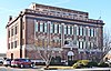 | August 24, 1984 (#84003439) | 319 N. Main St. 36°40′53″N 101°28′52″W / 36.6815°N 101.4811°W / 36.6815; -101.4811 (Texas County Courthouse) | Guymon | |
| 23 | Tracey Woodframe Grain Elevator | Upload image | May 13, 1983 (#83002137) | North of U.S. Route 64 36°49′15″N 101°45′39″W / 36.820833°N 101.760833°W / 36.820833; -101.760833 (Tracey Woodframe Grain Elevator) | Muncey | |
| 24 | Two Sisters Archeological Site | Upload image | October 2, 1978 (#78002266) | Address restricted | Guymon |
See also
Wikimedia Commons has media related to National Register of Historic Places in Texas County, Oklahoma.
- List of National Historic Landmarks in Oklahoma
- National Register of Historic Places listings in Oklahoma
References
- ^ The latitude and longitude information provided in this table was derived originally from the National Register Information System, which has been found to be fairly accurate for about 99% of listings. Some locations in this table may have been corrected to current GPS standards.
- ^ National Park Service, United States Department of the Interior, "National Register of Historic Places: Weekly List Actions", retrieved September 5, 2024.
- ^ Numbers represent an alphabetical ordering by significant words. Various colorings, defined here, differentiate National Historic Landmarks and historic districts from other NRHP buildings, structures, sites or objects.
- ^ "National Register Information System". National Register of Historic Places. National Park Service. March 13, 2009.
- ^ The eight-digit number below each date is the number assigned to each location in the National Register Information System database, which can be viewed by clicking the number.
- ^ "Iconic leaning elevator in Oklahoma panhandle is demolished". K. Querry, KFOR-TV, August 22, 2018. Retrieved January 5, 2021.
- v
- t
- e
- List of U.S. National Historic Landmarks by state:
- Alabama
- Alaska
- Arizona
- Arkansas
- California
- Colorado
- Connecticut
- Delaware
- Florida
- Georgia
- Hawaii
- Idaho
- Illinois
- Indiana
- Iowa
- Kansas
- Kentucky
- Louisiana
- Maine
- Maryland
- Massachusetts
- Michigan
- Minnesota
- Mississippi
- Missouri
- Montana
- Nebraska
- Nevada
- New Hampshire
- New Jersey
- New Mexico
- New York
- North Carolina
- North Dakota
- Ohio
- Oklahoma
- Oregon
- Pennsylvania
- Rhode Island
- South Carolina
- South Dakota
- Tennessee
- Texas
- Utah
- Vermont
- Virginia
- Washington
- West Virginia
- Wisconsin
- Wyoming
 National Register of Historic Places portal
 Category