Sayres Benchmark


Sayres Benchmark
Location in Colorado
Show map of Colorado
Sayres Benchmark
Sayres Benchmark (the United States)
Show map of the United StatesSawatch Range
Collegiate Peaks[2]
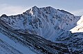
Sayres Benchmark is a 13,746-foot-elevation (4,190-meter) mountain summit in Chaffee County, Colorado, United States.
Description
Sayres Benchmark is located three miles (4.8 km) east of the Continental Divide in the Collegiate Peaks which are a subset of the Sawatch Range. The mountain is set on the boundary of the Collegiate Peaks Wilderness on land managed by San Isabel National Forest.[1] The highest peak in Colorado and the Rocky Mountains, Mount Elbert, is 7.46 miles (12.01 km) north-northeast of Sayres Benchmark, and the fifth-highest, La Plata Peak, is less than two miles to the northeast.[2] Sayres ranks as the 130th-highest summit in Colorado.[1] Precipitation runoff from the mountain's south slope drains into Clear Creek, whereas the north slope drains to Lake Creek, and both are tributaries of the Arkansas River. Topographic relief is significant as the summit rises 2,950 feet (899 m) above North Fork Clear Creek in 1.5 miles (2.4 km). An ascent of Sayres involves 10 miles of hiking with 3,500-feet of elevation gain.[3] In winter the peak offers excellent ski mountaineering on its rugged north face.[4]
Climate
According to the Köppen climate classification system, Sayres Benchmark is located in an alpine subarctic climate zone with cold, snowy winters, and cool to warm summers.[5] Due to its elevation, it receives precipitation all year, as snow in winter and as thunderstorms in summer, with a dry period in late spring. Climbers can expect afternoon rain, hail, and lightning from the seasonal monsoon in late July and August.
Gallery
-
 North face
 -
 Southeast aspect
 -
 Sayres Benchmark in winter


See also
 Mountains portal
- Mountains of Chaffee County, Colorado
- Thirteener

References
- ^ a b c d e f g "Sayres Benchmark - 13,746' CO". listsofjohn.com. Retrieved July 11, 2023.
- ^ a b c "Sayres Benchmark, Colorado". Peakbagger.com. Retrieved July 11, 2023.
- ^ Mike Garratt, Bob Martin (1984), Colorado's High Thirteeners, Johnson Books, ISBN 9780917895395, p. 39.
- ^ Ben Conners, Brian Miller, Climbing and Skiing Colorado's Mountains: Over 50 Select Ski Descents, Rowman & Littlefield (2020), ISBN 9781493046737, p. 175.
- ^ Peel, M. C.; Finlayson, B. L.; McMahon, T. A. (2007). "Updated world map of the Köppen−Geiger climate classification". Hydrol. Earth Syst. Sci. 11. ISSN 1027-5606.
External links
- National Geodetic Survey data sheet
Places adjacent to Sayres Benchmark | ||||||||||||||||
|---|---|---|---|---|---|---|---|---|---|---|---|---|---|---|---|---|
| ||||||||||||||||


- v
- t
- e

- Mount Garfield
- Aspen Mountain
- Capitol Peak
- Castle Peak
- Cathedral Peak
- Chair Mountain
- Crested Butte
- Gothic Mountain
- Italian Mountain
- Maroon Bells
- Mount Emmons
- Mount Owen
- Mount Sopris
- Pyramid Peak
- Snowmass Mountain
- Snowmass Peak
- Treasure Mountain
- Black Mountain (Moffat County)
- Columbus Mountain
- Elk Mountain (Routt County)
- Hahns Peak
- Flat Top Mountain
- Sleepy Cat Peak
- Eagles Nest
- Jacque Peak
- Meridian Peak
- Mount Powell
- The Spider
- Crater Peak
- North Mamm Peak
- Clark Peak
- Arkansas Hills
- Clinton Peak
- Dyer Mountain
- Gemini Peak
- Horseshoe Mountain
- Mount Arkansas
- Mount Bross
- Mount Buckskin
- Mount Democrat
- Mount Lincoln
- Mount Sheridan
- Mount Sherman
- Pacific Peak
- West Buffalo Peak
- Elk Mountain (Grand County)
- Parkview Mountain
- Radial Mountain
- Whiteley Peak
| Sangre de Cristo Range |
|
|---|---|
| Wet Mountains |
|
| Others |
|
| Collegiate Peaks |
|
|---|---|
| Others |
|
- Crystal Peak
- Fletcher Mountain
- Peak 10
- Peak One
- Quandary Peak
- Tenmile Peak
- Bear Mountain
- Blair Mountain
- Chalk Mountains
- Cochetopa Hills
- Dawson Butte
- Diamond Peak
- Flirtation Peak
- Granite Peak
- Grand Hogback
- Grannys Nipple
- Horsefly Peak
- Lead Mountain (Grand County)
- Mount Neva
- Powell Peak
- San Luis Hills
- Storm King Mountain
- Terrible Mountain
- Two Buttes
- Ute Mountain


